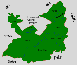
Kahuta Tehsil
Kahuta Tehsil (Urdu: تحصیل کہوٹہ) is one of the eight tehsils (subdivisions) of Rawalpindi District in the Punjab province of Pakistan. The neighbouring tehsil of Kallar Sayedan used to be part of Kahuta, but was later created as separate tehsil. The name Kahuta was derived from "Koh" a local medicinal tree (Look the leaves as Oliven) and "Boota". Perhaps "Koh Boota" was shortened to Kohuta/Kahuta over the passage of time.
Kahuta Tehsil | |
|---|---|
Tehsil | |
 | |
| Country | Pakistan |
| Region | Punjab |
| District | Rawalpindi District |
| Capital | Kahuta |
| Towns | 1 |
| Union councils | 13 |
| Population (2017) | |
| • Total | 220,576 |
| Time zone | UTC+5 (PST) |
History
In 997 CE, Sultan Mahmud Ghaznavi, took over the Ghaznavid dynasty empire established by his father, Sultan Sebuktegin, In 1005 he conquered the Shahis in Kabul in 1005, and followed it by the conquests of Punjab region. The Delhi Sultanate and later Mughal Empire ruled the region. The Punjab region became predominantly Muslim due to missionary Sufi saints whose dargahs dot the landscape of Punjab region.
After the decline of the Mughal Empire, the Sikh Empire invaded and occupied Rawalpindi District. The Muslims faced restrictions during the Sikh rule. During the period of British rule, Kahuta Tehsil increased in population and importance.
In the 18th century, Kahuta along with much of the South Asia became part of British India, the undivided tehsil (which includes what is now Kallar Syedan Tehsil) is described in the "Imperial Gazetteer of India" as follows:
Kahuta-Eastern tehsil of Rawalpindi District, Punjab, lying in the Lower Himalayas, between 33° 18′ and 33° 48′ N. and 73° 15′ and 73° 39′ E., with an area of 206 square miles. Its eastern border rests upon the Jhelum River. The whole of the tahsil except the south-west corner lies in the hills, which in the north reach an elevation of over 6,000 feet. The population in 1911 was 94,719, compared with 91,371 in 1891. It contains 231 villages, of which Kahuta is the headquarters. The land revenue and cesses amounted in 1913-4 to 1.2 lakhs.[1]
The predominantly Muslim population supported Muslim League and Pakistan Movement. After the independence of Pakistan in 1947, the minority Hindus and Sikhs migrated to India while the Muslims refugees from India settled down in the Rawalpindi District.
Administration
The tehsil is administratively divided into 13 Union Councils, two of which form the city of Kahuta; these are:[2]
| UC34 | Names of UC's |
|---|---|
| Uc-30 | Narar |
| Uc-31 | Punjar |
| Uc-32 | Khadiot |
| Uc-33 | Doberan Khurd |
| Uc-34 | Mowara |
| Uc-35 | Beor |
| Uc-36 | Matore |
| Uc-37 | Nara |
| Uc-38 | Dakhali |
| Uc-39 | Hothla |
| Uc-47 | Kahuta I |
| Uc-48 | Kahuta II |
| Uc-116 | Khalol |
| Uc-117 | Lehri |
Demography
The population of the Kahuta Tehsil is approximately 220,576 according to the latest Complete census of Pakistan which was held in 2017,
Many Tribes are living in Kahuta like Janjuas, Jandran’s Dhund Abbasis, Jasgam Abbasis, Sudhans, Syeds, Sheikhs, Sattis, Awans, Gakkhars, Gujjars, Khattars, Qazis, Junhals, Mughals, Chauhans Siddiquis, & many others.
See also
- Demography of Rawalpindi District
