Kagarko
Kagarko (also Wogon) is a Local Government Area in southern Kaduna State, Nigeria. Its headquarters are in the town of Kagarko. It has an area of 1,864 km² and a population of 240,943 at the 2006 census. The postal code is 802.[1]
Kagarko Wogon | |
|---|---|
LGA and Town | |
| Nickname(s): Garin Bubu | |
 Kagarko Location in Nigeria | |
| Coordinates: 9°27′0″N 7°41′0″E | |
| Country | |
| State | Kaduna State |
| Government | |
| • Local Government Chairman | Nasara Rabo |
| Time zone | UTC+1 (WAT) |
| Website | www.kagarkolocalgovernment.com |
Boundaries
Kagarko (Wogon) Local Government Area shares boundaries with Kachia Local Government Area to the north, Jaba Local Government Area to the east, Niger State to west and the FCT to the south, respectively.[2][3]
Administrative Subdivisions
It comprises about eleven districts which are:
- Shadalafiya
- Katugal
- Kushe
- Jere
- Dogon Kurmi
- Kenyi
- Kurmin Dangana
- Kubacha (Uhuca)
- Aribi
- Kagarko (Wogon) districts.
It also has ten political wards which include:
- Kagarko North
- Kagarko South
- Jere North
- Jere South
- Aribi
- Kushe
- Kukui
- Iddah
- Katugal and
- Kurmin Jibrin.
People
The people are predominantly farmers. The Koro people is the dominant group in the area. Others are Gbagyi, Ham, Hausa and Adara. They are very hard working and mostly farmers, about 70% of ginger produced in Kaduna State is from Kagarko.
Kingship
Kagarko consists of 1 emirate council and 2 chiefdoms headed by the Emir Of Kagarko Alh. Sa'adu Abubakar.
References
- "Post Offices- with map of LGA". NIPOST. Archived from the original on 2009-10-07. Retrieved 2009-10-20.
- "Latest violence in Southern Kaduna Longest on record - Report". Premium Times Nigeria. February 12, 2017. Retrieved August 1, 2020.
- "Kaduna-State-Political-Map". VON. Retrieved August 7, 2020.
State capital: Kaduna | ||
| Local Government Areas | 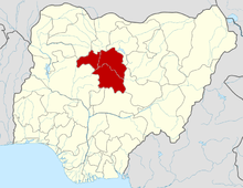 | |