Kâğıthane
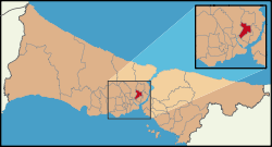
Kâğıthane (Turkish pronunciation: [caˈɯthane]) or Glykà Nerà (Γλυκά Νερά Greek pronunciation: [ɡliˈka neˈra], 'sweet waters') is an area of Istanbul, Turkey. Formerly a working class district, it has become one of the largest real estate development areas in the city. The district is located on the European side and extends over the shores of Cendere, the stream that discharges into the Golden Horn. The Cendere Valley is surrounded by the Sarıyer, Eyüp, Şişli, Beşiktaş, and Beyoğlu districts. The mayor is Fazlı Kılıç of Ak Parti. Kâğıthane was part of Beyoğlu until 1954 and part of Şişli between 1954 and 1987.
Kâğıthane | |
|---|---|
district | |
 Location of Kâğıthane in Istanbul | |
 Kâğıthane Location of Kâğıthane in Istanbul | |
| Coordinates: 41°04′19″N 28°57′59″E | |
| Country | Turkey |
| City | Istanbul |
| Government | |
| • Mayor | Fazlı Kılıç (AKP) |
| • Governor | Ahmet Akın Varıcıer |
| Area | |
| • District | 14.52 km2 (5.61 sq mi) |
| Population (2012)[2] | |
| • District | 421,356 |
| • District density | 29,000/km2 (75,000/sq mi) |
| Time zone | UTC+2 (EET) |
| • Summer (DST) | UTC+3 (EEST) |
| Area code(s) | 0-212 |
| Website | www |

History
In the time of Suleiman the Magnificent Kâğıthane, which was called 'Sadabad', was a large forested land and frequented by the Ottoman court for hunting, riding and all other kind of equestrian activities. In the following centuries, Sadabad became a centre of recreation with its clean waters, tulip fields, promenades and festivities. There are a lot of engravings and paintings depicting gatherings in Sadabad, such as weddings or picnics. Later, in the 17th and 18th centuries, mansions and summer palaces were built in the area.
In the 19th and beginning of the 20th centuries, the strategically and logistically well located area was turned into a zone of industry. Kâğıthane then became home to numerous factories including flour mills and the paper factories. The district was named after these paper factories and came to be called as "Kâğıt hane" (paper house). Although it is known that from time to time gypsies, nomadic people, trade or hadj caravans were hosted in the region, there was no settlement therein until the late 20th century.
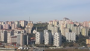
The settlement in Kâğıthane started as illegal slums from the 1950s onwards, as the city received thousands of migrants from Anatolia, who came to work in the factories, building sites or services sector. With the passage of time, the illegal settlements were legalised and gradually replaced by residentially-zoned buildings.
Today
Due to its central location, especially its connections with the new intra-city transport networks, and the entry into force of urban regeneration legislation, Kâğıthane is transforming. To the north, the district will serve as a hub after the completion of the construction of the third airport (new airport), third bridge and three-storey under water tunnel (that will join the European side at the Hasdal junction in the district). Real estate development includes a wide range of mixed-use, shopping mall, hotel, campus, office or residential projects.
The neighbourhoods of Kâğıthane include, among others, Seyrantepe, Hamidiye, Çağlayan, Merkez (centre) and Gültepe.
Landmarks
Transportation
References
- "Area of regions (including lakes), km²". Regional Statistics Database. Turkish Statistical Institute. 2002. Retrieved 2013-03-05.
- "Population of province/district centers and towns/villages by districts - 2012". Address Based Population Registration System (ABPRS) Database. Turkish Statistical Institute. Retrieved 2013-02-27.
