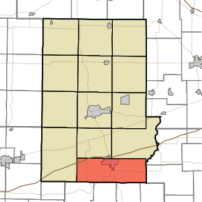
Cloverdale Township, Putnam County, Indiana
Cloverdale Township is one of thirteen townships in Putnam County, Indiana. As of the 2010 census, its population was 3,929 and it contained 1,713 housing units.[3]
Cloverdale Township | |
|---|---|
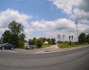 Intersection of U.S. 231 and State Highway 42 in Cloverdale Township | |
 | |
| Coordinates: 39°30′02″N 86°47′41″W | |
| Country | United States |
| State | Indiana |
| County | Putnam |
| Government | |
| • Type | Indiana township |
| Area | |
| • Total | 46.18 sq mi (119.6 km2) |
| • Land | 45.72 sq mi (118.4 km2) |
| • Water | 0.46 sq mi (1.2 km2) |
| Elevation | 794 ft (242 m) |
| Population (2010) | |
| • Total | 3,929 |
| • Density | 85.9/sq mi (33.2/km2) |
| Time zone | UTC-5 (Eastern (EST)) |
| • Summer (DST) | UTC-4 (EDT) |
| Area code(s) | 765 |
| FIPS code | 18-13870[2] |
| GNIS feature ID | 453235 |
Cloverdale Township was organized in 1846.[4]
Geography
According to the 2010 census, the township has a total area of 46.18 square miles (119.6 km2), of which 45.72 square miles (118.4 km2) (or 99.00%) is land and 0.46 square miles (1.2 km2) (or 1.00%) is water.[3]
Cities and towns
- Cloverdale (partial)
gollark: Most people can't influence politics much, so they fairly rationally mostly ignore it and do whatever makes people around them not shun them and whatever sounds nicest.
gollark: In politics this might manifest as "taxation is theft (because I don't particularly want to give the government money but they take it anyway)", or "work is slavery (because you are heavily incentivized to do some amount of work or you struggle to afford things)".
gollark: The issue is that a "book" isn't a strict formal thing but a pointer to a rough fuzzy set of things which we call "books" for convenience.
gollark: For example, if I said "this eBook is a book because it's a long-form piece of verbal content", I could then use the noncentral fallacy to go "so it's made of paper and has text printed onto physical pages".
gollark: X is sort of Y if you stretch the/a definition, so X should have all the connotations of Y.
References
- "US Board on Geographic Names". United States Geological Survey. 2007-10-25. Retrieved 2008-01-31.
- "U.S. Census website". United States Census Bureau. Retrieved 2008-01-31.
- "Population, Housing Units, Area, and Density: 2010 - County -- County Subdivision and Place -- 2010 Census Summary File 1". United States Census. Archived from the original on 2020-02-12. Retrieved 2013-05-10.
- Weik, Jesse William (1910). Weik's History of Putnam County, Indiana. B.F. Bowen. p. 184.
External links
Municipalities and communities of Putnam County, Indiana, United States | ||
|---|---|---|
| City | Map of Indiana highlighting Putnam County | |
| Towns | ||
| Townships | ||
| CDPs | ||
| Other unincorporated communities |
| |
| Footnotes | ‡This populated place also has portions in an adjacent county or counties | |
This article is issued from Wikipedia. The text is licensed under Creative Commons - Attribution - Sharealike. Additional terms may apply for the media files.