Jefferson Township, Noble County, Indiana
Jefferson Township is one of thirteen townships in Noble County, Indiana, United States. As of the 2010 census, its population was 1,604 and it contained 668 housing units.[2]
Jefferson Township | |
|---|---|
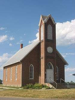 Jefferson Union Church, a historic site in the township | |
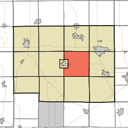 Location in Noble County | |
| Coordinates: 41°23′56″N 85°21′41″W | |
| Country | |
| State | |
| County | Noble |
| Government | |
| • Type | Indiana township |
| Area | |
| • Total | 33.67 sq mi (87.2 km2) |
| • Land | 33.37 sq mi (86.4 km2) |
| • Water | 0.3 sq mi (0.8 km2) 0.89% |
| Elevation | 942 ft (287 m) |
| Population (2010) | |
| • Total | 1,604 |
| • Density | 48.1/sq mi (18.6/km2) |
| Time zone | UTC-5 (Eastern (EST)) |
| • Summer (DST) | UTC-4 (EDT) |
| ZIP codes | 46701, 46710, 46755 |
| Area code(s) | 260 |
| GNIS feature ID | 453493 |
Geography
According to the 2010 census, the township has a total area of 33.67 square miles (87.2 km2), of which 33.37 square miles (86.4 km2) (or 99.11%) is land and 0.3 square miles (0.78 km2) (or 0.89%) is water.[2]
Cities, towns, villages
- Albion (east edge)
Unincorporated towns
(This list is based on USGS data and may include former settlements.)
Lakes
- Bushong Lake
- Indian Lake
- Schauweker Lake
- Skinner Lake
- Sweet Lake
School districts
- Central Noble Community School Corporation
Political districts
- Indiana's 3rd congressional district
- State House District 52
- State Senate District 13
gollark: [æ]+
gollark: Except bits which need to be very high performance, if it has any.
gollark: Mathematica is probably not programmed in assembly, say.
gollark: ... generally, software which actually solves some sort of problem.
gollark: Assembly has a bit of a niche for low-level stuff (so OSes and reverse engineering and stuff which needs to run as fast as possible and whatever), but practical stuff *is mostly not that*, and the majority of the time easier development and maintenance is more significant than that.
References
- "Jefferson Township, Noble County, Indiana". Geographic Names Information System. United States Geological Survey. Retrieved 2009-10-17.
- United States Census Bureau 2008 TIGER/Line Shapefiles
- IndianaMap
- "US Board on Geographic Names". United States Geological Survey. October 25, 2007. Retrieved 2017-05-09.
- "Population, Housing Units, Area, and Density: 2010 - County -- County Subdivision and Place -- 2010 Census Summary File 1". United States Census. Archived from the original on 2020-02-12. Retrieved 2013-05-10.
External links
- Indiana Township Association
- United Township Association of Indiana
- City-Data.com page for Jefferson Township
Places adjacent to Jefferson Township, Noble County, Indiana | |
|---|---|
Municipalities and communities of Noble County, Indiana, United States | ||
|---|---|---|
| Cities | Map of Indiana highlighting Noble County | |
| Towns | ||
| Townships | ||
| CDP | ||
| Unincorporated communities | ||
| Footnotes | ‡This populated place also has portions in an adjacent county or counties | |
This article is issued from Wikipedia. The text is licensed under Creative Commons - Attribution - Sharealike. Additional terms may apply for the media files.