Le Plateau-Mont-Royal
Le Plateau-Mont-Royal (French pronunciation: [lə plato mɔ̃ ʁwajal]) is a borough (arrondissement) of the city of Montreal, Quebec, Canada.
Le Plateau-Mont-Royal | |
|---|---|
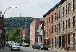 Mount Royal seen from Duluth Street in the Plateau. | |
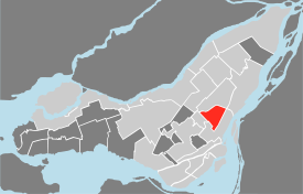 Le Plateau Mont-Royal's location in Montreal | |
| Coordinates: 45°31′18″N 73°34′32″W | |
| Country | |
| Province | |
| City | Montreal |
| Region | Montréal |
| Borough established | January 1, 2002 |
| Electoral Districts Federal | Laurier—Sainte-Marie Outremont Ville-Marie—Le Sud-Ouest—Île-des-Sœurs |
| Provincial | Mercier Outremont Sainte-Marie–Saint-Jacques Westmount–Saint-Louis |
| Government | |
| • Type | Borough |
| • Mayor | Luc Rabouin (PM) |
| • Federal MP(s) | Steven Guilbeault
(LIB) Marc Miller (LIB) Rachel Bendayan (LIB) |
| • Quebec MNA(s) | Ruba Ghazal (QS) Hélène David (PLQ) Manon Massé (QS) Jennifer Maccarone (PLQ) |
| Area | |
| • Land | 8.1 km2 (3.1 sq mi) |
| Population (2016)[6] | |
| • Total | 104,000 |
| • Density | 12,839/km2 (33,250/sq mi) |
| Time zone | UTC−5 (Eastern (EST)) |
| • Summer (DST) | UTC−4 (EDT) |
| Area code(s) | Area code 514/438 |
| Access Routes[7] | |
| Website | https://beta.montreal.ca/le-plateau-mont-royal |
The Plateau-Mont-Royal takes its name from its location on relatively flat terrain north of Sherbrooke Street and downtown, and east of Mont-Royal. The borough is bordered to the north and north-east by the Canadian Pacific Railway tracks; to the west by Hutchison (north of Mount Royal Avenue), Park Avenue (between Mount Royal and Pine Avenue) and University Street (south of Pine Avenue); and to the south by Sherbrooke Street. It is the most densely populated borough in Canada, with 101,054 people living in an 8.1 square kilometre area.
There is a difference between the borough, Plateau-Mont-Royal—a political division of the City of Montreal—and the neighbourhood referred to as "the Plateau". The borough includes not only the Plateau proper, but also the neighbourhoods of Mile End (bounded by Avenue du Mont-Royal to the south and the Avenue Henri-Julien to the east) and Milton Park (bounded by University, Sherbrooke, Saint-Laurent and Pine). Both neighbourhoods are generally considered distinct from the Plateau.
History
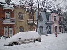
Starting in 1745, the urbanized area of Montreal began to extend beyond its fortifications. The Plateau Mont-Royal was born when the Faubourg Saint-Laurent to the north became the main line of development. In 1792, Montreal expanded to establish its official limits about two kilometres around the original fortifications. Therefore, Mount Royal and Duluth Street formed its boundaries. Farther from the centre, especially to the west, English-speaking families of the era owned large houses surrounded by gardens and the Religious Hospitallers of St. Joseph owned a large field which would be the site of the future Hôtel-Dieu. Further from the city are large country estates whose farms are owned by the Montreal bourgeoisie.
In 1850, a reservoir was installed in what is today the location of Saint-Louis Square. It had the function of supplying water to Côte-à-Baron residents, who lived on the downward slope below Sherbrooke Street. At that time a farm on the site of the current La Fontaine Park was converted into a field of military manoeuvres. To the north, other cities were formed following new economic activity, giving rise to the village of Coteau-Saint-Louis in 1846. A chapel was built two years later to be replaced in 1857 by the Church of Saint-Enfant-Jésus du Mile-End. Nowadays, Mile End is a neighbourhood adjacent to part of the Plateau Mont-Royal, but it was only in 1878 that the village of Saint-Louis-du-Mile-End was born. By the end of the century, the mountain was purchased by the City of Montreal which developed Mount Royal Park. La Fontaine Park took the place of the military field and the reservoir serving Côte-à-Baron gave way to St. Louis Square.
The village of Saint-Jean-Baptiste formed circa 1861. Its central point is also the location of the market (the first market was built in 1870 and replaced by a more modern market in 1933, which was demolished in 1966). The civic centre was located at the intersection of Saint Lawrence Street (later Saint Laurent Boulevard) and Rachel Street. The villages of Coteau-Saint-Louis and Saint-Jean-Baptiste merged into Montreal in 1893 and 1886 respectively. As for Saint-Louis-du-Mile-End and DeLorimier, they would be annexed to Montreal in 1910 and 1909 respectively. At that time, the population of Montreal spilled over east of Papineau Road (today Papineau Avenue), where elegant houses and avenues were located.
In the early twentieth century, it was a working class neighbourhood. Over the years, spurred by economic growth, the working class population gradually deserted the area. By 1900, Coteau-Saint-Louis had become very cosmopolitan, and counted several Protestant churches and synagogues. Several Protestant traders opened shop on St. Lawrence Street (renamed St. Lawrence Boulevard in 1905). St. Lawrence was the linguistic border between the French-speaking east, and English-speaking west. At that time, Saint Joseph Boulevard became the first tree-lined street in the city.
In the 1930s, the Great Depression slowed construction in the district, although some work resulted in the funding for the landscaping of Sir Wilfrid Laurier Park. The Université de Montréal moved to the northern slope of Mount Royal in 1943, resulting in the relocation of both the English and French bourgeoisie to this neighbourhood. Immigrants settled increasingly in the neighbourhood in the post-war period. Jews operated several boutiques on St. Lawrence Boulevard and moved into the adjacent neighbourhoods to the west. Schwartz's Montreal Hebrew Delicatessen, established in 1928, is still one of the most famous shops in Montreal, famous for its Montreal-style smoked meat sandwiches. Greek Canadians set up many businesses in the decades that followed, particularly along Park Avenue and contributed to the local art of baking and pastry. More recently, Vietnamese and Portuguese settled in the area, as evidenced, for the latter, by Little Portugal.
In the 1980s, the area's bohemian aura and proximity to McGill University attracted gentrification. As rents increased, many of its traditional residents and businesses were dispersed to other parts of the city. The neighbourhood continues to gentrify, and it is now home to many upscale restaurants and nightclubs, and several trendy clothing stores are located along St. Laurent Blvd. and St. Denis St.
Geography
The borough is located northeast of downtown, and was part of the City of Montreal prior to the 2002 municipal mergers.
It is bordered to the south by Ville-Marie, to the west by Outremont, and to the north and east by Rosemont–La Petite-Patrie. Clockwise from the south, it is bounded by Sherbrooke St., University St., Pine Ave. (av. des Pins), Park Ave. (Avenue du Parc), the southward projection of Hutchison St., Hutchison St., and the CP railroad tracks.
Arts and culture
The Plateau began as a bourgeois community with parts of its extensions as working-class developing around the beginning of the 20th century; the Eastern part being largely Québécois, and the Western part primarily European with a total visible minority estimated at 17%.[8] The neighbourhood was the childhood home of Quebec writers Michel Tremblay and Mordecai Richler and both have set many stories in the Plateau of the 1950s and 60s. The Plateau is currently a creative family oriented upper-middle-class neighbourhood. Although the Eastern part is still largely Québécois, the Plateau (now nicknamed "La Nouvelle-France") is emerging as a French enclave of those fleeing Paris' transitioning cultural climate.[9]
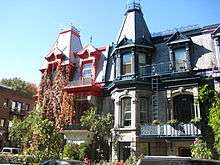
The Plateau is characterized by brightly coloured houses, cafés, book shops, and a laissez-faire attitude that embraces its bohemian nature over the commercialized hipster culture of its Mile-End counterpart.[10] It's the location of some famous attractions on Saint Laurent Boulevard, including Schwartz's Deli (famous for its Montreal smoked meat), and a weekend street fair during the summer that sees extremely crowded streets. In 1997, Utne Reader rated it one of the 15 "hippest" neighbourhoods in North America.[11]
Demographics
| Year | Pop. | ±% |
|---|---|---|
| 1966 | 176,090 | — |
| 1971 | 158,585 | −9.9% |
| 1976 | 135,490 | −14.6% |
| 1981 | 113,866 | −16.0% |
| 1986 | 106,569 | −6.4% |
| 1991 | 100,375 | −5.8% |
| 1996 | 99,575 | −0.8% |
| 2001 | 101,364 | +1.8% |
| 2006 | 101,054 | −0.3% |
| 2011 | 100,390 | −0.7% |
| 2016 | 104,000 | +3.6% |
| [12] | ||
| Language | Population | Percentage (%) |
|---|---|---|
| French | 65,715 | 67.32% |
| English | 22,230 | 22.77% |
| Other languages | 9,670 | 9.91% |
The plateau has the highest concentration of youths living there, with an average age of 34, and an overall average age range of 25–34 years old. The average number of people per household is 1.7. 53% live alone. In 2011, approximately half of the families living in the plateau have no children.
As of the 2011 census, 49% of the people living in the Plateau had immigrated from elsewhere, or their parents had migrated from outside of Montreal. A majority of the immigrants were found to be from France and Portugal. In addition, 16% of its occupants belong to visible minority groups.
The average income for individuals living in this area is $37,500, and average income for a household is $56,072. Families make an average income of $83,803. Single parent families have an average annual income of $52,683.
Government
Borough council
Following the November 5, 2017 Montreal municipal election and an October 6, 2019 by-election for borough mayor,[14] the current borough council consists of the following councillors:
| District | Position | Name | Party | |
|---|---|---|---|---|
| — | Borough mayor City councillor |
Luc Rabouin | Projet Montréal | |
| De Lorimier | City councillor | Marianne Giguère | Projet Montréal | |
| Borough councillor | Josefina Blanco | Projet Montréal | ||
| Jeanne-Mance | City councillor | Alex Norris | Projet Montréal | |
| Borough councillor | Maeva Vilain | Projet Montréal | ||
| Mile-End | City councillor | Richard Ryan | Projet Montréal | |
| Borough councillor | Marie Plourde | Projet Montréal |
Federal and provincial
The borough is divided among the following federal ridings:
- Outremont
- Ville-Marie—Le Sud-Ouest—Île-des-Sœurs
- Laurier—Sainte-Marie (the bulk of the borough is in this riding)
It is divided among the following provincial electoral districts:
- Outremont
- Mercier
- Hochelaga-Maisonneuve (a small southeastern corner)
- Sainte-Marie–Saint-Jacques
- Westmount–Saint-Louis
Education
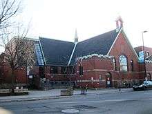
The Commission scolaire de Montréal (CSDM) operates Francophone public schools and the English Montreal School Board (EMSB) operates Anglophone public schools in the borough. The two school boards jointly operate F.A.C.E. School, a bilingual art-oriented school located in the Milton Park neighbourhood.
McGill University maintains a significant presence in the borough, including four residence halls, Presbyterian College and the Steinberg Centre for Simulation and Interactive Learning.
The borough has two libraries of the Montreal Public Libraries Network: Mile End and Plateau-Mont-Royal.[15]
Features
Overlooked by the eastern face of Mount Royal, the borough is served by part of the orange line of the Montreal metro, including Sherbrooke, Mont-Royal, and Laurier stations.
Important features of the borough include the Hôtel-Dieu de Montréal, Lafontaine Park, and Jeanne Mance Park.
The borough is largely composed of the well-known Plateau neighbourhood, famous for its bohemian reputation and characteristic architecture. The neighbourhoods of Mile End, Côte Saint-Louis, and Milton-Parc (including the McGill Ghetto) are also located in the borough.
Montreal's Little Portugal neighbourhood is situated in the western portion of the borough.
Le Plateau-Mont-Royal borough council has undertaken various renaturalisation and traffic-calming projects in recent years under the leadership of borough Mayor Luc Ferrandez. The reconstruction of intersections now usually involves constructing road-diets (where vehicular traffic space has been reduced) in favour of wider sidewalks and large naturalised areas with grasses, flowers and other indigenous plant species. The renaturalisation of some alleyways has been realised through the removal of asphalt or concrete along the edge of property lines for soil; local residents can plant whatever they choose. Many streets underwent one-directional reassignments, to the irritation of local and visiting motorists; Ferrandez has faced criticism for what some feel to be drastic changes resulting in decreased vehicular and pedestrian traffic for merchants on main thoroughfares.[16]
See also
| Wikimedia Commons has media related to Le Plateau-Mont-Royal. |
- Boroughs of Montreal
- Districts of Montreal
- Municipal reorganization in Quebec
References
- Ministère des Affaires Municipales et Régions: Le Plateau-Mont-Royal
- Parliament of Canada Federal Riding History: LAURIER--SAINTE-MARIE (Quebec)
Parliament of Canada Federal Riding History: OUTREMONT (Quebec)
Parliament of Canada Federal Riding History: WESTMOUNT--VILLE-MARIE (Quebec) - Chief Electoral Officer of Québec - 40th General Election Riding Results: MERCIER
Chief Electoral Officer of Québec - 40th General Election Riding Results: OUTREMONT
Chief Electoral Officer of Québec - 40th General Election Riding Results: SAINTE-MARIE-SAINT-JACQUES
Chief Electoral Officer of Québec - 40th General Election Riding Results: HOCHELAGA-MAISONNEUVE
Chief Electoral Officer of Québec - 40th General Election Riding Results: WESTMOUNT-SAINT-LOUIS - www.ville.montreal.qc.ca/plateau
- "Population totale en 2006 et en 2011 - Variation — Densité" (PDF). Canada 2011 Census (in French). Ville de Montréal. 2012. Retrieved 5 June 2012.
- "Montréal en Statistiques 2016" (PDF). Ville de Montréal. Retrieved 21 January 2018.
- Official Transport Quebec Road Map
- http://ville.montreal.qc.ca/pls/portal/docs/PAGE/MTL_STATS_FR/MEDIA/DOCUMENTS/PROFIL_SOCIOD%C9MO_PLATEAU%20MONT-ROYAL%202016.PDF
- https://montrealgazette.com/opinion/columnists/josh-freed-french-emigres-swarm-the-plateau-to-escape-woes-in-europe
- https://www.cbc.ca/news/canada/montreal/ubisoft-20-years-montreal-mile-end-2017-1.4143407
- http://www.utne.com/1997-11-01/hip-hot-spots.aspx?page=2#axzz2Z0T0mdTQ
- "Profil sociodéographique: Arrondissement Le Plateau Mont-Royal" (PDF) (in French). Ville de Montréal. 2013. Retrieved 28 October 2013.
- http://ville.montreal.qc.ca/portal/page?_pageid=6897,68087646&_dad=portal&_schema=PORTAL
- Ruel-Manseau, Audrey (7 October 2019). "Luc Rabouin succède à Luc Ferrandez". La Presse. Retrieved 7 October 2019.
- "Les bibliothèques par arrondissement." Montreal Public Libraries Network. Retrieved on December 7, 2014.
- Perreaux, Les (31 December 2015). "Montreal's battle of the bike paths in Plateau Mont-Royal". The Globe and Mail. Toronto.
External links
| Wikivoyage has a travel guide for The Plateau. |