Interstate 410
Interstate 410 (abbreviated I-410, and colloquially called Loop 410) is a loop route of Interstate 10 around San Antonio, Texas. It is identified as Connally Loop in honor of former Texas governor John Connally.
| ||||
|---|---|---|---|---|
| Connally Loop | ||||

I-410 highlighted in red | ||||
| Route information | ||||
| Auxiliary route of I-10 | ||||
| Maintained by TxDOT | ||||
| Length | 49.49 mi[1] (79.65 km) | |||
| Existed | 1959[2]–present | |||
| Major junctions | ||||
| Beltway around San Antonio | ||||
| Location | ||||
| Counties | Bexar | |||
| Highway system | ||||
| ||||
.svg.png)
Route description
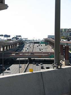
Interstate 410 circumnavigates the city of San Antonio, officially beginning and ending at the junction with Interstate 35 on the southwest side of the loop. There are vast differences between the northern arc and southern arc of the loop. The northern arc serves the heavily urbanized portions of San Antonio and is currently being upgraded to as many as five lanes in each direction. The southern arc resembles more of a rural interstate as it transverses for the most part undeveloped portions of San Antonio as a two lane interstate. I-410 intersects I-10 twice, I-35 twice, I-37 once, as well as U.S. Highway 90, US 281, and State Highway 151, all freeways in the San Antonio metro area with the exception of Loop 1604, which forms a secondary loop around the city, and PA 1502 (Wurzbach Parkway), which is located about 2 miles outside the loop on the north side. I-410 serves San Antonio International Airport, Lackland AFB, Fort Sam Houston, South Texas Medical Center, Southwest Research Institute, and Toyota Motor Manufacturing Texas.[3]
History

Like most cities in Texas, San Antonio was served by a loop around the city long before the arrival of the Interstate Highway System. Loop 13, although not a freeway, served in this role up until the 1950s, when many of San Antonio's freeways were constructed. The northern half of Loop 13 followed the current path of I-410 while the southern half still exists on the south side of San Antonio. Much of the freeway was proposed during the mid-1950s with construction beginning on the northwest portion of the loop near I-10. On October 15, 1960, Loop 13 from I-10 to I-35 was redesignated as Loop 410 for continuity purposes. By 1961 the freeway had been completed from I-35 on the southwest side to just east of US 281 near the airport where it continued once to the east as a 4-lane highway to I-35. By 1964 the southern arc had been extended eastward from I-35 to Roosevelt Avenue and was under construction from Roosevelt to I-35 on the east side of the city. By 1967 the eastern arc had been completed to Interstate Highway standards and the remaining portion from US 281 to I-35 on the cities north side had been completely upgraded to Interstate Highway standards, but still carried the State Loop 410 designation until July 31, 1969 when it officially became Interstate 410.[2]
Due to the city growing primarily to the north, I-410 required upgrading along this stretch. It was expanded to six lanes in the late 1970s and early 1980s from Ingram Road to I-35 North. It was further expanded to six lanes from Ingram to Valley Hi Road in 1987. An additional westbound lane was added from I-10 West to Babcock Road in 1996.
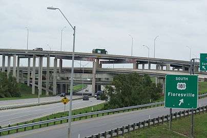
I-410 was widened from the late 1990s through early 2010s along its entire northern arc from Culebra Road to Austin Highway, with five lanes each way and intersection upgrades at I-10 and San Pedro, and an entire new interchange at US 281.,[4][5] officially called the "San Antonio Web".[6]
Exit list
Exit numbers correspond to mileage from the south junction with I-35.[3] The entire highway is in Bexar County.
| Location | mi | km | Exit | Destinations | Notes | |
|---|---|---|---|---|---|---|
| San Antonio | 0.75 | 1.21 | 1 | Frontage Road | ||
| 1.88 | 3.03 | 2 | ||||
| 3.47 | 5.58 | 3A | Ray Ellison Boulevard | Signed as exit 3 northbound | ||
| 4.23 | 6.81 | 3B | Medina Base Road | Northbound exit is via exit 3 | ||
| 4.93 | 7.93 | 4 | Valley Hi Drive – Lackland AFB | |||
| 6.18 | 9.95 | 6 | ||||
| 7.61 | 12.25 | 7 | Marbach Road | Signed as exit 8 southbound | ||
| 8.80 | 14.16 | 9A | Signed as exit 9 northbound | |||
| 9.51 | 15.30 | 9B | West Military Drive | Southbound exit and northbound entrance | ||
| 10.41 | 16.75 | 10 | Culebra Road | Former FM 3487 | ||
| 11.53 | 18.56 | 11 | Ingram Road | |||
| 12.84 | 20.66 | 12 | Exchange Parkway | Southbound exit and entrance | ||
| 13.16 | 21.18 | 13A | North end of SH 16 concurrency; signed as exits 13A and 13B (north) westbound | |||
| 13.62 | 21.92 | 13B | Evers Road | Westbound exit and eastbound entrance; westbound is via exit 14A | ||
| 14.30 | 23.01 | 14A | Summit Parkway | Westbound exit and entrance | ||
| 14.80 | 23.82 | 14B | Callaghan Road | Signed as exit 14 eastbound | ||
| 15.21 | 24.48 | 14C | Eastbound exit is via exit 14, access to South Texas Medical Center | |||
| 16.08 | 25.88 | 15 | Access to South Texas Medical Center and Methodist Texan Hospital | |||
| 16.69 | 26.86 | 16 | I-10 exit 564 | |||
| 17.19 | 27.66 | 17A | Cherry Ridge Drive | Eastbound exit and westbound entrance, westbound exit is via exit 17 | ||
| 17.82 | 28.68 | 17B | Vance Jackson Road | Signed as exit 17 westbound | ||
| Castle Hills | 18.37– 18.50 | 29.56– 29.77 | 18 | Jackson-Keller Road, West Avenue | ||
| 18.92 | 30.45 | 19A | Honeysuckle Lane | Eastbound exit is via exit 18 | ||
| 19.34 | 31.12 | 19B | Signed as exit 19 eastbound | |||
| 19.70 | 31.70 | 19 | Westbound exit is via exit 20A | |||
| San Antonio | 20.15 | 32.43 | 20A | Signed as exit 20 eastbound | ||
| 20.60 | 33.15 | 20B | McCullough Avenue | Eastbound exit is via exit 20 | ||
| 21.31 | 34.30 | 21A | "San Antonio Web", fully opened June 9, 2008[5] | |||
| 21.49– 21.96 | 34.58– 35.34 | 21 | Signed as exit 21B eastbound | |||
| 22.27 | 35.84 | 22 | Broadway Street | No eastbound entrance | ||
| 23.02 | 37.05 | 23 | Nacogdoches Road | No westbound entrance, westbound exit is via exit 24 | ||
| 23.83 | 38.35 | 24 | Harry Wurzbach Road – Fort Sam Houston | |||
| 24.78 | 39.88 | 25A | Signed as exit 25 eastbound, access to Northeast Baptist Hospital | |||
| 25.49 | 41.02 | 25B | Eastbound exit is via exit 25 | |||
| 25.98 | 41.81 | 26A | Signed as exit 26 westbound | |||
| 26.50 | 42.65 | 26B | Interchange Parkway, Perrin Creek Drive | Eastbound exit and westbound entrance | ||
| 26.60 | 42.81 | 27 | North end of I-35 concurrency; signed as exit 166 northbound; freeway assumes I-35's exit numbers | |||
| 26.70 | 42.97 | 166A | Randolph Boulevard – Windcrest | Northbound exit and westbound entrance | ||
| 27.22 | 43.81 | 165 | ||||
| 28.19 | 45.37 | 164B | Eisenhauer Road | |||
| 29.82 | 47.99 | 163 | South end of I-35 concurrency; southbound exit and northbound entrance | |||
| 29.07 | 46.78 | 30 | Rittiman Road, Space Center Drive | Northbound exit and entrance | ||
| 30.71 | 49.42 | 30 | Binz-Engleman Road | Southbound exit and northbound entrance | ||
| 30.77 | 49.52 | 31A | Signed as exit 32 northbound | |||
| 31.35 | 50.45 | 31 | Northbound left exit and southbound entrance | |||
| 31.58 | 50.82 | 31B | No northbound exit | |||
| 32.35 | 52.06 | 32 | Dietrich Road | Southbound exit only | ||
| 32.79 | 52.77 | 33 | North end of SH 130 concurrency; I-10 exit 581 | |||
| 33.66 | 54.17 | 34 | ||||
| 35.39 | 56.95 | 35 | ||||
| 37.22 | 59.90 | 37 | Southcross Boulevard/New Sulphur Springs Road, Sinclair Road | |||
| 38.54 | 62.02 | 39 | ||||
| 40.54 | 65.24 | 41 | East end of US 281 concurrency; I-37 exit 133, access to Mission Trail Baptist Hospital | |||
| 41.29 | 66.45 | 42 | ||||
| 43.21 | 69.54 | 43 | Espada Road – San Antonio Missions National Historical Park | Westbound exit is via exit 44 | ||
| 44.37 | 71.41 | 44 | West end of US 281 concurrency | |||
| 45.94 | 73.93 | 46 | Moursund Boulevard | |||
| 47.22 | 75.99 | 47 | University Way – Texas A&M University–San Antonio | East exit and east entrance | ||
| 47.69 | 76.75 | 48 | Zarzamora Street | |||
| 48.92 | 78.73 | 49 | East end of SH 16 concurrency | |||
| 51.32 | 82.59 | 51 | ||||
| 52.30 0.00 | 84.17 0.00 | 53 | South end of SH 130 concurrency; I-35 exit 145A | |||
1.000 mi = 1.609 km; 1.000 km = 0.621 mi
| ||||||
References
| Wikimedia Commons has media related to Interstate 410 (Texas). |
- Federal Highway Administration. "Route Log – Auxiliary Routes of the Eisenhower National System of Interstate and Defense Highways – Table 2". Retrieved February 26, 2008.
- Transportation Planning and Programming Division (n.d.). "Interstate Highway No. 410". Highway Designation Files. Texas Department of Transportation. Retrieved February 26, 2008.
- Google (February 24, 2008). "overview map of I-410" (Map). Google Maps. Google. Retrieved February 24, 2008.
- Driscoll, Patrick (June 19, 2007). "Decades in waiting, ramp open". San Antonio Express-News. Archived from the original on September 29, 2007. Retrieved February 26, 2008.
- Driscoll, Patrick (June 10, 2008). "U.S. 281/Loop 410 interchange ramps are complete". San Antonio Express-News. Archived from the original on June 11, 2008. Retrieved June 20, 2008.
- Driscoll, Patrick (January 16, 2006). "Now there's a name for it". San Antonio Express-News. Archived from the original on February 23, 2008. Retrieved June 20, 2008.