Texas State Highway Spur 117
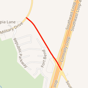
Spur 117 is a 0.546-mile-long (879 m) spur route in the U.S. state of Texas that connects Interstate 410 (I-410) and Loop 13 in San Antonio in Bexar County. The road is maintained by the Texas Department of Transportation (TxDOT). The spur was designated in 1980 and follows W.W. White Road from I-410 on the southeast side of San Antonio towards the northwest ending at Loop 13.
| ||||
|---|---|---|---|---|
| W.W. White Road | ||||

Spur 117 highlighted in red | ||||
| Route information | ||||
| Length | 0.546 mi[1] (0.879 km) | |||
| Existed | 1980–present | |||
| Major junctions | ||||
| South end | ||||
| North end | ||||
| Location | ||||
| Counties | Bexar | |||
| Highway system | ||||
| ||||
The route number was previously designated as a short former spur at Mount Calm.
History
Hill County
Spur 117 was originally designated on February 4, 1941 as a spur connecting the town of Mount Calm 0.55 miles (890 m) to SH 31 in Hill County.[1] That designation ended on February 21, 1952 when the former Spur 117 was incorporated into FM 1662 as an extension to that route.[2] That route was combined with FM 737 on November 13, 1953,[3] which in turn became an extension of the present FM 339 on July 15, 1971.[4]
Bexar County
Spur 117 was designated on April 14, 1980 along a stretch of road that had not previously held a state highway designation.[1] Spur 117 was proposed for decommissioning in 2014 as part of TxDOT's San Antonio turnback proposal, which would have turned back over 129 miles of roads to the city of San Antonio, but the city of San Antonio said no to that proposal.[5]
Route description
Spur 117 begins at a junction with I-410 on the southeast side of San Antonio. The spur heads northwest along W.W. White Road for 0.55 miles (890 m) before ending at Loop 13 (Military Drive). It is at this point where Loop 13 changes direction from heading east and west to north and south. W.W. White Road continues towards the north, but carries the Loop 13 designation instead.[6]
Major intersections
The entire route is in San Antonio, Bexar County.
| mi[6] | km | Destinations | Notes | ||
|---|---|---|---|---|---|
| 0 | 0.0 | I-410 exit 39; southern terminus. | |||
| 0.5 | 0.80 | Northern terminus. | |||
| 1.000 mi = 1.609 km; 1.000 km = 0.621 mi | |||||
References
- Transportation Planning and Programming Division (n.d.). "State Highway Spur No. 117". Highway Designation Files. Texas Department of Transportation. Retrieved February 24, 2008.
- Transportation Planning and Programming Division (n.d.). "Farm to Market Road No. 1662". Highway Designation Files. Texas Department of Transportation. Retrieved August 3, 2010.
- Transportation Planning and Programming Division (n.d.). "Farm to Market Road No. 737". Highway Designation Files. Texas Department of Transportation. Retrieved August 3, 2010.
- Transportation Planning and Programming Division (n.d.). "Farm to Market Road No. 339". Highway Designation Files. Texas Department of Transportation. Retrieved August 3, 2010.
- https://www.expressnews.com/news/local/article/City-officials-say-no-to-TxDOT-turnback-program-4997151.php. Missing or empty
|title=(help) - Google (August 3, 2010). "Route of Spur 117" (Map). Google Maps. Google. Retrieved August 3, 2010.
