Illinois Route 47
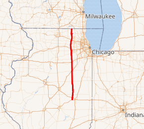
Illinois Route 47 (IL 47) is a 169.76-mile-long (273.20 km) largely rural north–south state highway that runs from the Wisconsin state border at Highway 120 near Hebron, to IL 10, just south of Interstate 72 (I-72) near Seymour.[1] IL 47 is in primarily rural areas but in several suburbs of Chicago, such as Woodstock, traffic can be heavily congested.
| ||||
|---|---|---|---|---|

IL 47 highlighted in red | ||||
| Route information | ||||
| Maintained by IDOT | ||||
| Length | 169.76 mi[1] (273.20 km) | |||
| Existed | 1924[2]–present | |||
| Major junctions | ||||
| South end | ||||
| North end | ||||
| Location | ||||
| Counties | Champaign, Ford, Livingston, Grundy, Kendall, Kane, McHenry | |||
| Highway system | ||||
| ||||
IL 47 crosses most interstate highways in northern and central Illinois, but the largest towns that it serves are Huntley (at the Jane Addams Memorial Tollway), Yorkville (at U.S. Route 34 (US 34)), Woodstock (at US 14), Lily Lake at (IL 64), Elburn (at Illinois Route 38), Sugar Grove (at US 30), Morris (at Interstate 80), Dwight (at I-55), Forrest (at US 24), Gibson City (at IL 54), and Mahomet (at I-74).
Route description
Illinois 47 overlaps Illinois Route 72 and U.S. Route 20 at Pingree Grove, a village approximately 60 miles (97 km) from Chicago; this concurrency is part of a so-called wrong-way concurrency, where one can be driving both west on Illinois 72 and east on U.S. 20 at the same time. Route 47 also shares concurrencies with Illinois Route 9 and Illinois 54 in Gibson City, U.S. Route 30 in Sugar Grove, U.S. Route 6 in Morris, Historic U.S. Route 66 in Dwight, and U.S. Route 150 in Mahomet.
Future
The Illinois Department of Transportation is proposing to add lanes to several portions of Illinois Route 47, which eventually would make it a 4-lane road from I-80 in Morris to I-88 in Sugar Grove, and from I-90 in Huntley to north of Woodstock. A project to reconstruct the road to 4 lanes from Kreutzer Road to Reed Road through Huntley was completed in October 2011.[3] The Prairie Parkway study included engineering for 4 lanes from I-80 in Morris to Caton Farm Road south of Yorkville, and construction was underway of this section as of 2015. Engineering studies are underway for sections of Illinois Route 47 from Caton Farm Road to Illinois 71 in Yorkville, from Kennedy Road in Yorkville to US 30 in Sugar Grove, and from Charles Road to US 14 in Woodstock. A project providing additional lanes from Illinois 71 to Kennedy Road in Yorkville was completed in 2015.
Major intersections
| County | Location | mi[4] | km | Destinations | Notes |
|---|---|---|---|---|---|
| Champaign | | 0.0 | 0.0 | ||
| | 0.5 | 0.80 | I-72 exit 176 | ||
| Mahomet | 5.4 | 8.7 | South end of US 150 overlap | ||
| 5.8 | 9.3 | North end of US 150 overlap | |||
| 6.3 | 10.1 | I-74 exit 172 | |||
| | 14.3 | 23.0 | |||
| Ford | Gibson City | 24.6 | 39.6 | South end of IL 9 / IL 54 overlap | |
| 25.1 | 40.4 | North end of IL 54 overlap | |||
| 25.7 | 41.4 | North end of IL 9 overlap | |||
| Sibley | 34.3 | 55.2 | |||
| Livingston | Forrest | 45.7 | 73.5 | ||
| Saunemin | 55.5 | 89.3 | |||
| Dwight | 69.6 | 112.0 | |||
| 69.9 | 112.5 | South end of Historic US 66 overlap | |||
| 70.4 | 113.3 | North end of Historic US 66 overlap | |||
| Grundy | 71.3 | 114.7 | I-55 exit 220 | ||
| | 82.9 | 133.4 | |||
| Morris | 87.7 | 141.1 | Morris Bridge over Illinois River | ||
| 89.0 | 143.2 | South end of US 6 overlap | |||
| 89.7 | 144.4 | North end of US 6 overlap | |||
| 90.1 | 145.0 | I-80 exit 112 | |||
| Kendall | | 98.6 | 158.7 | ||
| Yorkville | 106.5 | 171.4 | |||
| 107.5 | 173.0 | ||||
| 109.1 | 175.6 | ||||
| Kendall–Kane county line | 113.6 | 182.8 | South end of US 30 overlap | ||
| Kane | Sugar Grove | 116.7 | 187.8 | Interchange; north end of US 30 overlap | |
| Kaneville | 120.8 | 194.4 | I-88 exit 109; I-Pass only on eastbound entrance and exit ramps | ||
| Elburn | 125.4 | 201.8 | |||
| 126.9 | 204.2 | ||||
| Lily Lake | 129.5 | 208.4 | |||
| Pingree Grove | 139.9 | 225.1 | South end of US 20 / IL 72 overlap | ||
| Starks | 140.4 | 226.0 | North end of US 20 / IL 72 overlap | ||
| Huntley | 143.3 | 230.6 | I-Pass only; I-90 exit 47 | ||
| McHenry | | 152.0 | 244.6 | South end of IL 176 overlap | |
| | 152.7 | 245.7 | North end of IL 176 overlap | ||
| Woodstock | 155.5 | 250.3 | |||
| 157.4 | 253.3 | ||||
| Hebron | 168.1 | 270.5 | |||
| | 169.76 | 273.20 | Wisconsin state line | ||
1.000 mi = 1.609 km; 1.000 km = 0.621 mi
| |||||
External links
References
- Illinois Technology Transfer Center (2006). "T2 GIS Data". Retrieved 2007-11-08.
- Carlson, Rick. Illinois Highways Page: Routes 41 thru 60. Last updated March 15, 2006. Retrieved March 28, 2006.
- Village of Huntley IL 47 website Retrieved 3-9-11
- Google Maps,
