U.S. Route 6 in Illinois
U.S. Route 6 (US 6) in the state of Illinois is an east–west arterial surface road that runs 179.88 miles (289.49 km) from the city of Moline in the Quad Cities area to Lansing at the Indiana state line.
| ||||
|---|---|---|---|---|
| Grand Army of the Republic Highway | ||||
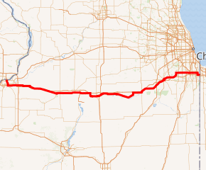
US 6 highlighted in red | ||||
| Route information | ||||
| Maintained by IDOT | ||||
| Length | 179.88 mi[1] (289.49 km) | |||
| Existed | 1932[2]–present | |||
| Major junctions | ||||
| West end | ||||
| East end | ||||
| Location | ||||
| Counties | Rock Island, Henry, Bureau, LaSalle, Grundy, Will, Cook | |||
| Highway system | ||||
| ||||

Route description
In Illinois, U.S. Route 6 can be split into the following sections:
Quad Cities to LaSalle–Peru
U.S. Route 6 crosses the I-74 Bridge from Bettendorf, Iowa south into Moline, concurrent with Interstate 74. It remains with Interstate 74 for 5 miles (8 km) until the intersection with Interstate 280 south of the Rock River. U.S. 6 then turns east at the Quad Cities International Airport. It intersects Interstate 80 as it leaves the Quad Cities area, and closely parallels I-80 for the rest of its length in Illinois.
From the Quad Cities, U.S. 6 travels east through the city of Geneseo. At Sheffield, U.S. 6 overlaps U.S. Route 34 through to Princeton. After an interchange with Interstate 180, U.S. 6 runs with Illinois Route 89 to Spring Valley. In the LaSalle-Peru area, U.S. 6 intersects with Illinois Route 251, U.S. Route 51 and Interstate 39.
LaSalle–Peru to Joliet
U.S. 6 then runs past Ottawa, intersecting with the concurrent Illinois Routes 23/71 before joining with Illinois 71 for 4 miles (6 km). Further east, U.S. 6 runs through Marseilles and Seneca, where Illinois Route 170 terminates. It then runs through Morris and overlaps Illinois Route 47 for a slight northward jog. At Channahon, U.S. 6 has an interchange with Interstate 55.
Joliet to Indiana
In the Joliet area, U.S. 6 parallels the Des Plaines River and passes beneath the cantilever bridge carrying Interstate 80 over the Des Plaines River. At this point it is called Railroad Street, but it turns onto McDonough Street with U.S. Route 52 as it crosses the river. It then turns north, overlapping Illinois Route 53 (Chicago Street) and then east with U.S. Route 30 (Cass Street). Two blocks north of leaving U.S. 30, U.S. 6 intersects the southern terminus of Illinois Route 171 and turns east onto Maple Road. In New Lenox it intersects with Interstate 355 and becomes the Southwest Highway.
U.S. 6 turns off the Southwest Highway west of Orland Park and becomes 159th Street, a major east–west arterial through that town and the southern suburbs of Chicago. In Calumet City, U.S. 6 joins with Illinois Route 83 south to the Interstates 80/94 (Kingery Expressway), and then follows the Kingery east into Indiana.
On this routing, U.S. 6 (like nearby U.S. 30) never enters the city limits of Chicago.
History
U.S. 6 first was shown on maps in 1932, mainly on its current routing except for a more southerly routing from Princeton to Spring Valley through De Pue and at the Illinois/Indiana line. In 1934 it was changed to its current routing from Princeton to Spring Valley. In 1966, the eastern border in Illinois was moved onto the Kingery Highway.[2] The old routing became Business U.S. Route 6 east to Interstate 65. Business U.S. 6 existed in Illinois until the 1970s.
Prior to the formation of US 6, the road west of Princeton was U.S. Route 32. US 32 remained for several more years until the part east of Princeton became an extension of U.S. Route 34.
Major intersections
| County | Location | mi[1][3] | km | Destinations | Notes | ||
|---|---|---|---|---|---|---|---|
| Rock Island | Moline | 0.0 | 0.0 | Iowa state line (I-74 Bridge over the Mississippi River) | |||
| see I-74 (exits 1-5) | |||||||
| 4.5 | 7.2 | Eastern end of I-74 overlap; signed as exit 5A (I-280 west) | |||||
| 27th Street / Quad City Airport - Rock Island | 27th Street is state maintained | ||||||
| 5.4 | 8.7 | ||||||
| Henry | | 12.0 | 19.3 | ||||
| Colona | 13.1 | 21.1 | I-80 exit 9 | ||||
| | Green River-Osco Road - Green River, Osco | former US 6 west; state maintained | |||||
| Geneseo | 22.7 | 36.5 | Western end of IL 82 overlap | ||||
| 23.5 | 37.8 | Eastern end of IL 82 overlap | |||||
| Atkinson | former IL 82 spur; state maintained | ||||||
| Annawan | 36.9 | 59.4 | |||||
| Bureau | | 45.2 | 72.7 | Western end of US 34 overlap | |||
| | 49.0 | 78.9 | |||||
| Princeton | 60.6 | 97.5 | Eastern end of US 34 overlap; western end of IL 26 overlap; former IL 89 spur to Tiskilwa (state maintained outside Princeton) | ||||
| 61.3 | 98.7 | Eastern end of IL 26 overlap | |||||
| | 64.9 | 104.4 | I-180 exit 3 | ||||
| | Depue Road - DePue | former US 6 east; state maintained | |||||
| Spring Valley | 73.6 | 118.4 | Western end of IL 89 overlap | ||||
| 75.6 | 121.7 | ||||||
| 76.8 | 123.6 | Eastern end of IL 89 overlap | |||||
| La Salle | Peru | 81.0 | 130.4 | interchange | |||
| La Salle | 82.3 | 132.4 | Western end of IL 351 overlap | ||||
| 82.5 | 132.8 | Eastern end of IL 351 overlap | |||||
| | 83.8 | 134.9 | I-39 exit 57 | ||||
| | 87.7 | 141.1 | |||||
| Ottawa | 96.8 | 155.8 | Western end of IL 71 overlap | ||||
| | 99.0 | 159.3 | Eastern end of IL 71 overlap | ||||
| Seneca | 109.7 | 176.5 | |||||
| Grundy | Morris | 121.7 | 195.9 | Western end of IL 47 overlap | |||
| 122.4 | 197.0 | Eastern end of IL 47 overlap | |||||
| Will | Channahon | 136.2 | 219.2 | I-55 exit 248 | |||
| | 140.9 | 226.8 | |||||
| Joliet | 143.2 | 230.5 | Western end of US 52 overlap | ||||
| 143.7 | 231.3 | Eastern end of US 52 overlap; western end of IL 53 / Historic US 66 overlap | |||||
| eastern end of IL 53 / Historic US 66 overlap; western end of US 30 / Lincoln Highway overlap | |||||||
| eastern end of US 30 / Lincoln Highway overlap | |||||||
| 145.1 | 233.5 | ||||||
| New Lenox | 150.6 | 242.4 | I-355 exit 1 | ||||
| | Cedar Road - New Lenox | state maintained | |||||
| Cook | Orland Park | 157.4 | 253.3 | ||||
| 159.4 | 256.5 | ||||||
| Tinley Park–Orland Park village line | 162.4 | 261.4 | |||||
| Oak Forest | 165.4 | 266.2 | |||||
| Markham | 166.8 | 268.4 | I-57 exit 348 | ||||
| 168.3 | 270.9 | I-294 exit 6 | |||||
| Harvey | Wood Street | former US 54; state maintained | |||||
| 170.6 | 274.6 | ||||||
| South Holland | 173.3 | 278.9 | I-94 exit 73 | ||||
| Calumet City | 174.6 | 281.0 | Western end of IL 83 overlap | ||||
| Lansing | 176.2 | 283.6 | Eastern end of IL 83 overlap; western end of I-80/I-94 overlap; I-80 exit 161 | ||||
| 178.0 | 286.5 | Indiana state line | |||||
1.000 mi = 1.609 km; 1.000 km = 0.621 mi
| |||||||
References
- Illinois Technology Transfer Center (2007). "T2 GIS Data". Retrieved 2007-11-08.
- Carlson, Rick (2005-03-15). "Illinois Highways Page: Routes 1-20". Retrieved 2006-05-27.
- Google Maps estimate
| Previous state: Iowa |
Illinois | Next state: Indiana |