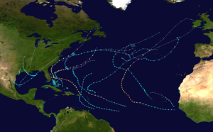
Hurricane Humberto (2019)
Hurricane Humberto was a large and powerful tropical cyclone that caused extensive wind damage in the British Overseas Territory of Bermuda during September 2019. It was the eighth named storm, third hurricane, and second major hurricane – Category 3 or higher on the Saffir–Simpson scale – of the 2019 Atlantic hurricane season. Humberto formed on September 13 from the prolonged interaction of a tropical wave and an upper-level trough, then paralleled the eastern coastline of Florida through September 16 before turning sharply northeastward. A generally favorable environment allowed Humberto to become a hurricane that day, and the storm further strengthened to reach peak intensity as a Category 3 hurricane on September 18. After its center passed within 65 miles (100 km) of Bermuda around 00:00 UTC on September 19, the system encountered stronger wind shear and drier air. Stripped of its deep thunderstorm activity, the system transitioned to a potent extratropical cyclone early on September 20.
| Category 3 major hurricane (SSHWS/NWS) | |
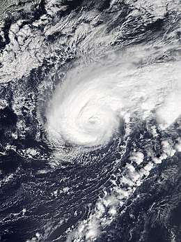 Hurricane Humberto near peak intensity west of Bermuda on September 18 | |
| Formed | September 13, 2019 |
|---|---|
| Dissipated | September 20, 2019 |
| Highest winds | 1-minute sustained: 125 mph (205 km/h) |
| Lowest pressure | 950 mbar (hPa); 28.05 inHg |
| Fatalities | 2 total (United States) |
| Damage | > $25 million (2019 USD) |
| Areas affected | Bahamas, East Coast of the United States, Puerto Rico, Bermuda |
| Part of the 2019 Atlantic hurricane season | |
Forming on the heels of Hurricane Dorian two weeks prior, Humberto proved far less destructive throughout the Bahamas, producing only some squally weather. The eastern coastline of Florida saw tropical storm-force wind gusts, choppy seas, and light rainfall. Rip currents killed one person in Florida and another in North Carolina. In Bermuda, coastal flooding and rainfall were limited by low astronomical tides and Humberto's quick forward motion. However, peak surface winds of around 110 mph (177 km/h), with higher gusts, caused widespread damage to trees, roofs, crops, and power lines, most notably on the western end of the island chain. Some 90% of Bermuda's banana crop was lost. As many as 600 buildings suffered roof damage, while 27,900 customers were left without power; though most of the network was quickly repaired, some electric outages persisted for at least 10 days. L.F. Wade International Airport and the Bermuda Weather Service campus both suffered property damage. In total, the hurricane wrought over $25 million in damage throughout Bermuda. Hurricane Jerry to the south briefly posed a threat to the territory as cleanup from Humberto got underway, but it ultimately dissipated with no ill-effects.
Meteorological history
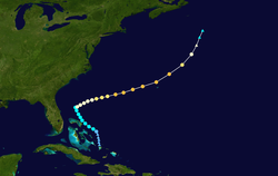
The origins of Humberto trace back to a tropical wave that exited the western coast of Africa on August 27, 2019. Accompanied by little convective activity, the disturbance moved westward across the Atlantic for several days. On September 4, the wave encountered a mid- to upper-level trough of low pressure several hundred miles east of the Lesser Antilles. Resistance from the trough split the wave in two; the southern portion proceeded through the Windward Islands, while the northern portion of the wave moved toward the northwest in tandem with the trough. As the trough became negatively tilted, or oriented northwest-to-southeast, strengthening anticyclonic flow on its east side promoted periods of enhanced convection close to the tropical wave. These convective bursts, largely driven by diurnal cycles, led to the development of a broad surface low on the morning of September 12 as the disturbance turned north-northwest through the Turks and Caicos Islands.[1] At 21:00 UTC, the National Hurricane Center (NHC) upgraded the disturbance to a potential tropical cyclone, given that it posed a threat to land but its circulation did not yet meet the organization necessary to designate a tropical cyclone. This facilitated the issuance of tropical storm warnings in the Bahamas.[2] Observations from ships and nearby islands early on September 13 indicated that the low-level center had become better defined, and satellite imagery depicted the formation of a narrow curved spiral band in the disturbance's northeastern quadrant. Based on this evidence, the NHC estimated that a tropical depression formed around 18:00 UTC on September 13, approximately 85 miles (140 km) east of Eleuthera in the Bahamas. It intensified into Tropical Storm Humberto six hours later.[1]
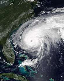
The newly formed cyclone slowly turned northwestward as it tracked toward a weakness in the Azores high.[1] Dry air and wind shear imparted by the trough that contributed to Humberto's genesis now inhibited organization, and the tropical storm more closely resembled a subtropical cyclone rather than a fully tropical one during September 14.[3] As the day progressed, reconnaissance missions found a more aligned storm center, an indication that upper-level winds were beginning to relent. Banding features flourished, upper-level outflow expanded, and a formative inner core became apparent.[4] By 00:00 UTC on September 16, Humberto intensified into the season's third hurricane as it temporarily stalled about 175 miles (280 km) east-northeast of Cape Canaveral, Florida. From that point, a broad upper-level trough over the East Coast of the United States steered the cyclone sharply toward the northeast.[1] While moving over sea surface temperatures of around 84°F (29°C),[5] Humberto intensified during the next day.[1] The hurricane developed a large eye, 35–40 miles (55–65 km) diameter, surrounded by very cold cloud tops, a hallmark of intense thunderstorm activity. Data from a reconnaissance aircraft mission on the evening of September 17 was used as the basis for upgrading Humberto to a Category 3 hurricane around 00:00 UTC on September 18.[1][6] This upgrade was applied despite a broad and asymmetric wind field that was most expansive in the southern semicircle.[7]
As Humberto passed about 65 miles (100 km) northwest of Bermuda around 00:00 UTC on September 19, it reached maximum sustained winds of 125 mph (205 km/h). Some satellite intensity estimates supported Category 4 status, and a dropsonde in the southern eyewall measured winds aloft of 159 mph (256 km/h), in addition to surface winds of 131 mph (211 km/h). However, these values were recorded at two-second intervals and, consequently, were not representative of sustained winds. Additionally, weather radar imagery from Bermuda indicated a quickly eroding eyewall. Therefore, the strongest winds were likely the result of extratropical processes producing a wind maximum akin to a sting jet, which would not be indicative of Humberto's true strength as a tropical cyclone.[1] As Humberto accelerated ahead of the encroaching upper-level trough to its west, it encountered even stronger upper-level winds and drier air that together triggered a weakening trend. By 00:00 UTC on September 20, the system had become devoid of organized deep convection, marking its transition to an extratropical cyclone while located 575 miles (925 km) south-southwest of Cape Race, Newfoundland. The post-tropical cyclone continued to produce a large area of gale-force winds until it merged with an even larger extratropical low around 18:00 UTC on September 20.[1]
Preparations
Immediately upon the designation of a potential tropical cyclone, tropical storm warnings were issued for the northwestern Bahamas, except Andros Island.[8] At 03:00 UTC on September 13, a tropical storm watch was issued for the east coast of the Florida Peninsula between Jupiter Inlet and the Volusia–Brevard County line. After an expansion northward to include more of the Florida coastline, the watch was canceled early the next day.[1]
A tropical storm watch was first issued for Bermuda at 21:00 UTC on September 16 and ultimately upgraded to a hurricane warning 24 hours later. All tropical cyclone watches and warnings were discontinued by 06:00 UTC on September 19, after the storm's departure.[1] Changes in the hurricane's structure as it approached the territory posed some forecasting challenges, especially concerning the arrival time and magnitude of damaging winds.[9] Ahead of the storm, eight cruise ships were diverted away from Bermuda.[10][11] As early as September 16, L.F. Wade International Airport officials requested that vehicles be moved out of the flood-prone long-term parking area.[12] As conditions deteriorated, the airport closed at 19:00 UTC on September 18,[9] resulting in the cancellation of twelve commercial flights.[11] Aircraft were also evacuated from the airport during the closure.[13] "The Causeway", a route connecting the airport to the territory's population centers, was closed as a precautionary measure shortly after a public curfew took effect at 21:00 UTC on September 18.[10][13] Ferry services were suspended at the same time, while buses stopped running in the late afternoon.[14]
The government opened its only official hurricane shelter in the Cedarbridge Academy. It was staffed by 30 people from various agencies and provided accommodation for up to 100 residents. Individuals who lived on boats or who felt unsafe in their homes were encouraged to take advantage of the facility. Ultimately, nearly 50 people sought refuge there.[15][13] In an effort to communicate storm dangers to the public, Bermuda's government held a public press conference, activated the Emergency Measures Organisation's emergency broadcast radio station, and sent updates to users of a new official mobile app called Tree Frog,[9][14] introduced just months prior.[16] Governor John Rankin placed 120 members of the Royal Bermuda Regiment on standby,[15] and ambulances and Bermuda Electric Light Company (BELCO) crews were pre-positioned in strategic locations across the island.[15] Schools, businesses, and governmental offices were closed at 16:00 UTC on September 18.[14][15] The Bermuda Stock Exchange was also closed on September 18 and 19.[17] Many boat owners removed their vessels from marinas to secure them on land.[18]
Impacts
The Bahamas
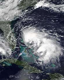
Devastated by Hurricane Dorian earlier in the month,[19] the Bahamas were spared significant compounding effects from Tropical Storm Humberto. Grand Bahama International Airport in the northwestern part of the country reported ten-minute sustained winds of just 29 mph (46 km/h) as the storm passed to the east, and rainfall totals were light.[1] Humberto's proximity to the disaster area caused small airfields being used in the distribution of emergency supplies to be closed briefly.[20]
United States
Rip currents produced by Humberto affected the East Coast of the United States for several days. Conditions were particularly treacherous in northeastern Florida, where strong onshore winds and resulting choppy seas made ocean rescues difficult.[21] In St. Johns County, 21 bathers were rescued from rough seas on September 14 and 15.[1] One rip current victim in the county was found dead after a two-day search, while another was hospitalized in critical condition.[21][22] In Duval County, wind gusts on the periphery of Humberto reached 45 mph (72 km/h).[23] Florida's eastern coastline also experienced a minor 1 to 1.5 ft (0.30 to 0.46 m) storm surge and light rainfall.[1] Farther north, in Topsail Beach, North Carolina, a 62-year-old man drowned after wading into shallow water and getting caught in a rip current.[24]
Later, as the storm grew in strength and size, powerful swells propagated southward to the northern coast of Puerto Rico. In addition to coastal flooding, extensive beach erosion damaged some waterfront structures in Espinar, Agunda.[25]
Bermuda
Powerful westerly winds were the most severe aspect of the hurricane in Bermuda.[1] The highest wind speeds occurred during a relatively brief period between 23:00 UTC on September 18 and 02:00 UTC on September 19, coinciding with the closest approach of Humberto's center.[10] At the height of the storm, rapid fluctuations in air pressure and temperature were observed concurrently with highly turbulent wind patterns.[9] Though unconfirmed, localized tornadic activity in Humberto's right-front quadrant may have been responsible for instances of isolated damage hours before hurricane-force winds spread across the islands.[9] The quick-moving system was accompanied by only 1.57 in (40 mm) of rain,[1] insufficient to wash away foliage-burning salt residue.[26][27] Peak storm surge values were under 3 ft (0.91 m),[1] and low astronomical tides prevented any significant coastal flooding.[28] The lowest air pressure recorded in Bermuda was 970.4 mbar (28.66 inHg), and the highest waves in the seas off the territory's northern coast were analyzed near 42 ft (13 m).[9]
Analysis of observations from a buoy located 9 mi (14 km) off the northwestern coast indicated that parts of Bermuda experienced sustained winds near Category 3 intensity. The instrument recorded ten-minute average winds of 94 mph (152 km/h) gusting to 130 mph (209 km/h), at an elevation of 20 ft (6 m). Adjusting for standard elevation and then converting to a one-minute average yields estimated maximum sustained winds of about 110 mph (178 km/h).[1][9] On Pearl Island, one-minute sustained winds reached 100 mph (161 km/h), punctuated by gusts as high as 123 mph (198 km/h). L.F. Wade International Airport recorded ten-minute average sustained winds of 82 mph (131 km/h) and a gust of 116 mph (187 km/h). Elevated stations registered even more powerful winds; at 290 ft (88 m) above sea level, the Maritime Operations Centre on St. George's Island measured gusts to 144 mph (232 km/h).[1] A private anemometer on the roof of the historical Commissioner's House (part of the National Museum of Bermuda) recorded an extreme wind gust of 192 mph (309 km/h), but both the National Hurricane Center and Bermuda Weather Service believe this value to have been artificially inflated by the flow of air over the building.[1][9]
These intense winds caused extensive damage, particularly to trees, roofs, and power lines; the worst effects were concentrated in western areas.[1][9] An estimated 500–600 buildings sustained roof damage,[29][30] among them being the Somerset Police Station and an African Methodist Episcopal Church in Sandys Parish.[9][31] This corresponds with the 600 storm-related insurance claims received by three local firms by September 24.[32] Humberto left more than 27,900 electricity customers, around 80% of the territory, without power.[1][10] Many farmers suffered significant losses of fruit and vegetable crops; in particular, 90% of the banana crop was destroyed, requiring an estimated 18 months to recover. This worsened an ongoing shortage of bananas caused by pest insect infestations in imports of the fruit.[33][34] Live plants, including poinsettias and vegetable seedlings, were killed in conjunction with the destruction of nursery greenhouses.[33]
At the airport, security fences and a jet bridge were badly damaged. In the Royal Naval Dockyard, a shipping container blew into the water and presumably sank. A man attempting to ride out the storm on his yacht was briefly imperiled when the vessel broke free from its moorings and eventually wrecked on an island in the Great Sound.[9] Off the northern shore, the wreck of the paddle steamer Montana, a popular dive site, was heavily damaged.[35] The Bermuda Weather Service campus suffered the loss of a satellite dish, antennas, and the weather balloon launching platform, which was blown off its foundation.[9] The agency also lost communication with its Doppler weather radar system near the height of the storm.[10] No major damage was reported in the capital city of Hamilton, though some city parks were closed to the public due to unsafe conditions.[15] The Bermuda Fire and Rescue Service responded to numerous calls for minor fires and other incidents.[15] In total, Humberto caused more than $25 million in damage to Bermuda.[1] Despite the severity of the storm and breadth of damage, no deaths or serious injuries were attributed to the hurricane in the territory.[10]
Aftermath
In the wake of the hurricane, fallen or low-hanging trees and power lines left some Bermuda roads impassable, so officials advised residents to remain indoors.[36] From the early morning hours on September 19, the Royal Bermuda Regiment assisted government agencies in removing debris from roads.[9] To accommodate the influx of horticultural debris, the Marsh Folly Composting Facility waived its gate fee for disposal of vegetation.[15] The Causeway was reopened to traffic around midday on September 19 following assessments by structural engineers.[13] L.F. Wade International Airport reopened around the same time once repairs to the damaged fencing had been rushed to completion.[9] Government offices, businesses, and most ferry routes resumed normal operations on September 20, while public schools remained closed for an additional day while building evaluations were underway. As BELCO crews repaired the electricity infrastructure, the number of power outages fell to 10,000 by the morning of September 21 and to 1,000 on September 26.[15] The company, which is Bermuda's only electricity supplier, received help from retired employees and mutual aid from another utility company based in the United States.[37] Restoration was temporarily slowed by several utility pole fires caused by salt corrosion.[38] A small number of outages persisted 10 days after the storm.[39] Despite swift cleanup in most locations, a few small streets and parts of the Bermuda Railway Trail remained blocked for several weeks.[9]
Immediately after the hurricane, damaged structures were temporarily protected by tarps.[9] Bermuda's Department of Planning relaxed its requirements for building permits to fix certain types of storm-related damage.[40] As a consequence of an ongoing slate tile shortage caused by the inability of local quarries to meet demand, permanent roof repairs were delayed for many residents.[29] With intensifying Hurricane Jerry to the south also considered a potential threat, preparedness measures resumed almost immediately after Humberto's passage. However, Jerry degenerated into a remnant low pressure system before reaching Bermuda, resulting in only a brief period of inclement weather.[9][41] Premier of the British Virgin Islands Andrew Fahie expressed that his government was prepared to help Bermuda cope with the effects of hurricanes Humberto and Jerry.[15]
See also
- Hurricane Fabian (2003), the most recent tropical cyclone to cause fatalities in Bermuda[42]
- Hurricane Gonzalo (2014), the most recent tropical cyclone to make landfall in Bermuda[42]
- List of Bermuda hurricanes
- List of Florida hurricanes (2000–present)
- List of North Carolina hurricanes (2000–present)
- Tornadoes in Bermuda
- Tropical cyclones in 2019
References
- Stacy R. Stewart (February 19, 2020). Tropical Cyclone Report: Hurricane Humberto (PDF) (Report). National Hurricane Center. Retrieved February 25, 2020.
- Lixion A. Avila (March 3, 2020). "Potential Tropical Cyclone Nine Discussion Number 1". National Hurricane Center. Retrieved March 3, 2020.
- John L. Beven II (September 14, 2019). "Tropical Storm Humberto Discussion Number 7". National Hurricane Center. Retrieved September 19, 2019.
- Stacy R. Stewart (September 15, 2019). "Tropical Storm Humberto Discussion Number 12". National Hurricane Center. Retrieved September 19, 2019.
- Stacy R. Stewart (September 16, 2019). "Hurricane Humberto Discussion Number 16". National Hurricane Center. Retrieved April 9, 2020.
- Richard J. Pasch (September 17, 2019). "Hurricane Humberto Discussion Number 22". National Hurricane Center. Retrieved September 19, 2019.
- Stacy R. Stewart (September 17, 2019). "Hurricane Humberto Discussion Number 20". National Hurricane Center. Retrieved September 19, 2019.
- Lixion A. Avila (September 12, 2019). "Potential Tropical Cyclone Nine Advisory Number 1". National Hurricane Center. Retrieved October 3, 2019.
- James Dodgson (February 21, 2020). "Country Report from Bermuda for the 42nd Session of the WMO Regional Association IV Hurricane Committee" (PDF). Bermuda Weather Service. Retrieved February 28, 2020.
- Mark Guishard; James Dodgson; Michael Johnston (February 2020). "Hurricanes – General Information for Bermuda". Bermuda Weather Service. Retrieved February 27, 2020.
- "13 Flights, 8 Cruises Cancelled Due To Storms". Bernews. October 11, 2019. Retrieved February 29, 2020.
- "Car owners asked to move vehicles at airport". The Royal Gazette. September 16, 2019. Retrieved February 27, 2020.
- "Humberto: the aftermath". The Royal Gazette. September 19, 2019. Retrieved February 27, 2020.
- "Weather Alert: Hamilton (Bermuda), Updated Weather Alert". Overseas Security Advisory Council. September 17, 2019. Retrieved February 27, 2020.
- "Live Updates: 'Tropical Storm Warning' Issued". Bernews. September 2019. Retrieved February 27, 2019.
- "Govt & Bermuda College Launch 'Tree Frog' App". Bernews. April 25, 2019. Retrieved February 28, 2020.
- "BSX To Close Due To Hurricane Humberto". Bernews. September 18, 2019. Retrieved February 27, 2020.
- Sarah Lagan (September 16, 2019). "Dockyard boats come ashore ahead of storm". The Royal Gazette. Retrieved February 27, 2020.
- "Search for survivors of Hurricane Dorian continues in Bahamas". The Guardian. September 9, 2019. Retrieved February 28, 2020.
- "Cleanup Resumes In Bahamas As Humberto Swirls Away". The Tribune. Associated Press. September 15, 2019. Retrieved February 28, 2020.
- "Storm Events Database: Rip Current". National Oceanic and Atmospheric Administration. National Centers for Environmental Information. Retrieved February 6, 2020.
- Colleen Jones (September 30, 2019). "Should St. Johns County keep lifeguards on longer into summer season?". The St. Augustine Record. Retrieved February 6, 2020.
- "Storm Events Database: Thunderstorm Wind". National Oceanic and Atmospheric Administration. National Centers for Environmental Information. Retrieved February 6, 2020.
- "62-year-old man drowns after getting caught in rip current at Topsail Beach". WTVD-TV. Associated Press. September 19, 2019. Archived from the original on September 21, 2019. Retrieved February 6, 2019.
- "Storm Events Database: Coastal Flood". National Oceanic and Atmospheric Administration. National Centers for Environmental Information. Retrieved February 6, 2020.
- Owain Johnston-Barnes (November 2, 2019). "Humberto has more impact on some birds". The Royal Gazette. Retrieved March 1, 2020.
- Paul Johnston (October 14, 2019). "Humberto's damage still to be cleaned up". The Royal Gazette. Retrieved March 1, 2020.
- Sarah Lagan (October 4, 2019). "Island 'dodged bullet' with Humberto". The Royal Gazette. Retrieved March 1, 2019.
- Paul Johnston (October 7, 2019). "Repairs slowed by slate shortage". The Royal Gazette. Retrieved March 1, 2020.
- "Bermudian Engineers Introduce "Slate 2.0"". Bernews. November 26, 2019. Retrieved March 2, 2020.
- Paul Johnston (September 20, 2019). "Bermuda's west bears brunt of Humberto". The Royal Gazette. Retrieved March 2, 2020.
- Duncan Hall (September 25, 2019). "Insurers deal with hundreds of storm claims". The Royal Gazette. Retrieved March 1, 2020.
- Jonathan Bell (September 21, 2019). "Humberto hits farmers hard". The Royal Gazette. Retrieved March 2, 2020.
- "Minister: Working To Find Ways To Import Bananas". Bernews. February 28, 2020. Retrieved March 2, 2020.
- Sarah Lagan (September 26, 2019). "Shipwreck Montana damaged in storm". The Royal Gazette. Retrieved March 2, 2020.
- Bill Chappel (September 19, 2019). "'We've Made It Through': Bermuda Endures Hurricane Humberto". NPR. Retrieved February 29, 2020.
- Paul Johnston (September 25, 2019). "Belco thanks retirees and volunteers". The Royal Gazette. Retrieved March 1, 2020.
- "BELCO Making Progress, But Facing Setbacks". Bernews. September 24, 2019. Retrieved March 2, 2020.
- "BELCO Saturday Morning Update: 28 Out". Bernews. September 28, 2019. Retrieved March 2, 2020.
- Owain Johnston-Barnes (September 28, 2019). "Repair fees waived after Humberto". The Royal Gazette. Retrieved March 1, 2020.
- "People Urged To Be Ready For Hurricane Jerry". Bernews. September 20, 2019. Retrieved March 1, 2020.
- Mark Guishard; James Dodgson; Michael Johnston (February 2020). "Hurricanes – General Information for Bermuda". Bermuda Weather Service. Retrieved March 28, 2020.
External links
| Wikimedia Commons has media related to Hurricane Humberto (2019). |
- Hurricane Humberto advisory archive from the National Hurricane Center
- "Humberto – Atlantic Ocean" – hurricane and typhoon updates from NASA
- Storm footage on YouTube
- Bermuda Weather Service home page
