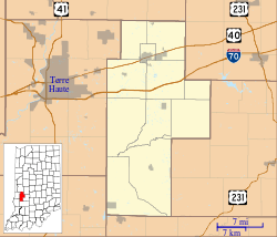
Howesville, Indiana
Howesville is an unincorporated community in Lewis Township, Clay County, Indiana. It is part of the Terre Haute Metropolitan Statistical Area.
Howesville | |
|---|---|
 Howesville Location in Clay County | |
| Coordinates: 39°10′37″N 87°08′49″W | |
| Country | United States |
| State | Indiana |
| County | Clay |
| Township | Lewis |
| Elevation | 548 ft (167 m) |
| ZIP code | 47438 |
| FIPS code | 18-35014[1] |
| GNIS feature ID | 436555[2] |
History
Howesville was laid out in 1856.[3] A post office was established in Howesville in 1858, and remained in operation until it was discontinued in 1909.[4]
Geography
Howesville is located at 39°10′37″N 87°08′49″W.
gollark: I don't. I suppose we should try and explicitly consider exactly what the GEORGE goals are.
gollark: I am just novoting for now.
gollark: (in any case, it's probably less than the resource waste from Electron etc. by rather a lot)
gollark: I do vaguely feel this way about encryption and whatever - if people were trustworthy and nice™, we could save some amount of system resources and key distribution hassle and whatever. As it turns out, though, they aren't, so it isn't very relevant, and even if everyone suddenly did stop being antagonistic, this is a ridiculously unstable state.
gollark: What of the GTech™ contrasocietous chambers™?
References
- "U.S. Census website". United States Census Bureau. Retrieved 2008-01-31.
- "Howesville, Indiana". Geographic Names Information System. United States Geological Survey. Retrieved 2009-10-17.
- Blanchard, Charles (1884). Counties of Clay and Owen, Indiana: Historical and Biographical. F.A. Battey & Company. pp. 332.
- "Clay County". Jim Forte Postal History. Retrieved 30 August 2014.
This article is issued from Wikipedia. The text is licensed under Creative Commons - Attribution - Sharealike. Additional terms may apply for the media files.