Cardonia, Indiana
Cardonia is an unincorporated community in Van Buren Township, Clay County, Indiana. It is part of the Terre Haute Metropolitan Statistical Area.
Cardonia | |
|---|---|
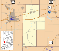 Cardonia Location in Clay County | |
| Coordinates: 39°33′42″N 87°06′28″W | |
| Country | United States |
| State | Indiana |
| County | Clay |
| Township | Van Buren |
| Elevation | 682 ft (208 m) |
| ZIP code | 47834 |
| FIPS code | 18-10234[1] |
| GNIS feature ID | 432127[2] |
History
Cardonia was founded in the year 1871 as a coal mining town.[3] It was named for John F. Card, a mining official.[4] A post office was established in Cardonia in 1879, and remained in operation until it was discontinued in 1909.[5]
Geography
Cardonia is located at 39°33′42″N 87°06′28″W.
gollark: I prefer the second one. My favourite is Fira Code, though.
gollark: It's a weird american word for school year.
gollark: Fine, compare with your weird definition:Both .NETBoth support OOP a bit and FP a bitCan't think of much else.
gollark: to name a few
gollark: * OOPy vs FPy* Verbose vs not verbose* Brackety vs Indentationy/whitespacey
References
- "U.S. Census website". United States Census Bureau. Retrieved 2008-01-31.
- "Cardonia, Indiana". Geographic Names Information System. United States Geological Survey. Retrieved 2009-10-10.
- Blanchard, Charles (1884). Counties of Clay and Owen, Indiana: Historical and Biographical. F.A. Battey & Company. pp. 248.
- Baker, Ronald L. (October 1995). From Needmore to Prosperity: Hoosier Place Names in Folklore and History. Indiana University Press. p. 87. ISBN 978-0-253-32866-3.
...and named for John F. Card, then president of the company.
- "Clay County". Jim Forte Postal History. Archived from the original on 3 September 2014. Retrieved 30 August 2014.
Municipalities and communities of Clay County, Indiana, United States | ||
|---|---|---|
| City | Map of Indiana highlighting Clay County | |
| Towns | ||
| Townships | ||
| CDP | ||
| Other unincorporated communities |
| |
| Ghost towns | ||
| Footnotes | ‡This populated place also has portions in an adjacent county or counties | |
This article is issued from Wikipedia. The text is licensed under Creative Commons - Attribution - Sharealike. Additional terms may apply for the media files.