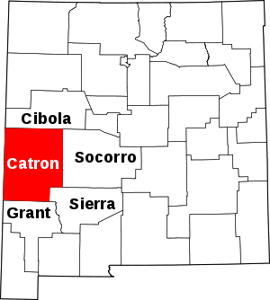
Homestead, New Mexico
Homestead is a census-designated place in Catron County, New Mexico, United States. Its population was 47 as of the 2010 census.[1]
Homestead, New Mexico | |
|---|---|
 Homestead | |
| Coordinates: 34°08′56″N 107°52′55″W | |
| Country | United States |
| State | New Mexico |
| County | Catron |
| Area | |
| • Total | 1.172 sq mi (3.04 km2) |
| • Land | 1.171 sq mi (3.03 km2) |
| • Water | 0.001 sq mi (0.003 km2) |
| Elevation | 7,664 ft (2,336 m) |
| Population | |
| • Total | 47 |
| • Density | 40/sq mi (15/km2) |
| Time zone | UTC-7 (Mountain (MST)) |
| • Summer (DST) | UTC-6 (MDT) |
| Area code(s) | 575 |
| GNIS feature ID | 2584113[2] |
Geography
Homestead is located at 34.145226°N 107.877703°W. According to the U.S. Census Bureau, the community has an area of 1.172 square miles (3.04 km2); 1.171 square miles (3.03 km2) of its area is land, and 0.001 square miles (0.0026 km2) of it is water.[1]
gollark: Oh, right.
gollark: Unless you make the thing produce spores somehow?
gollark: Although you would have to keep feeding the backup glucose. Which is not ideal.
gollark: It could be good for long term backup stuff, though.
gollark: I mean, actual DNA on its own wouldn't be, but splice it into bacteria or something.
References
- "2010 Census Gazetteer Files - Places: New Mexico". U.S. Census Bureau. Archived from the original on July 14, 2014. Retrieved August 22, 2014.
- "Homestead Census Designated Place". Geographic Names Information System. United States Geological Survey.
This article is issued from Wikipedia. The text is licensed under Creative Commons - Attribution - Sharealike. Additional terms may apply for the media files.
