Cruzville, New Mexico
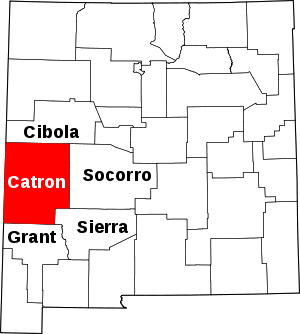
Cruzville is a census-designated place in Catron County, New Mexico, United States, 9 miles (14 km) northeast of Reserve. It is located in the Apache National Forest.[2] As of the 2010 census it had a population of 72.[3]
Cruzville, New Mexico | |
|---|---|
 Cruzville Location within the state of New Mexico | |
| Coordinates: 33°48′26″N 108°39′55″W[1] | |
| Country | United States |
| State | New Mexico |
| County | Catron |
| Area | |
| • Total | 2.5 sq mi (6.6 km2) |
| • Land | 2.5 sq mi (6.6 km2) |
| • Water | 0 sq mi (0 km2) |
| Population (2010) | |
| • Total | 72 |
| • Density | 28/sq mi (10.9/km2) |
| Time zone | UTC-5 (Mountain (MST)) |
| • Summer (DST) | MDT |
| Area code(s) | 575 |
References
- U.S. Geological Survey Geographic Names Information System: Cruzville, New Mexico
- Banks, P.H. (nd) Cruzville, Apache Creek, Aragon and Old Horse Springs — NM Hwy12 from Reserve to Datil Archived June 8, 2007, at the Wayback Machine. SouthernNewMexico.com. Retrieved 6/13/07.
- "Geographic Identifiers: 2010 Demographic Profile Data (G001): Cruzville CDP, New Mexico". U.S. Census Bureau, American Factfinder. Archived from the original on February 12, 2020. Retrieved October 16, 2014.
This article is issued from Wikipedia. The text is licensed under Creative Commons - Attribution - Sharealike. Additional terms may apply for the media files.
