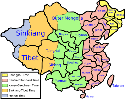
Historical time zones of China
The time zones of China refer to the time zone divisions used in China between 1918 and 1949. The first time zone plan was proposed by the Central Observatory (now Beijing Ancient Observatory) of the Beiyang government in Peking (Beijing) in 1918. The proposal divided the country into five time zones: Kunlun (UTC+05:30), Sinkiang-Tibet (UTC+06:00), Kansu-Szechwan (UTC+07:00), Chungyuan (UTC+08:00) and Changpai (UTC+08:30). These time zones were ratified in 1939 by the Nationalist government in the Standard Time Conference, hosted by the Ministry of Interior of Executive Yuan. Because of the Second Sino-Japanese War, it was also stated that Kansu-Szechwan time shall be the sole national time during the war time. After the war in 1945, these five times zones were implemented national widely. In 1949, after the Chinese Civil War, the Central People's Government abolished the five time zones and announced to use a single time zone UTC+08:00 named Beijing Time (北京时间). The term Chungyuan Standard Time (中原標準時間) was still used by the Nationalist government on Taiwan until the early 2000s.
Overview of the time zones
| Times zones of China from 1918 to 1949 (incl. claimed territories) | |||||
|---|---|---|---|---|---|
 | |||||
| Color | |||||
| Time offset | UTC+05:30 | UTC+06:00 | UTC+07:00 | UTC+08:00 | UTC+08:30 |
| Name | Kunlun | Sinkiang-Tibet | Kansu-Szechwan | Chungyuan | Changpai |
| Chinese | 崑崙時區 | 新藏時區 | 隴蜀時區 | 中原時區 | 長白時區 |
| Pinyin | Kūnlún Shíqū | Xīn-Zàng Shíqū | Lǒng-Shǔ Shíqū | Zhōngyuán Shíqū | Chángbái Shíqū |
| Name origin | Kunlun Mountains | Sinkiang (Xinjiang) and Tibet | Kansu (Gansu) and Szechwan (Sichuan) | The Central Plain | Changpai (Changbai) Mountains |
| Ref. longitude | 82°30′E | 90°E | 105°E | 120°E | 127°30′E |
| Approx. present day tz database |
CN Asia/Kashgar | CN Asia/Urumqi MN Asia/Hovd | CN Asia/Chongqing MN Asia/Ulaanbaatar | CN Asia/Shanghai HK Asia/Hong_Kong MC Asia/Macau MN Asia/Choibalsan TW Asia/Taipei | CN Asia/Harbin |
Time zones and administrative divisions
| Time zone | Historical administrative divisions (as of 1945–49) | Present administrative divisions |
|---|---|---|
| Kunlun 崑崙時區 (UTC+05:30) |
|
|
| Sinkiang-Tibet 新藏時區 (UTC+06:00) |
|
|
| Kansu-Szechwan 隴蜀時區 (UTC+07:00) |
|
|
| Chungyuan 中原時區 (UTC+08:00) |
|
|
| Changpai 長白時區 (UTC+08:30) |
|
|
See also
- Time in China
- Time zones