Hillsborough Parish, New Brunswick
Hillsborough is a civil parish[lower-alpha 1] in Albert County, New Brunswick, Canada. For governance purposes it is divided between the village of Hillsborough and the local service district of the parish of Hillsborough.
Hillsborough | |
|---|---|
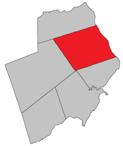 Location within Albert County. | |
| Coordinates: 45.92°N 64.70°W | |
| Country | |
| Province | |
| County | Albert County |
| Established | 1786 |
| Area | |
| • Land | 304.05 km2 (117.39 sq mi) |
| Population (2016)[1] | |
| • Total | 1,308 |
| • Density | 4.3/km2 (11/sq mi) |
| • Pop 2011-2016 | |
| • Dwellings | 649 |
| Time zone | UTC-4 (AST) |
| • Summer (DST) | UTC-3 (ADT) |
Delineation
Hillsborough Parish is defined in the Territorial Division Act[2] as being bounded:
- South and west by the south line of lot numbered seventeen, granted to William Carlisle and its prolongation westerly to the distance of twelve miles from The Petitcodiac River; thence by a line running north twenty degrees west by the magnet of the year one thousand seven hundred and sixty-five to Coverdale Parish; north by Coverdale Parish; and east by the Petitcodiac River.
History
Albert County was established as a Nova Scotian township in 1765, and became part of New Brunswick as the Parish of Hillsborough (Westmorland County) in 1786: named for Wills Hill (1718-1793), Earl of Hillsborough and the lord commissioner of trade and plantations: Hillsborough Parish included Coverdale Parish until 1828
Located on west side of the Petitcodiac River, 2.26 km NW of Surrey: Hillsborough Parish, Albert County: formerly called German Village for Henry Steeves and a group of German settlers who arrived in 1765 from Pennsylvania: renamed with the creation of the post office: PO Hillsborough from 1840: in 1866 Hillsborough was a community with approximately 167 families: Richard E. Steeves was postmaster and David Wallace was a mill owner: the Albert Mining Company was located nearby: in 1871 Hillsborough had a population of 900: in 1898 Hillsborough was a seaport, a port of entry and a settlement on the Salisbury and Hillsborough Railway with 1 post office, 8 stores, 2 hotels, 1 tannery, 1 carriage factory, nearby gypsum mines and a population of 700: Hillsborough was incorporated as a village in 1966[3]
Communities
Parish population total does not include incorporated municipalities (in bold).
|
|
|
Bodies of water & Islands
This is a list of rivers, lakes, streams, creeks, marshes and Islands that are at least partially in this parish
- Petitcodiac River
- Grays Island
- Stoney Creek
Demographics
Access Routes
Highways and numbered routes that run through the parish, including external routes that start or finish at the parish limits:[6]
See also
Notes
- Civil parishes served a variety of government functions until 1966, when the new Municipalities Act stripped them of their responsibilities; parishes continue to provide convenient boundaries for federal and provincial electoral districts. Statistics Canada uses civil parishes as census subdivisions for all parts of the province that are not within municipalities and similar entities.
References
- "Census Profile, 2016 Census: Hillsborough, Parish [Census subdivision], New Brunswick". Statistics Canada. Retrieved September 4, 2019.
- "Territorial Division Act (R.S.N.B. 1973, c. T-3)". Government of New Brunswick website. Retrieved 23 August 2016.
- New Brunswick Provincial Archives, Government of New Brunswick.
- Statistics Canada: 2001, 2006 census
- 2011 Statistics Canada Census Profile: Hillsborough Parish, New Brunswick
- Atlantic Canada Back Road Atlas ISBN 978-1-55368-618-7
Places adjacent to Hillsborough Parish, New Brunswick | |
|---|---|
| Subdivisions |
|
|---|---|
| Cities | |
| Counties | |
| |