Hopewell Parish, New Brunswick
Hopewell is a civil parish[lower-alpha 1] in Albert County, New Brunswick, Canada. Currently, Hopewell parish houses two local government organizational units; the municipality of Riverside-Albert, NB of Riverside-Albert and the local service district of the parish of Hopewell.
Hopewell | |
|---|---|
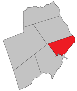 Location within Albert County. | |
| Coordinates: 45.81°N 64.66°W | |
| Country | |
| Province | |
| County | Albert |
| Established | 1786 |
| Area | |
| • Land | 149.08 km2 (57.56 sq mi) |
| Population (2016)[1] | |
| • Total | 647 |
| • Density | 4.3/km2 (11/sq mi) |
| • Pop 2011-2016 | |
| • Dwellings | 319 |
| Time zone | UTC-4 (AST) |
| • Summer (DST) | UTC-3 (ADT) |
Delineation
Hopewell Parish is defined in the Territorial Division Act[2] as being bounded:
- North by Hillsborough Parish; southeast by Chignecto Bay; and southwest by a line commencing at the mouth of Shepody River; thence up the centre of the said river to the mouth of Crooked Creek; thence up the centre of the said creek to the old bridge over the same on the old main road;[lower-alpha 2] and thence north twenty degrees west to intersect the south line of Hillsborough Parish or its westerly prolongation.
History
The origins of the name and place date back to a settlement scheme by colony of Nova Scotia private investors who received the township grant in 1765. The later formation of the Province of New Brunswick in 1786 saw the adoption of the township grant's boundaries for the civil parish. When the original counties were drawn, Saint John County abutted the Hopewell grant line along the coast at Hebron. In later adjustments, the northern boundary was altered in the creation of Albert County and the parish of Harvey. The eastern boundary became the western extent of Harvey Parish and the eastern extent of Alma parish in what had been St. Martins parish, Saint John County. possibly named for Hopewell, Pennsylvania, home of some of the settlers to the township: may have also been named for the ship (Hopewell) that brought a group of settlers from Ireland in 1761: Harvey Parish was set off from Harvey in 1838.[3]
Communities
Parish population total does not include incorporated municipalities (in bold).
|
|
|
Bodies of water & Islands
This is a list of rivers, lakes, streams, creeks, marshes and Islands that are at least partially in this parish
- Petitcodiac River
- Demoiselle Creek
Demographics
Access Routes
Highways and numbered routes that run through the parish, including external routes that start or finish at the parish limits:[6]
|
|
|
|
See also
Footnotes
- Civil parishes served a variety of government functions until 1966, when the new Municipalities Act stripped them of their responsibilities; parishes continue to provide convenient boundaries for federal and provincial electoral districts. Statistics Canada uses civil parishes as census subdivisions for all parts of the province that are not within municipalities and similar entities.
- Neither road nor bridge appear on provincial highway maps.
References
- "Census Profile, 2016 Census: Hopewell, Parish [Census subdivision], New Brunswick". Statistics Canada. Retrieved September 4, 2019.
- "Territorial Division Act (R.S.N.B. 1973, c. T-3)". Government of New Brunswick website. Retrieved 23 August 2016.
- New Brunswick Provincial Archives, Government of New Brunswick.
- Statistics Canada: 2001, 2006 census
- 2011 Statistics Canada Census Profile: Hopewell Parish, New Brunswick
- Atlantic Canada Back Road Atlas ISBN 978-1-55368-618-7
Places adjacent to Hopewell Parish, New Brunswick | |
|---|---|
| Subdivisions |
|
|---|---|
| Cities | |
| Counties | |
| |