Elgin Parish, New Brunswick
Elgin is a civil parish[lower-alpha 1] in Albert County, New Brunswick, Canada. For governance purposes it is divided between the local service districts of Elgin and the parish of Elgin; their corresponding Taxing Authorities are called Elgin Centre and Elgin Parish.[2]
Elgin | |
|---|---|
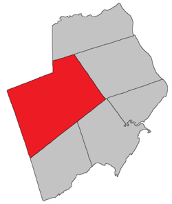 Location within Albert County. | |
| Coordinates: 45.89°N 64.83°W | |
| Country | |
| Province | |
| County | Albert |
| Established | 1847 |
| Area | |
| • Land | 519.59 km2 (200.61 sq mi) |
| Population (2016)[1] | |
| • Total | 892 |
| • Density | 1.7/km2 (4/sq mi) |
| • Pop 2011-2016/small> | |
| • Dwellings | 595 |
| Time zone | UTC-4 (AST) |
| • Summer (DST) | UTC-3 (ADT) |
Delineation
Elgin Parish is defined in the Territorial Division Act[3] as being bounded:
- North by Coverdale Parish and the County line; east by Hillsborough Parish; south by Harvey Parish and Alma Parish, and west by the County line.
History
Albert County: established in 1847 from part of Salisbury Parish, Westmorland County and named for James Bruce, 8th Earl of Elgin (1811-1862), who was the Governor General of British North America from 1847-1854.
Located 4.3 km ENE of Goshen: Elgin Parish, Albert County: PO from 1852: in 1866 Elgin was a farming settlement with about 36 families: in 1871 Elgin had a population of 250: in 1898 Elgin was a station on the Elgin, Petitcodiac and Havelock Railway with 1 post office, 6 stores, 3 hotels, 1 sawmill, 1 grist mill, 1 tannery, 1 carriage shop, 1 cheese factory and 2 churches.[4]
Communities
Parish population total does not include incorporated municipalities (in bold).
|
|
|
Demographics
Population
LanguageMother tongue language (2016)[1]
| |||||||||||||||||||||||||||||||||||||||
Access routes
Highways and numbered routes that run through the parish, including external routes that start or finish at the parish limits:[7]
See also
Notes
- Civil parishes served a variety of government functions until 1966, when the new Municipalities Act stripped them of their responsibilities; parishes continue to provide convenient boundaries for federal and provincial electoral districts. Statistics Canada uses civil parishes as census subdivisions for all parts of the province that are not within municipalities and similar entities.
References
- "Census Profile, 2016 Census: Elgin, Parish [Census subdivision], New Brunswick". Statistics Canada. Retrieved August 26, 2019.
- "2019 Local Government Statistics for New Brunswick" (PDF). Department of Environment and Local Government. p. 59. Retrieved 8 July 2020.
- "Territorial Division Act (R.S.N.B. 1973, c. T-3)". Government of New Brunswick website. Retrieved 19 August 2016.
- New Brunswick Provincial Archives, Government of New Brunswick.
- Statistics Canada: 2001, 2006 census
- 2011 Statistics Canada Census Profile: Elgin Parish, New Brunswick
- Atlantic Canada Back Road Atlas ISBN 978-1-55368-618-7
Places adjacent to Elgin Parish, New Brunswick | |
|---|---|
| Subdivisions |
|
|---|---|
| Cities | |
| Counties | |
| |