Highway M15 (Ukraine)
Highway M15 is a Ukrainian international highway (M-highway) connecting Odessa to Reni. The entire route is part of European route E87.[1] The highway is also known as the highway Odesa–Reni.
| |
|---|---|
| Автошлях M15 | |
.png) | |
| Route information | |
| Part of | |
| Length | 295.2 km (183.4 mi) |
| Major junctions | |
| East end | |
| West end | Moldovan border in Reni |
| Location | |
| Regions | Odessa Oblast |
| Highway system | |
| Roads in Ukraine | |
Description
The highway crosses the border with Moldova twice and west of the city of Reni it continues as Moldovan national road M3.[2] The highway also passes Moldovan village of Palanca, Ștefan Vodă where Ukraine keeps jurisdiction over the road.
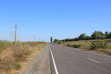
The highway stretches through the historic and cultural region of Budzhak and ends at the "Reni" border checkpoint. As of 2016 it is in extremely poor condition, ranked as one of Ukraine's worst major roads.[3]
The section of M15 from Reni to Izmail was previously designated as P33. Portion of the highway Odesa–Reni between Reni and Orlivka follows narrow strip that is squeezed between Lake Cahul and the Danube.
Route
| Marker | Main settlements | Connections/interchanges |
|---|---|---|
| Odessa municipality | ||
| 0 km | Odessa • Airport "Zastava" | E58 ( M14 - M16 ) • E95 ( M05 - Ferry) • M27 • Tyraspolske shose |
| Bilyayivka Raion / Odessa municipality | ||
| Khlibodarske | ||
| Velykyi Dalnyk | ||
| Rozselenets | ||
| T1620 | ||
| Myrne · Odesa Nuclear Power Plant | Baraboi River | |
| Mayaky | T1625 · Dniester | |
| Bilhorod-Dnistrovskyi Raion / Bilyayivka Raion | ||
| Lower Dniester National Park | ||
| Moldova–Ukraine border | ||
| Palanca checkpoint · Palanca · Nistrul de Jos Ramsar Zone | Moldova–Ukraine border · R31 (Moldova) | |
| Bilhorod-Dnistrovskyi Raion | ||
| Mayaky-Udobne checkpoint | Moldova–Ukraine border · Dniester Estuary | |
| P72 | ||
| Monashi | H33 · Alkalia River | |
| Sarata Raion / Bilhorod-Dnistrovskyi Raion | ||
| Mykolaivka-Novorosiyska · Airport Mykolaivka-Novorosiyska | Khadzhyder River | |
| Sarata · Zorya | T1608 · T1643 | |
| Mykhailivka | ||
| Tatarbunary Raion / Sarata Raion | ||
| Bilolissya | ||
| Tatarbunary | T1610 · T1627 · Kohylnyk River · Sasyk Lagoon | |
| Bashtanivka | ||
| Spaske | T1628 | |
| Kiliya Raion / Tatarbunary Raion | ||
| T1645 · Kyrhizh-Kytai | ||
| Izmail Raion / Kiliya Raion | ||
| Kyrnychky | T1606 | |
| Novokamianka · Suvorove | ||
| Kamianka | T1632 | |
| Utkonosivka | Tashbunar River | |
| Safiany | Byrnova River | |
| Izmail · Izmail Port · Izmail International Airport | T1607 · T1631 · Aerodromne shose · Bolhradske shose · Danube | |
| Larzhanka · Nova Nekrasivka | Repyd River · Lake Kuhurluy · Lake Yalpuh | |
| Reni Raion / Izmail Raion | ||
| Novosilske | ||
| Orlivka | T1629 · Orlivka – Isaccea Ferry · Romania–Ukraine border · Lake Kartal · Lake Cahul · Turkoye Lake · Danube | |
| Reni · Kirhan · Dolynske | T1642 · Danube | |
| 295 km | Reni checkpoint · Giurgiulești · Port of Giurgiulești · Galați checkpoint | Moldova–Ukraine border · E584 / |
References
- European Highways in Russian
- Ukraine International Highways in Russian
- Dan Peleschuk (16 June 2016). "Ukraine's Broken Road to Europe". Foreign Policy. Retrieved 17 June 2016.
External links
- International Roads in Ukraine in Russian
- European Roads in Russian
| E-roads in Ukraine | ||
|---|---|---|
| International | ||
| National | ||
| Regional |
| |
| ||