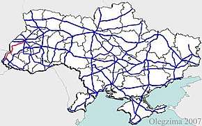
Highway H13 (Ukraine)
H13 is a regional road (P-Highway) in Lviv Oblast and Zakarpattia Oblast, Ukraine. It runs north-south and connects Uzhhorod with Lviv.[1]
| ||||
|---|---|---|---|---|
| Автошлях H13 | ||||
 | ||||
| Route information | ||||
| Length | 232.5 km (144.5 mi) | |||
| Major junctions | ||||
| south end | ||||
| north end | ||||
| Location | ||||
| Regions | Lviv Oblast, Zakarpattia Oblast | |||
| Highway system | ||||
Roads in Ukraine
| ||||
Main route
Main route and connections to/intersections with other highways in Ukraine.[2]
| Marker | Main settlements | Notes | Highway Interchanges |
|---|---|---|---|
| Zakarpattia Oblast | |||
| 0 km | Domanytsi | starts at highway interchange near Uzhhorod | |
| Nevytske | Nevytsky Castle, Uzhhorod Military Training Center | ||
| Perechyn | T0712 | ||
| Malyi Bereznyi | bridge over Ublia | P53 | |
| Zabrid | bridge over Ulichka, Uzhansky National Park | ||
| Zhornava | bridge over Uzh | ||
| Stavne | bridge over Liskivsky brook | ||
| Lubnia | bridge over Uzh, bridge over Lubnia river | ||
| Uzhok | Uzhansky National Park/Nadsiansky Landscape Park | ||
| Sianky | Uzhok pass, near Poland-Ukraine border | ||
| Lviv Oblast | |||
| Hranytsia, Yavoriv | Nadsiansky Landscape Park | ||
| Verkhnie | Western Rehabilitation Sports Center | ||
| Borynia | T1423 | ||
| Turka | T141902 | ||
| Staryi Sambir | T1401 | ||
| Sambir | T1415 • T1418 | ||
| Novyi Kalyniv | Kalyniv Avia base | ||
| Zaluzhany | Jagiellon Airport | T1425 | |
| 154.4 km | Lapayivka | near Lviv | |
gollark: Yeߧ, indeed.
gollark: That's not "logical". That's just a simple thing people like basing things on. It's not not arbitrary.
gollark: I agree.
gollark: But you're making an arbitrary judgement to value stuff which some "logical" rule supports.
gollark: Yes, I am aware of Kant's categorical imperative and probably other things.
See also
References
External links
- Regional Roads in Ukraine in Russian
This article is issued from Wikipedia. The text is licensed under Creative Commons - Attribution - Sharealike. Additional terms may apply for the media files.
