Hampton Court railway station
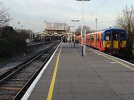
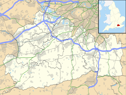
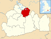
Hampton Court railway station is a suburban terminus station at East Molesey, in the Borough of Elmbridge in the county of Surrey, 100 yards short of Hampton Court Bridge, the midpoint of which is a boundary of Greater London. The station is 14 miles 76 chains (24.1 km) down the line from London Waterloo.[2]
| Hampton Court | |
|---|---|
 | |
 Hampton Court Location of Hampton Court in Surrey | |
| Location | East Molesey |
| Local authority | Elmbridge |
| Managed by | South Western Railway |
| Station code | HMC |
| DfT category | C2 |
| Number of platforms | 2 |
| Accessible | Yes |
| Fare zone | 6 |
| National Rail annual entry and exit | |
| 2014–15 | |
| 2015–16 | |
| 2016–17 | |
| 2017–18 | |
| 2018–19 | |
| Key dates | |
| 1 February 1849 | Opened |
| Other information | |
| External links | |
| WGS84 | 51.4028°N 0.3425°W |
Across the River Thames the station serves Hampton Court Palace and its adjoining park-side houses, riverside homes, hotels and boutiques in the London Borough of Richmond upon Thames, and is in Transport for London's Travelcard Zone 6; the station is across the River Thames from Hampton Court Park, Gardens and Bushy Park.
History
The oldest artifact discovered in the area was a Stone Age era dugout canoe found in the River Mole/River Ember, which is now on display in the museum at Henley-on-Thames. The ground where the station and Park is sited was previously owned by the Church, then Hampton Court Palace, and then gifted to the local council between 1670 and 1840. The station is the terminus of the 1.5-mile (2.4 km) Hampton Court branch line that has one junction — with the South Western main line (west of Surbiton). One through station is on the branch, Thames Ditton. The station was built on the island formed between the river River Mole and its close distributary, the River Ember. Access was first via a wooden bridge from Creek Road. The branch was opened on 1 February 1849.[3] In its first two years the carriages were pulled by horses.[3] Regular steam locomotives replaced the horses in the year 1849-1950 tender-first when proceeding down the line (rather than "up" to London), while construction of the first turntable was underway.[3] By 1868 four lines, four platforms, a railway turntable, a coal depot and ancillary buildings comprised a greater version of the site. The peak capacity of this station was between 1912 and 1929 when over 10 tracks fanned out at the site; four sets of tracks were designated for shuffle sidings (to augment services to the rest of the network); four were dedicated for the station itself and two lines were goods sidings for goods including bulk materials and the coal depot. During this period a Thames-side turntable was removed (the foundations of which were revealed on proposed redevelopment by in 2013). It is believed the turntable was re-established adjacent to Summer Road and Hampton Court Way.
In the 1930s the bed of the mouth of the Mole was filled in and the stream combined with the River Ember to construct Hampton Court Way and the Edward Lutyens-designed, re-aligned Hampton Court Bridge. The station site is owned by Network Rail, and the services operated by South Western Railway using the Class 455 fleet.
Since the 1960s the area adjacent to the river end of the site has been associated with a river ferry landing stage, and an open area with views to the Palace and up and down the River Thames from a "tea and dance room" known as the "Jolly Boatman" (under which the station's Victorian era train turntable was found during archeological excavation in 2013). This closed in the early 1990s and has since been left derelict by the various owners.
Services
The typical off-peak service at the station is two trains per hour to and from London Waterloo via Surbiton and Wimbledon, taking 35 minutes for the 13 miles (21 km) journey.
| Preceding station | Following station | |||
|---|---|---|---|---|
| Thames Ditton | South Western Railway Hampton Court Branch |
Terminus | ||
Station buildings and infrastructure
Trains use both platforms. Ticket machines are present. The ground floor of the station buildings remains in use. The Jacobean style building was designed by Sir William Tite to have ornately decorated windows and doors, and the building is listed. The upper floors are no longer used as station or commercial offices and have been left derelict. Painting of the building for the Olympic Cycle event included overpainting the upper floor windows and sundry repairs.
Disabled access involves platform ramps for kerbs from the pedestrian access from the car park to the pavements and steps from the car park. Passenger waiting areas are external and unheated but under rain proof canopies.
Network Rail have ongoing plans to refurbish the station excluding the upper floors. Recent works include the extension of the platforms to accommodate 10-car trains and refurbishment of the glazing on the late Victorian canopies. There are washroom and toilet facilities at the station. On-platform services include a newsagent, coffee and flower kiosks, capacity for 130 bicycles and an on site car park for commuters and visitors to the area (approximately 200 places). A taxi booking office on-site is no longer in use.
Externally there are the 411, 461 and R68 bus services, a drop off zone, coach parking and a pay and display car park. Access to the river is available at the footings of Hampton Court Bridge adjacent. Depending on weather and tourist events Parrs Boats operate a ferry service from just north of the station. National Cycle Route 4 passes the station.
The station site bounds the historic "sterte" (peninsular) of Cigarette Island and access to this park can be either from the Car Park or via the riverside entrance
In the early 2010s at least one modern ticket machine was installed at all South West Trains' stations at which cash and debit/credit cards can be used to purchase tickets cards to any National Rail destination. The machine here can also top up Oyster cards. In May 2019 Network Rail have installed a new gate-line barrier with multiple ticket readers.
The platform signs date from 2009 and mirror the understated Southeastern example with white lettering on a navy blue field.
Due to its short length, the branch has speed restrictions of 40 miles per hour (64 km/h) on the up line and 45 miles per hour (72 km/h) on the down.
Contested redevelopment projects
Despite failing economic viability tests, planning permission for the extensive redevelopment of the site was granted in 2009, which drew substantial opposition from local residents, from which materialised a campaign group called 'The Hampton Court Rescue Campaign'.[4] This planning permission expired in June 2013. This development proposed a 300 space underground car park with residential and commercial properties above (on the site of the existing car showroom and coach park), a 66 bedroom hotel (on the site of, and to the height of, the existing lighting tower), a care home (on the current Network Rail works compound area at the end of the car park) and townhouses (on the existing car park). To date no works have been carried out by the owner/developer except for the installation of the hoardings and the removal of the historic railway turntable from beneath the "Jolly Boatman" site. A new developer/owners submitted a planning application to redevelop the site. This proposes an increase in density of the buildings and a reduction in the car parking facilities with the use of the public park for temporary car parking. This new proposal includes a 240 space underground car park to be shared with commuters and visitors to the area, as well as the new residential (99 units) on the existing car park and towards the river with commercial properties below to a height greater than the palace opposite, an 88 bedroom hotel (on the site of the existing coach park and car showroom) and townhouses (on the existing car park); this proposal has also drawn opposition from The Hampton Court Rescue Campaign Group.[4]
Network Rail have yet to describe any upgrades to the existing station building as a result of the new £57 million project, and there remain substantial queries about the new car parking/traffic/pedestrian /cycling arrangements, as well as scale and massing of the buildings themselves. As part of the proposed Crossrail 2 infrastructure, Hampton Court has been proposed by business group London First as the terminus for a potential service to Cheshunt via Central London, opening in the "early 2030s".[5]
References
- "Station usage estimates". Rail statistics. Office of Rail Regulation. Please note: Some methodology may vary year on year.
- Yonge, John (November 2008) [1994]. Jacobs, Gerald (ed.). Railway Track Diagrams 5: Southern & TfL (3rd ed.). Bradford on Avon: Trackmaps. map 21B. ISBN 978-0-9549866-4-3.CS1 maint: ref=harv (link)
- http://www.moleseyhistorysociety.org/Horsepower%20on%20the%20Hampton%20Court%20line.pdf
- Hampton Court Rescue Campaign website (2019). http://www.hamptoncourtrescuecampaign.com/
- "Business unveils Crossrail 2 plan". 5 February 2013 – via www.bbc.co.uk.
External links
| Wikimedia Commons has media related to Hampton Court railway station. |
- Train times and station information for Hampton Court railway station from National Rail
