Hallett Cove Conservation Park
Hallett Cove Conservation Park is a protected area in the Australian state of South Australia located in the suburb of Hallett Cove on the coast of Gulf St Vincent about 22 kilometres (14 miles) south of the centre of the state capital of Adelaide.
| Hallett Cove Conservation Park South Australia | |
|---|---|
IUCN category III (natural monument or feature)[1] | |
 Hallett Cove Conservation Park | |
| Nearest town or city | Adelaide |
| Coordinates | 35°04′25″S 138°29′57″E |
| Established | 1 July 1976[2] |
| Area | 51 ha (126 acres)[3] |
| Managing authorities | Department for Environment and Water |
| Website | Hallett Cove Conservation Park |
| See also | Protected areas of South Australia |
Hallett Cove is one of the best known geological sites in Australia and is known for its international significance. The area has been declared a Geological Monument by the Geological Society of Australia and placed on the South Australian Heritage Register for its educational and scientific significance.
History
Hallett Cove is named for John Hallett who discovered the area while searching for lost stock in 1837. In the 1840s the cove was used by smugglers to land goods at night which were then taken to Adelaide by dray. In 1847, the Worthing Mining Company purchased 800 acres (320 ha) from the Hallett family and built a copper mine on the northern side of Hallett's creek. However, the ground proved to be too hard and water kept flooding the diggings. In 1852 the miners left for the Victorian gold rush and the mine was finally abandoned in 1857. Farming began in what is now the eastern section of the park in the 1850s. In the late 1880s the cove was used for naval exercises and the southern area of beach was cleared of rocks to allow landings.[4]
Professor Ralph Tate realised that South Australia had been subjected to an ice age when in 1877 he discovered the area's smoothed and striated glacial pavement. In 1893, "the largest scientific excursion ever held in the Southern Hemisphere" explored the area with Prof. Walter Howchin later demonstrating that the deposits were of Permian age and that Australia was closer to the south pole than today while part of the Gondwanan supercontinent. During that time the south-western two-thirds of Australia, including much of South Australia was covered by an ice sheet. The first detailed description of the geology of the area was published in 1943.[4]
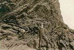
In 1957 Professor A.R. Alderman from the University of Adelaide wrote to the National Trust of South Australia recommending that the glacial pavements along the coastal cliff tops of Hallett Cove be preserved. In 1960, local farmer George Sandison died and the beneficiaries of his estate donated 3.25 acres (1.32 ha) of land, a narrow strip along the cliff tops, to the National Trust of South Australia which was followed not long after by another 8.75 acres (3.54 ha) for an access road. In 1965 the donated land was proclaimed The Sandison Reserve.[4]
In 1965 subdivision of the adjacent land for housing was announced. For the next 11 years conservationists fought against developments. In late 1969, the State Planning Authority declared 51 acres (21 ha) of Hallett Cove a site of scientific interest which prohibited landowners from developing the land in any way that would destroy its scientific value. In 1970 it was announced that the surrounding land would be subdivided and a large private marina built in the cove. The government received tens of thousands of letters of protest and significant public debate ensued. Premier Dunstan guaranteed to protect the area and the government later acquired the cove and a further 67 acres (27 ha) of land.[4] In 1976, the park was declared a Conservation Park dedicated for the protection of features of geological and historic interest.
Aboriginal occupation
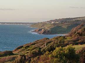
From the right: Hallett Cove beach, Black Cliff, Sandison Park. Waterfall Creek runs to the beach through a gully alongside the housing. Aboriginal campsites were located along the creek to the railway line (the scrub to the right of the housing).
Evidence of local Aboriginal occupation dates back to the end of the most recent ice age, perhaps 12,000 years ago, with one camp site covering several acres which is the largest and possibly the oldest in the Adelaide area. More recently, the Kaurna Aborigines lived on two camp sites dating back 2,000 years and their middens contain shellfish remains and the otoliths (earstones) of Mulloway. Smaller camps have been found on the cliff edge which are believed to have been used by watchers waiting for migrating shoals of Mulloway.
Stone implements were first discovered in Hallett Cove in 1934 with more than 1,700 artefacts being collected over a period of 30 years. The majority are heavily weathered Kartan stone tools weighing up to 5.5 kilograms (12 lb) with over 400 found around the large camp, indicating late Pleistocene occupation with various smaller tools gradually replacing them over time.
Although Kartan tools are traditionally made of Quartzite, often sourced from great distances, all of the finds at Hallett Cove were made of Siltstone despite large amounts of suitable Quartzite being available on the beach. During the late Pleistocene, the sea level was around 90 metres (300 ft) lower than today. From 85,000 to around 15,000 years ago, the present Gulf St Vincent was a deep river valley to the west while the nearest site of exposed Quartzite was likely near the coast, which during that time lay some 350 kilometres (220 mi) to the south. It has been suggested that a debri slope may have stretched far into the gulf, covering the local Quartzite which had likely eroded out only after the present coastline was established around 6,000 years ago. The finds include a number of very well made Quartzite tools of the type in use when Adelaide was settled.[4]
Geology of the park
Late Precambrian
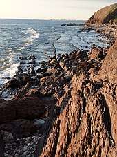
Ripple marks in the oldest Hallett Cove rocks indicate that the sediments that formed them originated on a tidal plain during the upper Precambrian. The plain was part of a shallow sea that bordered an ancient stable landmass[5] to the west while to the east lay ocean as the eastern half of Australia had yet to form. The shallow sea extended around 700 kilometres (430 mi), from the northern-most Flinders Ranges to Kangaroo Island and lay above an unstable depression called the Adelaide Geosyncline which slowly sank as sediments built up, keeping pace so that the water remained shallow from about 870 Ma (the middle Neoproterozoic) to ~500 Ma (the end of the Cambrian). Sediments sinking to the sea floor accumulated, reached a depth of 8 kilometres (5.0 mi) locally to 10 kilometres (6.2 mi) in depth in the Flinders Ranges.[4]
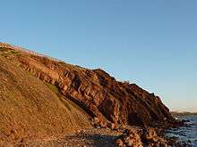
From around 550 Ma the beds of the Geosyncline began a series of intraplate extensional and contractional events. The beds began to buckle, fold, uplift and block fault, creating a range of mountains called the Delamerian Highlands, possibly up to 8 kilometres (5.0 mi) in height.[6] Almost immediately the mountain range began eroding heavily and this process continued for another 200 Ma. The Precambrian rock of Black Cliff and the wave cut platform at Hallett Cove are all that remains of the base of the mountain range in this area and clearly shows complicated folding with several small faults visible. Erosion has removed rock dated less than 570 Ma, but younger overlaying rock (570 - 500Ma) is exposed further south between Sellicks Hill to Normanville. Cambrian fossils have been found in these younger rocks while no fossils have been found in those remaining at Hallett Cove.[4][7]
Today, the remains of the southern section of the Cambrian mountain range are known as the Mount Lofty Ranges which have eroded down to below 730 metres (2,400 ft).
Permian
The 600 Ma Precambrian rocks at Hallet cove are separated from the 270 Ma Permian deposits by an unconformity. If there were periods of deposition between the two periods, erosion has removed all trace.
The formation of Pangaea resulted in extensive glaciation over much of Australia during the Carboniferous and Permian. It is believed that by 270 Ma Australia was part of a supercontinent called Gondwanaland.[7] Crescent shaped cracks in the glaciated pavements at Hallett Cove show that the ice flowed N/NW towards what is now the center of Australia. The ice thus originated in the uplands of land to the south. If current theories of continental drift are correct, this land was Antarctica. The Permian record at Hallett Cove not only records the passage of glaciers but their retreat.
Hallett Cove at this time was part of a river valley orientated with the mountain range to the NE. Ice had scoured a basin and meltwater from the retreating glacier formed a lake which deposited the sediments that can be seen today along the clifftops. Although no fossils have been found in these sediments, arthropod trails have been found in similar sediments further south. Dropstones and erratics, rocks carried by glaciers which drop when they melt, litter the beach where the Permian sediments that once held them have long since been eroded away. Smaller ones can be found still embedded in the sediments. Most of the dropstones, some bigger than cars, originated from sites hundreds of km to the south, however, several consist of rock not found in South Australia and their origin has yet to be determined. One erratic currently eroding out at the top of Black Cliff is dated 400 Million years older than the oldest Hallett Cove rocks. Made of Tillite, it is the earliest evidence of glaciation ever recorded.[4]

Pliocene
.jpg)
A second period of erosion began around 250Ma which removed most of the Permian sediments in the region with the exception of some that were protected by the Hallett cove basin. This forms the second unconformity that separates the Permian from the Pliocene deposits.
By the Cenozoic, the Mt Lofty Ranges had worn down to sea level. A period of faulting commenced which uplifted the ranges and downthrust the plains which, beginning 50Ma was flooded by the sea. By 20Ma the land west of the ranges was a shallow sea. Hallett Cove has no sediments from this period indicating it may have been above sea level, an island in a shallow sea.
Further faulting raised the Mt Lofty Ranges to a little higher than their current elevation and submerged Hallet Cove. Dated at 5Ma to 3Ma, a band of sandstone that had been laid down on a sea floor can be found overlaying the Permian deposits. This layer contains fossil shells and limy sands. Overlaying the sandstone is a considerable thickness of mottled clays with patches of sand and gravel, the sediments washed down from the slopes of the Mt Lofty Ranges from 3Ma to 1Ma when the area was a river flood plain.
Pleistocene
The Pleistocene climate was marked by repeated glacial cycles. During the early pleistocene the rapid accumulation of clays indicates a much wetter climate than today. Following the end of the last glaciation 15,000 years ago, the climate appears to have dried out somewhat as a layer of calcrete overlays the clay deposits. The Gulf St Vincent was an alluvial plain drained by an ancient river when Aboriginals first settled on the Hallett Cove clifftops and their tools have been found in the sand that lies above the calcrete.
Recent
As the glaciers retreated in the Northern Hemisphere, the sea levels rose worldwide. The current sea level stabilised around 6,000 years ago and began to erode the Hallett Cove cliffs. As the folds in the cliff face are almost vertical, the cliff face retreats as the sea breaches the quartzite layers that protect the softer siltstone layers between them forming the zigzag pattern we see today. As the cliff retreats it leaves a wave cut platform behind.
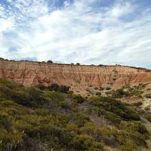
The Amphitheatre is a feature of the park where the Precambrian rocks are below sea level. Without their protection erosion is rapidly cutting through the soft Permian, Pliocene and Pleistocene deposits resulting in a badlands terrain. As the silts are eroded erratics are released which roll down to the base platform and beach.
An interpretative walking trail describes the park's cultural and geological heritage.[8]
See also
- List of protected areas in Adelaide
- Adelaide Rift Complex
References
- "Terrestrial Protected Areas of South Australia (refer 'DETAIL' tab )". CAPAD 2016. Australian Government, Department of the Environment (DoE). 2016. Retrieved 21 February 2018.
- Chatterton, Brian (1 July 1976). "NATIONAL PARKS AND WILDLIFE ACT, 1972-1974: HALLETT COVE CONSERVATION PARK CONSTITUTED" (PDF). The South Australian Government Gazettee. Government of South Australia. p. 7. Retrieved 5 December 2018.
- "Protected Areas Information System - reserve list (as of 25 November 2014)" (PDF). Department of Environment Water and Natural Resources. Retrieved 8 January 2015.
- Cooper, H. M. (Harold Moore), 1886-1970; Kenny, M. (Margaret); Scrymgour, June M; South Australian Museum (1970), Hallett Cove : a field guide / by H.M. Cooper, M. Kenny, J.M. Scrymgour, South Australian MuseumCS1 maint: multiple names: authors list (link)
- Cooyerdoo Rocks, located 375 kilometres (233 mi) NW of Hallett Cove are dated to 3,157 ± 2 Ma
- This mountain range may have been the southern extent of the Petermann Orogeny and part of a suspected Supermountain range that may have stretched more than 8,000 kilometres (5,000 mi) through the newly forming Gondwana supercontinent. The uplifting was so violent that despite now being located in the center of a plate, the Flinders Seismic Zone of which Hallett Cove is part remains one of the most seismically active regions in Australia.
- Australia in time and space Australian National University Pg 84 - 104
- Hallett Cove Conservation Park Parks SA
Further reading
- Major, R. B; Giesecke, R; Whatmough, R; Field Geology Club of South Australia (1999), A field guide to the geology of Hallett Cove and other locations with glacial geology on Fleurieu Peninsula (1st ed.), Field Geology Club of South Australia, ISBN 978-0-9596596-3-4
External links
| Wikimedia Commons has media related to Hallett Cove Conservation Park. |
- Hallett Cove Conservation Park South Australia Department of Environment and Natural Resources. This site includes a pamphlet containing a map of the walking trails. Accessed 22 April 2012.
- "Hallett Cove Conservation Park". City of Marion. Retrieved 2 May 2015.
- Hallett Cove Conservation Park webpage on protected planet