Hale Township, Hardin County, Ohio
Hale Township is one of the fifteen townships of Hardin County, Ohio, United States. As of the 2010 census the population was 1,590,[3] of whom 737 lived in the unincorporated portion of the township.[4]
Hale Township, Hardin County, Ohio | |
|---|---|
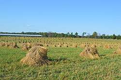 Shocks of wheat on an Amish farm west of Mount Victory | |
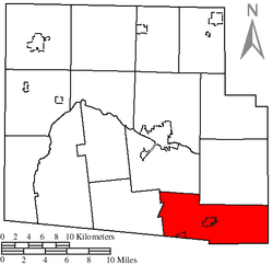 Location of Hale Township, Hardin County, Ohio | |
| Coordinates: 40°31′49″N 83°32′13″W | |
| Country | United States |
| State | Ohio |
| County | Hardin |
| Area | |
| • Total | 36.56 sq mi (94.68 km2) |
| • Land | 36.54 sq mi (94.63 km2) |
| • Water | 0.02 sq mi (0.04 km2) |
| Elevation | 1,050 ft (320 m) |
| Population (2010) | |
| • Total | 1,590 |
| • Density | 44/sq mi (16.8/km2) |
| Time zone | UTC-5 (Eastern (EST)) |
| • Summer (DST) | UTC-4 (EDT) |
| FIPS code | 39-32837[2] |
| GNIS feature ID | 1086261[1] |
Geography
Located in the southeastern corner of the county, it borders the following townships:
- Dudley Township - north
- Bowling Green Township, Marion County - east
- Washington Township, Union County - southeast
- Bokescreek Township, Logan County - southwest
- Taylor Creek Township - west
- Buck Township - northwest
Two villages are located in Hale Township: Mount Victory in the center, and part of Ridgeway in the southeast along the border with Bokescreek Township.
Name and history
Hale Township was established in 1835.[5] It is the only Hale Township statewide.[6]
Government
The township is governed by a three-member board of trustees, who are elected in November of odd-numbered years to a four-year term beginning on the following January 1. Two are elected in the year after the presidential election and one is elected in the year before it. There is also an elected township fiscal officer,[7] who serves a four-year term beginning on April 1 of the year after the election, which is held in November of the year before the presidential election. Vacancies in the fiscal officership or on the board of trustees are filled by the remaining trustees.
References
- "US Board on Geographic Names". United States Geological Survey. 2007-10-25. Retrieved 2008-01-31.
- "U.S. Census website". United States Census Bureau. Retrieved 2008-01-31.
- "Geographic Identifiers: 2010 Census Summary File 1 (G001): Hale township, Hardin County, Ohio". American Factfinder. U.S. Census Bureau. Archived from the original on February 13, 2020. Retrieved December 28, 2017.
- "Geographic Identifiers: 2010 Census Summary File 1 (G001): Remainder of Hale township, Hale township, Hardin County, Ohio". American Factfinder. U.S. Census Bureau. Archived from the original on February 14, 2020. Retrieved December 28, 2017.
- Kohler, Minnie Ichler (1910). A Twentieth Century History of Hardin County, Ohio: A Narrative Account of Its Historical Progress, Its People and Principal Interests,. Lewis Publishing Company. p. 34.
- "Detailed map of Ohio" (PDF). United States Census Bureau. 2000. Retrieved 2007-02-16.
- §503.24, §505.01, and §507.01 of the Ohio Revised Code. Accessed 4/30/2009.
External links
Municipalities and communities of Hardin County, Ohio, United States | ||
|---|---|---|
| City |  Map of Ohio highlighting Hardin County | |
| Villages | ||
| Townships | ||
| CDP | ||
| Unincorporated communities | ||
| Footnotes | ‡This populated place also has portions in an adjacent county or counties | |