Dunkirk, Ohio
Dunkirk is a village in Hardin County, Ohio, United States. The population was 875 at the 2010 census.
Dunkirk, Ohio | |
|---|---|
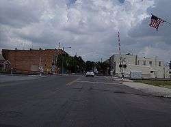 Looking northward along Main Street in downtown Dunkirk | |
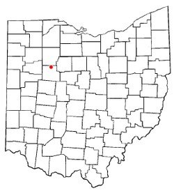 Location of Dunkirk, Ohio | |
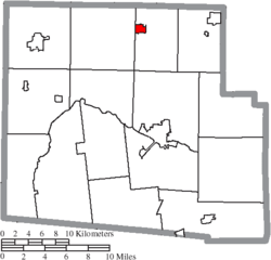 Location of Dunkirk in Hardin County | |
| Coordinates: 40°47′19″N 83°38′41″W | |
| Country | United States |
| State | Ohio |
| County | Hardin |
| Township | Blanchard |
| Area | |
| • Total | 0.72 sq mi (1.85 km2) |
| • Land | 0.66 sq mi (1.70 km2) |
| • Water | 0.06 sq mi (0.15 km2) |
| Elevation | 945 ft (288 m) |
| Population | |
| • Total | 875 |
| • Estimate (2019)[4] | 840 |
| • Density | 1,278.54/sq mi (493.90/km2) |
| Time zone | UTC-5 (Eastern (EST)) |
| • Summer (DST) | UTC-4 (EDT) |
| ZIP code | 45836 |
| Area code(s) | 419 |
| FIPS code | 39-22946[5] |
| GNIS feature ID | 1039880[2] |
History
Dunkirk was platted in 1852 when the railroad was extended to that point.[6] The village was named after Dunkirk, New York.[6] A post office has been in operation at Dunkirk since 1854.[7]
In 2006, Dunkirk was identified by the Ohio Department of Transportation as a potential junction for the Ohio Hub high-speed rail project.[8]
Geography
Dunkirk is located at 40°47′19″N 83°38′41″W (40.788588, -83.644688).[9]
According to the United States Census Bureau, the village has a total area of 0.72 square miles (1.86 km2), of which, 0.66 square miles (1.71 km2) is land and 0.06 square miles (0.16 km2) is water.[10]
Demographics
| Historical population | |||
|---|---|---|---|
| Census | Pop. | %± | |
| 1880 | 1,311 | — | |
| 1890 | 1,220 | −6.9% | |
| 1900 | 1,222 | 0.2% | |
| 1910 | 1,109 | −9.2% | |
| 1920 | 894 | −19.4% | |
| 1930 | 905 | 1.2% | |
| 1940 | 922 | 1.9% | |
| 1950 | 972 | 5.4% | |
| 1960 | 1,006 | 3.5% | |
| 1970 | 1,036 | 3.0% | |
| 1980 | 954 | −7.9% | |
| 1990 | 869 | −8.9% | |
| 2000 | 952 | 9.6% | |
| 2010 | 875 | −8.1% | |
| Est. 2019 | 840 | [4] | −4.0% |
| U.S. Decennial Census[11] | |||
2010 census
As of the census[3] of 2010, there were 875 people, 332 households, and 234 families living in the village. The population density was 1,325.8 inhabitants per square mile (511.9/km2). There were 386 housing units at an average density of 584.8 per square mile (225.8/km2). The racial makeup of the village was 97.4% White, 0.3% African American, 0.3% Native American, 0.5% Asian, and 1.5% from two or more races. Hispanic or Latino of any race were 0.5% of the population.
There were 332 households, of which 37.0% had children under the age of 18 living with them, 54.8% were married couples living together, 10.2% had a female householder with no husband present, 5.4% had a male householder with no wife present, and 29.5% were non-families. 25.3% of all households were made up of individuals, and 10.5% had someone living alone who was 65 years of age or older. The average household size was 2.64 and the average family size was 3.12.
The median age in the village was 35.5 years. 28.1% of residents were under the age of 18; 7.4% were between the ages of 18 and 24; 26.8% were from 25 to 44; 25.6% were from 45 to 64; and 12.1% were 65 years of age or older. The gender makeup of the village was 50.2% male and 49.8% female.
2000 census
As of the census[5] of 2000, there were 952 people, 361 households, and 276 families living in the village. The population density was 1,428.6 people per square mile (548.6/km2). There were 396 housing units at an average density of 594.3 per square mile (228.2/km2). The racial makeup of the village was 98.63% White, 0.11% Native American, 0.21% Asian, and 1.05% from two or more races. Hispanic or Latino of any race were 0.21% of the population.
There were 361 households, out of which 38.2% had children under the age of 18 living with them, 60.9% were married couples living together, 10.8% had a female householder with no husband present, and 23.3% were non-families. 21.1% of all households were made up of individuals, and 11.1% had someone living alone who was 65 years of age or older. The average household size was 2.63 and the average family size was 2.97.
In the village, the population was spread out, with 27.6% under the age of 18, 9.8% from 18 to 24, 28.6% from 25 to 44, 21.4% from 45 to 64, and 12.6% who were 65 years of age or older. The median age was 34 years. For every 100 females there were 102.6 males. For every 100 females age 18 and over, there were 90.9 males.
The median income for a household in the village was $39,423, and the median income for a family was $45,000. Males had a median income of $38,083 versus $20,000 for females. The per capita income for the village was $16,899. About 4.6% of families and 9.3% of the population were below the poverty line, including 14.5% of those under age 18 and 6.4% of those age 65 or over.
Notable residents
- Dean Pees, NFL coach
- Willard Rhodes, ethnomusicologist
References
- "2019 U.S. Gazetteer Files". United States Census Bureau. Retrieved July 28, 2020.
- "US Board on Geographic Names". United States Geological Survey. 2007-10-25. Retrieved 2008-01-31.
- "U.S. Census website". United States Census Bureau. Retrieved 2013-01-06.
- "Population and Housing Unit Estimates". United States Census Bureau. May 24, 2020. Retrieved May 27, 2020.
- "U.S. Census website". United States Census Bureau. Retrieved 2008-01-31.
- Kohler, Minnie Ichler (1910). A Twentieth Century History of Hardin County, Ohio: A Narrative Account of Its Historical Progress, Its People and Principal Interests,. Lewis Publishing Company. p. 170.
- "Hardin County". Jim Forte Postal History. Archived from the original on 22 December 2015. Retrieved 14 December 2015.
- "Ohio Hub Incremental Routes" (PDF). Ohio Department of Transportation. October 17, 2006. p. 23. Archived from the original (pdf) on January 1, 2009. Retrieved 2009-09-12.
- "US Gazetteer files: 2010, 2000, and 1990". United States Census Bureau. 2011-02-12. Retrieved 2011-04-23.
- "US Gazetteer files 2010". United States Census Bureau. Archived from the original on 2012-07-02. Retrieved 2013-01-06.
- "Census of Population and Housing". Census.gov. Retrieved June 4, 2015.
External links
Municipalities and communities of Hardin County, Ohio, United States | ||
|---|---|---|
| City | 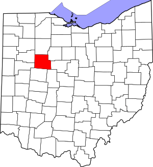 Map of Ohio highlighting Hardin County | |
| Villages | ||
| Townships | ||
| CDP | ||
| Unincorporated communities | ||
| Footnotes | ‡This populated place also has portions in an adjacent county or counties | |
| Authority control |
|
|---|