Hajigabul District
Hajigabul (Azerbaijani: Hacıqabul) is one of the districts of Azerbaijan established in 1990 by the decision of the Supreme Council of the Republic. The district is bordered by Absheron, Gobustan, Shamaxı, Aghsu, Kurdamir, Sabirabad, Salyan, and Shirvan city.
Hacıqabul | |
|---|---|
.svg.png) Map of Azerbaijan showing Hajigabul rayon | |
| Country | |
| Capital | Hajiqabul |
| Area | |
| • Total | 1,640 km2 (630 sq mi) |
| Population (2009) | |
| • Total | 65,500 |
| Postal code | 2400 |
| Telephone code | (+994) 21[1] |
History
Hajigabul district located on the Silk Road, was part of the Arab Caliphate, Seljuk, Sacids, Hulakids, Shirvanshahs, Safavids in different times. During the division of the State into the Khanates, the district was included in the Shamakhi khanate. After joining of North Azerbaijan to Tsardom of Russia,[2] it was included in Shamakhi Uyezd of Caspian province which was established in 1830.[3] After the abolition of the Caspian province in 1841, it was included in the Shamakhi governorate. After the devastating earthquake in 1859 in Shamakhi, the capital of governorate was moved to Baku. In 1860 - 1930, Hajigabul was part of the Shamakhi Uyezd in the Baku province. On August 8, 1930, Uyezd was abolished and as a result of this, the new Garasu was established. Since November 29, 1938, city status has been awarded to Hajigabul.[4][5]
Divisions
There are 31 populated areas. One of them is a city, 1 city-like settlement, 4 settlements and 25 villages. There are 15 administrative-territorial units, 5 medical institutions and 55 cultural centers. The Pirsaat River and Prsaat valley is located in this region.[6]
Population
According to the report of Statistical Committee of republic, the number of population is 74,7 thousand at the beginning of the 2018. 37,4 thousand of them live in urban areas, 37,3 thousand people in the rural areas.[7]
| Population | 1999 | 2000 | 2001 | 2002 | 2003 | 2004 | 2005 | 2006 | 2007 | 2008 | 2009 | 2010 | 2011 | 2012 | 2013 | 2014 | 2015 | 2016 | 2017 | 2018 |
|---|---|---|---|---|---|---|---|---|---|---|---|---|---|---|---|---|---|---|---|---|
| Hajigabul region | 57,9 | 58,5 | 59,1 | 59,7 | 60,2 | 60,7 | 61,7 | 63,0 | 63,9 | 64,8 | 65,7 | 66,5 | 67,3 | 68,3 | 69,1 | 70,1 | 71,2 | 72,5 | 73,6 | 74,7 |
| urban areas | 26,4 | 26,8 | 27,1 | 27,3 | 27,6 | 31,7 | 32,2 | 32,6 | 33,0 | 33,4 | 33,8 | 34,1 | 34,5 | 34,8 | 35,2 | 35,5 | 36,0 | 36,5 | 37,0 | 37,4 |
| rural areas | 31,5 | 31,7 | 32,0 | 32,4 | 32,6 | 29,0 | 29,5 | 30,4 | 30,9 | 31,4 | 31,9 | 32,4 | 32,8 | 33,5 | 33,9 | 34,6 | 35,2 | 36,0 | 36,6 | 37,3 |
Economy
The Baku-Tbilisi railway and 82 km of the Silk Road pass through the region. Over 35 state and private institutions operate in the Hajigabul. The largest of these institutions is Department of the operation of Kura Water pipelines. It was opened in 1971. It provides the surrounding areas and capital of country with drinking water. The Gas Pipeline Production Department and the "Kalmaz" Underground Gas Storage meet the natural gas demand of the Republic. Railway institution operates in the district. Poultry farms named "Adishirin" and "Pirsaat" meet the egg demand of Hajigabul and nearby areas. The both farms have been operating since the independence period.[9] Although the economy of region is based on agriculture, recently an automobile plant put into operation in Hajigabul Industrial Estate based on the cooperation between Russian Gas Group and Azermash OJSC. Additionally, according to the order of the president of Republic of Azerbaijan dated to 2017, an industrial district will be established in Hajigabul which is considered to developed and regulated by Azerbaijan Investment Company OJSC.[10][11]
Agriculture
Agriculture plays key role in the economy of district which includes livestock, grain growing, cotton growing, horticulture and especially melon and watermelon growing.[12]
| Agriculture | ||||||
| 2010 | 2013 | 2014 | 2015 | 2016 | 2017 | |
| Total area of sown agricultural crops (ha) | ||||||
| Cereals and cereal legumes | 9171 | 12377 | 12689 | 12919 | 14179 | 15216 |
| Including wheat | 4730 | 6288 | 6415 | 6475 | 7130 | 7478 |
| Cotton | - | - | - | - | 526 | 1204 |
| Sugar beet | - | - | - | - | 160 | 556 |
| Sunflower for seed production | 24 | 78 | 75 | 49 | - | - |
| Potato | - | 38 | 38 | 39 | 40 | 42 |
| Vegetables | 520 | 728 | 761 | 776 | 781 | 442 |
| Horticulture | 1038 | 1618 | 1579 | 1572 | 1572 | 828 |
| Fruit and berry | 1303 | 1431 | 1431 | 1431 | 1437 | 1437 |
| Grape | 98 | 115 | 115 | 115 | 115 | 115 |
| Productivity (in all categories of farming), ton | ||||||
| Cereals and cereal legumes | 26874 | 37010 | 37909 | 44146 | 51241 | 50329 |
| Including wheat | 16110 | 21865 | 22213 | 24735 | 25922 | 24136 |
| Cotton | - | - | - | - | 800 | 1000 |
| Sugar beet | - | - | - | - | 5400 | 22821 |
| Sunflower for seed production | 29 | 103 | 102 | 67 | - | - |
| Potato | - | 417 | 418 | 428 | 451 | 461 |
| Vegetables | 13540 | 18959 | 19818 | 20216 | 20431 | 7295 |
| Horticulture | 15258 | 23882 | 23306 | 23306 | 23428 | 11675 |
| Fruit and berry | 5850 | 10997 | 11051 | 11057 | 11205 | 11314 |
| Grape | 180 | 252 | 253 | 264 | 261 | 262 |
| Productivity (in all categories of farming), centner / ha | ||||||
| Cereals and cereal legumes | 29.3 | 29.9 | 29.9 | 34.2 | 34.8 | 32.9 |
| Including wheat | 34.1 | 34.8 | 34.6 | 38.2 | 36.4 | 32.3 |
| Cotton | - | - | - | - | 15.2 | 8.3 |
| Sugar beet | - | - | - | - | 388 | 459 |
| Sunflower for seed production | 12.1 | 13.2 | 13.6 | 13.7 | - | - |
| Potato | - | 110 | 110 | 110 | 110 | 110 |
| Vegetables | 260 | 260 | 260 | 260 | 260 | 157 |
| Horticulture | 147 | 148 | 148 | 148 | 148 | 141 |
| Fruit and berry | 47.8 | 80.8 | 81.2 | 81.2 | 78.8 | 80.2 |
| Grape | 21.2 | 29.1 | 29.1 | 29.1 | 22.8 | 22.8 |
| Number of Livestock (in total) | ||||||
| Cattle | 35163 | 37241 | 37508 | 37819 | 38414 | 38798 |
| Including cow and buffalo | 14948 | 15675 | 15858 | 15990 | 16245 | 16424 |
| Sheep and goats | 124600 | 132325 | 133765 | 134838 | 135956 | 136906 |
| Birds | 1377872 | 2870130 | 3632510 | 4637392 | 3414135 | 3798969 |
| Production of animal products, ton | ||||||
| Meat | 2817 | 3418 | 5777 | 5984 | 6175 | 5360 |
| Milk | 13800 | 17168 | 17172 | 17217 | 17242 | 17253 |
| Eggs | 113480 | 280355 | 327071 | 331199 | 327143 | 350497 |
| Wool | 206 | 223 | 224 | 225 | 225 | 228 |
Geography
Hajigabul district mainly is located in the Shirvan plain and it is below the sea level. The Neocene and Anthropogenic sediments covers the surface of the plain. The soil of the region is composed of gray-brown, gray-meadow, saline soils. Like other regions of Aran Economic region, it is also possible to encounter mud volcanoes in Hajigabul district. Oil, gas, clay and oak are the main minerals of the region. The river system is very sparse due to its climate. The Kur and Pirsaat rivers, Hajigabul Lake are the major water sources is in the territory of the region. The vegetation is half-desert type. The gazelles, the red-tailed sandwiches, the turtle, the turquoise and the pigeon are the typical animals of the district.[13][14]
Climate
Hajigabul district has dry subtropical climate with hot summers and cool winters, with some to minimal precipitation. The level of precipitation heavily depends on seasonality so that the region receives considerably more rains during winter period rather than in summer time. The average temperature is 2 °C in January and 26 °C in July, respectively.[15]
Gallery
- Hacigabul
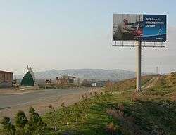 Road from Shirvan reaching Hajigabul Rayon. Hacıqabul city (or Qazıməmməd) in the background
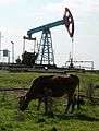 Onshore oil in the vicinity of Hacigabul
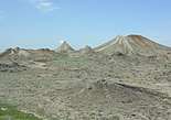 Haciqabul mud volcanoes
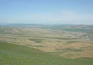 Pirsaat valley
References
- "Şəhərlərarası telefon kodları". Aztelekom MMC. Aztelekom İB. Retrieved 19 August 2015. (in Azerbaijani)
- "History of Azerbaijan" (PDF).
- "Hacıqabul rayonunun tarixi" [History of Hajigabul district]. haciqabul-ih.gov.az. Retrieved 2018-08-29.
- "Hajigabul district". Official webpage of Azerbaijan National Library (in Azerbaijani).
- "Library branch#1 of Hajigabul region". cls.az (in Azerbaijani). Retrieved 2018-08-30.
- "Villages of Hajigabul".
- "Political division, population size and structure: Economic and administrative regions and towns- Population by sex, towns and regions, urban settlements of the Republic of Azerbaijan at the beginning of 2018".
- "Political division, population size and structure: Economic and administrative regions and towns - Population by towns and regions of the Republic of Azerbaijan".
- "Information on the administrative-territorial unit : Hajygabul".
- "The foundation of the automobile plant in Hajigabul Industrial Estate was laid".
- "Socio-economic development of the regions" (PDF).
- "Hacıqabul rayonu".
- "Geography".
- "Kur-Araz natural-economic zones. Aran (Kur-Araz) economic region".
- "The climate of Azerbaijan".