Gerger
Gerger (Kurdish: Aldûş,[3] Armenian: Կարկառ, romanized: Karkaṙ) is a town and a district of Adıyaman Province of Turkey. The mayor is Zeynal Aslan (SP).
Gerger | |
|---|---|
 Gerger | |
| Coordinates: 38°01′44″N 39°01′56″E | |
| Country | Turkey |
| Province | Adıyaman |
| Government | |
| • Mayor | Zeynal Aslan (SP) |
| • Kaymakam | Alp Eren Yılmaz |
| Area | |
| • District | 702.43 km2 (271.21 sq mi) |
| Population (2012)[2] | |
| • Urban | 3,165 |
| • District | 22,526 |
| • District density | 32/km2 (83/sq mi) |
| Post code | 02700 |
| Website | www.gerger.bel.tr |
History
According to some sources, in the first half of the 6th Century BCE, during the reign of King Seleucus Arsemes, a city named Arsemia was built on the Euphrates. As this city still has Gerger Castle. Arsemia Kommagene down with the king, the city used as winter time.
This area during the Byzantine Empire changed hands. On these dates, the general public of the Christian religion is based on the Gregorian sectarian, in the year 135 Hijri the caliph Abu Jafar-Abbes el Mansur's Adiyaman, Kahta and the conquest see here are together Samsatla.
In 2018, archaeologists discovered a cave which used during religious ceremonies by Christians during the Byzantine period. Cross figures found inside the cave.[4]
Population
| Yıl | Total | Districts | Village |
|---|---|---|---|
| 2010 | 24.622 | 3.235 | 21.387 |
| 2009 | 25.440 | 3.242 | 22.198 |
| 2008 | 25.769 | 3.472 | 22.297 |
| 2007 | 25.811 | 4.059 | 21.752 |
| 2000 | 27.208 | 4.223 | 22.985 |
| 1990 | 32.587 | 3.854 | 28.733 |
| 1985 | 32.618 | 4.221 | 28.397 |
| 1980 | 30.380 | 3.704 | 26.676 |
| 1975 | 30.820 | 2.773 | 28.047 |
| 1970 | 29.395 | 2.279 | 27.116 |
| 1965 | 26.723 | 1.229 | 25.494 |
References
- "Area of regions (including lakes), km²". Regional Statistics Database. Turkish Statistical Institute. 2002. Retrieved 2013-03-05.
- "Population of province/district centers and towns/villages by districts - 2012". Address Based Population Registration System (ABPRS) Database. Turkish Statistical Institute. Retrieved 2013-02-27.
- Adem Avcıkıran (2009). Kürtçe Anamnez Anamneza bi Kurmancî (PDF) (in Turkish and Kurdish). p. 56. Retrieved 17 December 2019.
- Roman-era cave found in Adıyaman
Gerger in Adıyaman Province of Turkey | |||||||||||||||||||||||||||
|---|---|---|---|---|---|---|---|---|---|---|---|---|---|---|---|---|---|---|---|---|---|---|---|---|---|---|---|
| Districts | 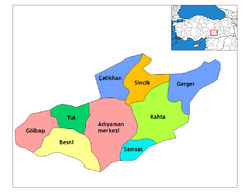 Districts of Adıyaman | ||||||||||||||||||||||||||
| |||||||||||||||||||||||||||
Metropolitan municipalities are bolded. | |||||||||||||||||||||||||||