Freeman Street station
Freeman Street is a local station on the IRT White Plains Road Line of the New York City Subway. Located at the intersection of Freeman Street and Southern Boulevard in the Bronx, it is served by the 2 train at all times, and the 5 train at all times except late nights and rush hours in the peak direction.
Freeman Street | |||||||||
|---|---|---|---|---|---|---|---|---|---|
 Platform level | |||||||||
| Station statistics | |||||||||
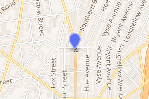
| Address | Freeman Street & Southern Boulevard Bronx, NY 10459 | ||||||||
| Borough | The Bronx | ||||||||
| Locale | Crotona Park East, East Morrisania | ||||||||
| Coordinates | 40.83°N 73.892°W | ||||||||
| Division | A (IRT) | ||||||||
| Line | IRT White Plains Road Line | ||||||||
| Services | 2 5 | ||||||||
| Transit connections | |||||||||
| Structure | Elevated | ||||||||
| Platforms | 2 side platforms | ||||||||
| Tracks | 3 | ||||||||
| Other information | |||||||||
| Opened | November 26, 1904 (3rd Ave. Line; Bergen Avenue By-pass) July 10, 1905 (White Plains Rd. Line) | ||||||||
| Station code | 429[1] | ||||||||
| Opposite-direction transfer available | No | ||||||||
| Traffic | |||||||||
| Passengers (2019) | 1,358,821[2] | ||||||||
| Rank | 316 out of 424[2] | ||||||||
| Station succession | |||||||||
| Next north | 174th Street: 2 | ||||||||
| Next south | Simpson Street: 2 | ||||||||
| |||||||||
| |||||||||
| |||||||||

History
The initial segment of the IRT White Plains Road Line opened on November 26, 1904 between 180th Street–Bronx Park and Jackson Avenue. Initially, trains on the line were served by elevated trains from the IRT Second Avenue Line and the IRT Third Avenue Line. Once the connection to the IRT Lenox Avenue Line opened on July 10, 1905, trains from the newly opened IRT subway ran via the line.[3][4][5]
The Bergen Avenue cutoff, which allowed Third Avenue trains to access the White Plains Road Line, was abandoned on November 5, 1946, as part of the gradual curtailment of elevated service on the IRT Third Avenue Line.[4] On June 13, 1949, the platform extensions at this station, as well as those on White Plains Road Line stations between Jackson Avenue and 177th Street, opened. The platforms were lengthened to 514 feet (157 m) to allow full ten-car express trains to open their doors. Previously, the stations could only platform six-car local trains.[6]
The station was renovated in 2004.
Station layout
| P Platform level |
Side platform | |
| Northbound local | ← ← | |
| Peak-direction express | ← | |
| Southbound local | | |
| Side platform | ||
| G | Street level | Exit/entrance |
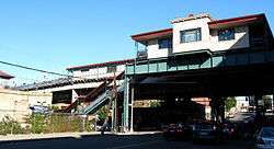
This elevated station, which resembles the Prospect Avenue station, has three tracks and two curved side platforms.
As with other original IRT elevated viaducts, the elevated structure at Freeman Street is carried on two column bents, one on each side of the road, at places where the tracks are no more than 29 feet (8.8 m) above the ground level. There is zigzag lateral bracing at intervals of every four panels.[7]
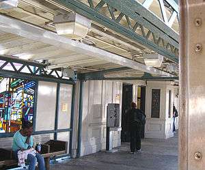
The MTA Arts & Design artwork at this station consists of 4 faceted-glass windbreaks and 2 niche windows designed by the artist Daniel Hauben. The windbreaks were fabricated by Gordon Stained Glass Studios.
Exits
The station has heaters, as well as a wooden mezzanine, floor, and open old booth similar to the one at Simpson Street. Exits lead to all corners of Freeman Street and Southern Boulevard.[8]
References
- "Station Developers' Information". Metropolitan Transportation Authority. Retrieved June 13, 2017.
- "Facts and Figures: Annual Subway Ridership 2014–2019". Metropolitan Transportation Authority. 2020. Retrieved May 26, 2020.
- "Discuss Subway Signs in 18th St. Station" (PDF). The New York Times. November 27, 1904. ISSN 0362-4331. Archived (PDF) from the original on March 24, 2020.
- Kahn, Alan Paul (January 1, 1973). Tracks of New York /. New York : Electric Railroaders' Association.
- "Subway Trains Running From Bronx to Battery" (PDF). The New York Times. July 10, 1905. ISSN 0362-4331. Archived (PDF) from the original on March 24, 2020. Retrieved September 4, 2016.
- Report for the three and one-half years ending June 30, 1949. New York City Board of Transportation. 1949. hdl:2027/mdp.39015023094926.
- Transit Journal. 1904. p. 470. Retrieved 2020-04-16.

- "Freeman Street Neighborhood Map" (PDF). new.mta.info. Metropolitan Transportation Authority. April 2018. Retrieved February 28, 2019.
External links
| Wikimedia Commons has media related to Freeman Street (IRT White Plains Road Line). |
- nycsubway.org – IRT White Plains Road Line: Freeman Street
- nycsubway.org — The El Artwork by Daniel Hauben (2005)
- Station Reporter — 2 Train
- Station Reporter — 5 Train
- The Subway Nut — Freeman Street Pictures
- MTA's Arts For Transit — Freeman Street (IRT White Plains Road Line)
- Freeman Street entrance from Google Maps Street View
- Platforms from Google Maps Street View (at Night)
- Platforms from Google Maps Street View (Daytime)
| White Plains Rd. Line |
|
|---|---|
| |