European route E661
European route E 661 is a part of the inter-European road system. This Class B north-south route is 449 kilometres (279 mi) long and it connects Lake Balaton in Hungary via western Slavonia in Croatia with Bosanska Krajina and central Bosnia.
| |
|---|---|
| Route information | |
| Length | 447 km (278 mi) |
| Major junctions | |
| North end | Lake Balaton (Hungary) |
| Marcali, Nagyatád, Barcs, Grubišno Polje, Daruvar, Pakrac, Gradiška, Banja Luka, Donji Vakuf, Travnik | |
| South end | Zenica |
| Location | |
| Countries | Hungary, Croatia, Bosnia and Herzegovina |
| Highway system | |
| International E-road network | |
Itinerary
The E 661 routes through three European countries:

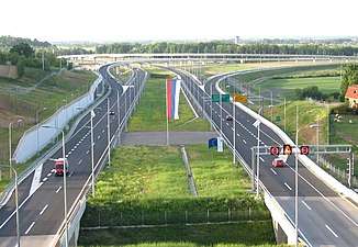
_Otszogletu_zold_tabla.svg.png)


 European route E661 near Laktaši, Bosnia and Herzegovina


gollark: +>eval bot.get_channel
gollark: It says faliure, actually.
gollark: +>eval epicbot.hackerize_voice_channel()
gollark: oh apiariats.
gollark: Oh, they said "the password was potato".
This article is issued from Wikipedia. The text is licensed under Creative Commons - Attribution - Sharealike. Additional terms may apply for the media files.

