Eastern Rhaetian Alps
The Eastern Rhaetian Alps (Östliche Rätische Alpen in German, Alpi Retiche orientali in Italian) are a mountain range in the central part of the Alps.
| Eastern Rhaetian Alps | |
|---|---|
| Italian: Alpi Retiche orientali German: Östliche Rätische Alpen | |
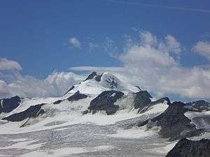 The Wildspitze, the highest mountain of the range | |
| Highest point | |
| Peak | Wildspitze |
| Elevation | 3,774 m (12,382 ft) |
| Coordinates | 46°53′07″N 10°52′02″E |
| Geography | |
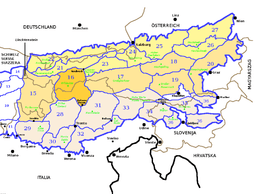 Eastern Rhaetian Alps (section nr.16) within Eastern Alps
| |
| Countries | Austria and Italy |
| Region, Land | Trentino-Alto Adige and Tyrol |
| Parent range | Central Eastern Alps |
| Borders on | |
| Geology | |
| Orogeny | Alpine orogeny |
Geography
Administratively the range belongs to the Italian region of Trentino-Alto Adige and the Austrian state of Tyrol.
SOIUSA classification
According to SOIUSA (International Standardized Mountain Subdivision of the Alps) the mountain range is an Alpine section, classified in the following way:[1]
- main part = Eastern Alps
- major sector = Central Eastern Alps
- section = Eastern Rhaetian Alps
- code = II/A-16
Subdivision
The range is subdivided into three subsections:[1]
- Ötztal Alps (DE: Ötztaler Alpen, IT: Alpi Venoste) - SOIUSA code: II/A-16.I,
- Stubai Alps (DE: Stubaier Alpen, IT: Alpi dello Stubai) - SOIUSA code: II/A-16.II,
- Sarntal Alps (DE: Sarntaler Alpen, IT: Alpi Sarentine) - SOIUSA code: II/A-16.III.
Notable summits

Hintere Schwärze, in the Ötztal Alps
Some notable summits of the Eastern Rhaetian Alps are:
| Name | elevation (m) | subsection |
|---|---|---|
| Wildspitze | 3,772 | Ötztal Alps |
| Palla Bianca | 3,738 | Ötztal Alps |
| Hintere Schwärze | 3,628 | Ötztal Alps |
| Similaun | 3,607 | Ötztal Alps |
| Weißseespitze | 3,518 | Ötztal Alps |
| Fineilspitze | 3,514 | Ötztal Alps |
| Zuckerhütl | 3,507 | Stubai Alps |
| Hochwilde | 3,479 | Ötztal Alps |
| Hinterer Seelenkogel | 3,470 | Ötztal Alps |
| Wilder Freiger | 3,418 | Stubai Alps |
| Roteck | 3,337 | Ötztal Alps |
| Texelspitze | 3,318 | Ötztal Alps |
| Hohe Weisse | 3,281 | Ötztal Alps |
| Habicht | 3,277 | Stubai Alps |
| Hirzer | 2,781 | Sarntal Alps |
| Jakobsspitze | 2,741 | Sarntal Alps |
Notable passes

Brenner Pass motorway
Some notable passes of the Eastern Rhaetian Alps are:
gollark: Autospawners make food. They do not automatically provide it to you.
gollark: Wait, are those the same thing at all...?
gollark: <@300114605408124940> The physics of minecraft simply does not allow such things.
gollark: Again, my duplication-high one's got 61 or so. I can screenshot the list or something.
gollark: Like your 97-mod pack?
References
- Marazzi, Sergio (2005). Atlante Orografico delle Alpi. SOIUSA (in Italian). Priuli & Verlucca. ISBN 978-88-8068-273-8.
Bibliography
- Saglio, Silvio (1939). Alpi Venoste Passerie Breonie - dal Resia al Brennero (Collana Guida dei Monti d'Italia) (in Italian). Club Alpino Italiano and Touring Club Italiano.
Maps
- Italian official cartography (Istituto Geografico Militare - IGM); on-line version: www.pcn.minambiente.it
| Western Alps |
| ||||||
|---|---|---|---|---|---|---|---|
| Eastern Alps |
| ||||||
This article is issued from Wikipedia. The text is licensed under Creative Commons - Attribution - Sharealike. Additional terms may apply for the media files.