Carinthian-Styrian Alps
The Carinthian-Styrian Alps (in German Steirisch-Kärntnerische Alpen or Gurk-und Lavanttaler Alpen) are a mountain range in the eastern part of the Alps. They are located in Austria.
| Carinthian-Styrian Alps | |
|---|---|
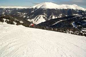 The Eisenhut in winter | |
| Highest point | |
| Peak | Eisenhut |
| Elevation | 2,241 m (7,352 ft) |
| Coordinates | 46°57′12″N 13°55′34″E |
| Naming | |
| Native name | Steirisch-Kärntnerische Alpen, Gurk-und Lavanttaler Alpen |
| Geography | |
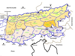 Carinthian-Styrian Alps (section nr.19) within Eastern Alps
| |
| Country | Austria |
| States of Austria | Styria, Carinthia, Salzburg |
| Parent range | Alps |
| Borders on | List
|
| Geology | |
| Orogeny | Alpine orogeny |
Geography
Administratively the range belongs to the Austrian state of Styria, Carinthia and, marginally, to Salzburg. Its whole area is drained by the tributaries of the Danube river.
SOIUSA classification
According to SOIUSA (International Standardized Mountain Subdivision of the Alps) the Carinthian-Styrian Alps are an Alpine section, classified in the following way:[1]
- main part = Eastern Alps
- major sector = Central Eastern Alps
- section = Carinthian-Styrian Alps
- SOIUSA code = II/A-19
Subdivision
The Carinthian-Styrian Alps are divided in two subsections:
- Gurktal Alps - SOIUSA code: II/A-19.I
- Lavanttal Alps - SOIUSA code: II/A-19.II
Notable summits

Mount Großer Rosennock
Some notable summits of the Carinthian-Styrian Alps are:
| Name | metres | feet |
|---|---|---|
| Eisenhut | 2,441 | 8,006 |
| Großer Rosennock | 2,440 | 8,003 |
| Kilnprein | 2,408 | 7,898 |
| Zirbitzkogel | 2,396 | 7,858 |
| Mirnock | 2,110 | 6,920 |
| Ulrichsberg | 1,022 | 3,352 |
gollark: <@89956374426976256> It does ask, but Discord's "friendly" language obfuscates what it's asking you to do a lot.
gollark: It *was* you who asked, right?
gollark: https://gist.github.com/marcan/6dde73a9a0c917cd4fc9784a0a73efe3https://www.raspberrypi.org/forums/viewtopic.php?f=43&t=178038&hilit=camera+drm<@!261154480433659914>
gollark: I've found one thing vaguely referencing it on the project log of someone who reverse engineered it, but... that's it?
gollark: This is proving oddly hard to find.
References
- Marazzi, Sergio (2005). Atlante Orografico delle Alpi. SOIUSA (in Italian). Priuli & Verlucca. ISBN 978-88-8068-273-8.
| Western Alps |
| ||||||
|---|---|---|---|---|---|---|---|
| Eastern Alps |
| ||||||
This article is issued from Wikipedia. The text is licensed under Creative Commons - Attribution - Sharealike. Additional terms may apply for the media files.