Habicht
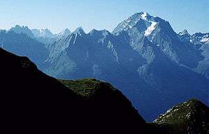
The Habicht is a mountain in the Stubai Alps of Austria. For a long time, the locals believed it to be the highest mountain in Tyrol, due to its prominence above the surrounding mountains. Despite what they thought, the highest peak in the Stubai Alps is Zuckerhütl which is 230 metres higher than Habicht. The name literally means "hawk" in German.
| Habicht | |
|---|---|
 | |
| Highest point | |
| Elevation | 3,277 m (10,751 ft) |
| Prominence | 557 m (1,827 ft) [1] |
| Isolation | 10.1 km (6.3 mi) |
| Coordinates | 47°2′38″N 11°17′23″E |
| Geography | |
| Location | Tyrol, Austria |
| Parent range | Stubai Alps |
| Topo map | BEV ÖK50 147 |
| Climbing | |
| First ascent | 1836 by Thurwieser and Krösbacher |
| Easiest route | Scramble |
Climbing
- Starting point: Innsbrucker Hütte (2369 m)
- Height gain: 908 m
- Difficulty level: non-trivial; portions secured by cables (which may be buried in snowy conditions), part of the route from 3100-3200m leads over snow-field [2]
- Duration: 3 hours ascent, plus or minus depending on weather and experience[3]
gollark: This has been found to be isomorphic to Macron.
gollark: Just fix that and then do it.
gollark: Unless you just directly inject it through your skull.
gollark: Well, you might have to do it a bit beforehand, I assume.
gollark: My field is apiomemetics, apiology, and apiodynamics, not "medicine" on "humans".
References
- "Habicht - Peakvisor". peakvisor.com. Retrieved 25 May 2020.
- http://www.summitpost.org/normal-route-from-innsbruck-hut/156608
- www.tyrol.com
This article is issued from Wikipedia. The text is licensed under Creative Commons - Attribution - Sharealike. Additional terms may apply for the media files.