Demir Kapija Municipality
Demir Kapija (Macedonian: Демир Капија [ˌdɛmir ˈkapija] (![]()
Demir Kapija Municipality Општина Демир Капија | |
|---|---|
Urban municipality | |
 Flag  Coat of arms | |
 | |
| Coordinates: 41°24′32″N 22°14′38″E | |
| Country | |
| Region | |
| Municipal seat | Demir Kapija |
| Government | |
| • Mayor | Trajche Dimitriev (VMRO-DPMNE) |
| Area | |
| • Total | 311.06 km2 (120.10 sq mi) |
| Elevation | 202 m (663 ft) |
| Population | |
| • Total | 4,545 |
| • Density | 15/km2 (38/sq mi) |
| Time zone | UTC+1 (CET) |
| Postal Code | 1442 |
| Area Code | 034 |
| Vehicle registration | DK |
| Website | www |
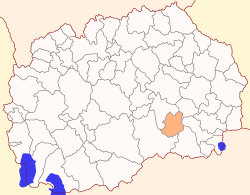
Geography
The municipality borders
- Negotino Municipality to the northwest,
- Konče Municipality to the northeast,
- Valandovo Municipality to the east,
- Gevgelija Municipality to the southeast, and
- Kavadarci Municipality to the southwest.
Demographics
According to the last national census from 2002 this municipality has 4,545 inhabitants.[1]
Ethnic groups in the municipality include:
- Macedonians = 3,997 (87.9%)
- Turks = 344 (7.6%)
- Serbs = 132 (2.9%)
- others.
Populated settlements include:
- Demir Kapija (seat)
- Čelevec
- Čiflik
- Barovo
- Besvica
- Bistrenci
- Dračevica
- Dren
- Iberli
- Klisura
- Košarka
- Koprišnica
- Korešnica
- Prždevo
- Strmaševo
gollark: Go implement that then?
gollark: GTech™ has your location accurately enough to fire orbital lasers through apiospatial wormholes.
gollark: We may have broken a few researchers' projects through making the citation graphs cyclic.
gollark: The other 26 are wrong.
gollark: Oh, we retroactively overwrote 1294712849 style guides.
References
- 2002 census results in English and Macedonian (PDF)
| Eastern | ||
|---|---|---|
| Norteastern | ||
| Pelagonia | ||
| Polog | ||
| Skopje | ||
| Southeastern | ||
| Southwestern | ||
| Vardar | ||
| City of Skopje |
| |
| Former |
| |
This article is issued from Wikipedia. The text is licensed under Creative Commons - Attribution - Sharealike. Additional terms may apply for the media files.