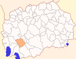
Demir Hisar Municipality
Demir Hisar (Macedonian: Демир Хисар [dɛˈmir‿xisar] (![]()
Municipality of Demir Hisar Општина Демир Хисар | |
|---|---|
Municipality | |
 Flag  Coat of arms | |
 | |
| Country | |
| Region | |
| Municipal seat | Demir Hisar |
| Government | |
| • Mayor | Marjance Stojanovski (SDSM) |
| Area | |
| • Total | 480.13 km2 (185.38 sq mi) |
| Population | |
| • Total | 9,497 |
| • Density | 20/km2 (51/sq mi) |
| Time zone | UTC+1 (CET) |
| Area code(s) | 47 |
| car plates | BT |
Geography
The municipality borders Kičevo Municipality to the north, Kruševo Municipality and Mogila Municipality to the east, Bitola Municipality to the south, and Resen Municipality, Ohrid Municipality, and Debarca Municipality to the west.
Demographics
According to the last national census from 2002 this municipality has 9,497 inhabitants.[1]
Ethnic groups in the municipality include:
- Macedonians = 9,179 (96.7%)
- Albanians = 232 (2.4%)
- Turks = 35 (0,4%)
- others.
gollark: ... broadly speaking...
gollark: Training will be slow but we can do inference fast if I use AVX or something and a small model.
gollark: Not necessarily!
gollark: Probably actually having to read the papers can, but still.
gollark: You can't stop me.
References
- 2002 census results in English and Macedonian (PDF)
External links
| Eastern | ||
|---|---|---|
| Norteastern | ||
| Pelagonia | ||
| Polog | ||
| Skopje | ||
| Southeastern | ||
| Southwestern | ||
| Vardar | ||
| City of Skopje |
| |
| Former |
| |
This article is issued from Wikipedia. The text is licensed under Creative Commons - Attribution - Sharealike. Additional terms may apply for the media files.