Cusy
Cusy (Arpitan: Côsi) is a commune in the Haute-Savoie department in the Auvergne-Rhône-Alpes region in south-eastern France.
Cusy | |
|---|---|
%2C_vue_g%C3%A9n%C3%A9rale.jpg) A general view of Cusy | |
 Coat of arms | |
Location of Cusy 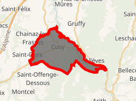
| |
 Cusy  Cusy | |
| Coordinates: 45°45′57″N 6°01′53″E | |
| Country | France |
| Region | Auvergne-Rhône-Alpes |
| Department | Haute-Savoie |
| Arrondissement | Annecy |
| Canton | Rumilly |
| Intercommunality | CA Grand Annecy |
| Government | |
| • Mayor (2014–2020) | Serge Petit |
| Area 1 | 17.43 km2 (6.73 sq mi) |
| Population (2017-01-01)[1] | 1,850 |
| • Density | 110/km2 (270/sq mi) |
| Demonym(s) | Cusiard / Cusiarde |
| Time zone | UTC+01:00 (CET) |
| • Summer (DST) | UTC+02:00 (CEST) |
| INSEE/Postal code | 74097 /74540 |
| Elevation | 420–1,365 m (1,378–4,478 ft) |
| 1 French Land Register data, which excludes lakes, ponds, glaciers > 1 km2 (0.386 sq mi or 247 acres) and river estuaries. | |
Geography

The Chéran forms the commune's north-eastern border.
gollark: Please stop spamming.
gollark: What?
gollark: There are probably lots.
gollark: Please note that "reality" does not offer saved game support or sandbox mode.
gollark: It's called "reality" and you can play it now!
References
- "Populations légales 2017". INSEE. Retrieved 6 January 2020.
| Wikimedia Commons has media related to Cusy. |
| Authority control |
|
|---|
This article is issued from Wikipedia. The text is licensed under Creative Commons - Attribution - Sharealike. Additional terms may apply for the media files.