Curlwaa, New South Wales
Curlwaa is a locality in New South Wales, Australia.
| Curlwaa New South Wales | |
|---|---|
 | |
Curlwaa | |
| Coordinates | 34°06′S 141°58′E |
| Population | 405 (2006 census)[1] |
| Postcode(s) | 2648 |
| Location | 4 km (2 mi) east of Wentworth |
| LGA(s) | Wentworth Shire |
| State electorate(s) | Murray |
| Federal Division(s) | Farrer |
Curlwaa is an irrigation settlement a few kilometres upstream of Wentworth on the Murray River in far southwestern New South Wales. It is the first Government irrigation scheme in New South Wales, established in 1890.
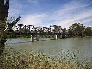
Abbotsford Bridge
The Abbotsford Bridge spans the Murray River between Yelta, Victoria and Curlwaa, New South Wales. The name, Abbotsford, is derived from the punt service that previously operated at the site of the bridge. This was known as Abbot's Ford. Over time, this area of the river northwest of Merbein became known as Abbotsford.
The bridge was opened on 10 July 1928 by the Admiral Sir Dudley de Chair KCB KBE MVO, Governor of New South Wales.
gollark: minoteaur is just plain RPC - you do `POST /rpc` with a function and its arguments as JSON.
gollark: You're forced to try and map the data/functions your thing provides onto a structure which may not really fit them well.
gollark: To be honest I find REST kind of an uncool way to design APIs.
gollark: The backend doesn't actually do much, since it actually uses a really simple RPC thing I put together, so it didn't take that long.
gollark: Also I rewrote the minoteaur backend to use a trendier web framework, *THIS WILL NEVER BE FINISHED*.
References
- Australian Bureau of Statistics (25 October 2007). "Curlwaa (Suburb)". 2006 Census QuickStats. Retrieved 9 October 2008.
This article is issued from Wikipedia. The text is licensed under Creative Commons - Attribution - Sharealike. Additional terms may apply for the media files.