County Borough of Teesside
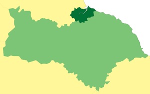
Teesside was, from 1968 to 1974, a local government district in northern England. It comprised a conurbation that spanned both sides of the River Tees from which it took its name. The district had the status of a county borough and was independent of the county councils of the North Riding of Yorkshire,[2][3] and Durham. The entirety of Teesside was represented by the Lord lieutenant of the North Riding, even those areas north of the Tees in Durham.
| Teesside | |
|---|---|
 Teesside within the North Riding | |
| Population | |
| • 1971 | 396,233[1] |
| History | |
| • Created | 1968 |
| • Abolished | 1974 |
| • Succeeded by | Cleveland |
| Status | County borough Civil parish |
| Government | |
| • HQ | Middlesbrough |
| • Motto | Progress in Unity |
 Coat of arms | |
Predecessor authorities
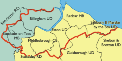
The River Tees formed the historic county boundary between Yorkshire and Durham. A continuous conurbation had built up around the mouth of the river, increasing greatly in population from the nineteenth century as the industrial potential of the area was developed.[3]
| County | District | Created | Changes |
|---|---|---|---|
| Durham | Billingham UD | 1923 (Previously a parish in Stockton Rural District) | Enlarged in 1937 |
| Stockton-on-Tees MB | Reformed by Municipal Corporations Act 1835 | Until 1889 partly in Yorkshire: in that year the county boundary was altered so that the entire borough was in County Durham | |
| North Riding of Yorkshire | Eston LGD | Formed under Local Government Act 1858 in 1884 | Became Eston UD in 1894, absorbed South Bank in Normanby UD 1915 |
| Middlesbrough MB | Incorporated by charter of 1853 | Enlarged 1866, 1887. Became a county borough in 1889. Extended 1913 (absorbed Ormesby), 1929, 1932 | |
| Ormesby LGD | Formed under Local Government Act 1858 in 1865 | Became Ormesby UD, abolished 1913: most absorbed by Middlesbrough CB, part to Middlesbrough RD | |
| Redcar LGD | Formed under Local Government Act 1858 in 1885 | Became UD in 1894, incorporated as MB in 1922 | |
| South Bank in Normanby LGD | Formed under Local Government Act 1858 in 1865 | Renamed Normanby LGD 1888, became an UD in 1894, absorbed by Eston UD 1915 | |
| South Stockton LGD | Formed under Local Government Act 1858 in 1863 | Incorporated as Thornaby on Tees MB 1892 |
LGD = Local Government District MB = Municipal Borough, CB = County Borough, UD = Urban District
Formation
Local Government Commission for England
Under the Local Government Act 1958 a Local Government Commission for England was established to review administrative structures throughout the country.

The commission published draft proposals for the North Eastern General Review Area in April 1962 and a final report in October 1963.[4] The report recommended the creation of a single county borough for the Teesside area as it:
...seemed to us necessary to ensure that the pattern of local government was such as to make the planning of development and the organisation of services fully effective, and to make certain that new development, such as houses, main roads, bridges and shops would match the growth and location of industry instead of perpetuating the patterns of the past. We were impressed by the need on Tees-side for more housing to relieve overcrowding, to replace outworn properties, and to meet the increase in population due to industrial expansion. Yet unless Teesside could be planned as a whole, it seemed to us impossible to ensure that new houses would be built in places most convenient for the people who would live in them, as it was difficult for the present ten separate housing authorities, each with their own housing list, to do other than build within or near their own boundaries...
With the southern moorland, the coast and the river, Tees-side has a splendid setting and it ought to be made worthy of its 400,000 inhabitants. This task requires a comprehensive plan for the whole area designed to secure the benefit of its port, its industries and its commerce, the reclamation of its marshlands, the building of new roads and bridges, the renewal of obsolete parts of the old riverside development, the designing of new centres and the provision of new amenities. This formidable task gives scope not for ten authorities to develop or redevelop ten towns but for a single authority to work out the details of the probable future growth and needs of Tees-side, and then prepare and carry out a single plan for the whole area.[5]
Reaction
Reaction to the proposals was divided. The councils of Middlesbrough, Stockton, Thornaby, Redcar and Saltburn & Marske warmly welcomed the report. The two other towns due to be amalgamated, Billingham and Eston, were opposed.[4]
The two county councils of Durham and Yorkshire, North Riding, completely rejected the commission's report. The chairman of Durham County Council, whose county was also to lose areas to the county boroughs of Hartlepool and Sunderland, described it as "the biggest menace to the north-east since the war". Sir Timothy Kitson, Member of Parliament for the Yorkshire constituency of Richmond, set out the losses to the North Riding: the administrative county was to lose about 25% of its population (reduced from about 428,000 to 318,000), and about 40% of its rateable value (down from £15.8 to £9.3 million).[5] The chairman of North Riding County Council believed the proposals to be detrimental to the majority of the inhabitants of the administrative county.[4]
The Teesside Order 1967
The recommendations were accepted, with boundary adjustments, by the Government in October 1965. The main changes were to exclude most of Saltburn & Marske, and the extension of the boundary of the county borough southwards. Part of Preston-on-Tees was added to include Preston Hall, an art gallery and museum owned by Stockton Corporation within the county borough.[5]
In January 1967, Anthony Greenwood, Minister of Housing and Local Government, made the Teesside Order 1967 to carry the recommendations into effect. The new borough of Teesside was to combine the areas of:[3][5]
| Abolished† or reduced‡ district | Area | Notes |
|---|---|---|
| County Borough of Middlesbrough† | 2,886 acres (11.68 km2) | |
| Municipal Borough of Redcar† (most) | 2,089 acres (8.45 km2) | Remaining 1 acre (0.0040 km2) passed to Saltburn & Marske by the Sea UD |
| Municipal Borough of Stockton-on-Tees† | 2,423 acres (9.81 km2) | |
| Municipal Borough of Thornaby-on-Tees† | 779 acres (3.15 km2) | |
| Billingham Urban District† | 2,934 acres (11.87 km2) | Remaining 245 acres (0.99 km2) passed to Stockton RD |
| Eston Urban District† (most) | 1,873 acres (7.58 km2) | Remaining 218 acres (0.88 km2) passed to Guisborough UD |
| Guisborough Urban district‡ (part) | 1,236 acres (5.00 km2) | |
| Saltburn and Marske by the Sea Urban District‡ (small part) | 12 acres (0.049 km2) | |
| Stockton Rural District‡ (part) | 895 acres (3.62 km2) | Parts of the parishes of Carlton, Elton, Grindon, Norton, Preston-on-Tees |
| Stokesley Rural District‡ (part) | 2,600 acres (11 km2) | Parishes of Hemlington and Marton, parts of the parishes of Maltby, Newby, Nunthorpe, Ormesby and Stainton |
Following its passing by both Houses of Parliament, the order came into effect, with the first election to the new borough council taking place in May 1967, serving as a shadow authority until it came into its full powers on 1 April 1968.[5]
Inauguration
In a ceremony held at Middlesbrough Town Hall, the charter of the new borough was presented by Lord Normanby, the Lord Lieutenant of the North Riding of Yorkshire. Sir William Crosthwaite, who had served as Middlesbrough's mayor on five occasions, presented a new gold ceremonial mace to the corporation. The maces of the former boroughs of Middlesbrough, Stockton, Redcar and Thornaby along with the orders of constitution of the urban district councils of Eston and Billingham were handed over to the new authority for safekeeping.[6]
Borough council
The county borough was divided into twenty-six wards, each represented by three councillors and one alderman, so that the council had a total membership of 104: 78 councillors and 26 aldermen.
The wards were:
|
|
|
The first election was held in May 1967 with the council forming a "shadow authority" until April 1968. Annual elections were then held, with one third of the councillors retiring each year. Aldermen had a six-year term of office, with half being elected by the council every three years.
| Year | Conservative | Labour | Independent and Citizen's Party |
CONTROL |
|---|---|---|---|---|
| 1967 | 56 | 39 | 9 | Conservative |
| 1968[7] | 61 | 34 | 9 | |
| 1969[8] | 65 | 30 | 9 | |
| 1970[9] | 63 | 33 | 5 | |
| 1971[10] | 53 | 46 | 5 | |
| 1972[11] | 44 | 57 | 3 | Labour |
Coat of arms
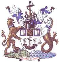
The county borough corporation was granted armorial bearings by the College of Arms on 26 March 1968. the arms were blazoned as follows:[12]
Argent an ancient ship sails furled pennons flying Sable, on a chief Azure on a pale Sable fimbriated and between two crucibles Argent a basilisk Or.
Crest: On a wreath Argent and Azure on a grassy mount Proper an anchor Or between two cogwheels Sable.
Supporters: On the dexter side a lion Or resting the interior hind paw on three ingots of steel Proper and on the sinister side a seahorse Argent scales, dorsal fin and tail Or, each collared Azure thereon a barrulet wavy Argent .The whole upon a compartment per pale of a grassy mount and waves of the sea Proper.
Badge: A tau cross Azure enfiled by a mural crown Or.
The ship on the shield and the anchor in the crest depicted trade and shipbuilding. The crucibles stood for the iron and steel industry. The basilisk, a fabulous creature whose gaze could turn people to stone, represented the chemical industry. The narrow silver fimbriations on either side of the basilisk were intended to represent the rails of the Stockton and Darlington Railway, the world's first passenger railway, that lay partly in the borough. The engineering industry was represented by the cogwheels in the crest. The supporters on either side of the arms were a lion for the land connections of the borough and a seahorse for the sea. Both supporters had blue collars bearing a silver wave for the River Tees.[13]
Teesside Municipal Transport

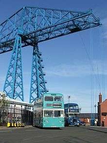
The county borough took over three public transport undertakings: Middlesbrough Corporation Transport, Stockton Corporation Transport (which also operated services on behalf of Thornaby Corporation) and the Tees-Side Railless Traction Board (TRTB). The TRTB had been formed by Eston and Middlesbrough councils in 1918, and was a pioneer operator of electric trolleybuses.[14]
The three undertakings adopted a common livery of turquoise and cream in 1967 in preparation for their amalgamation. On 1 April 1968 the combined fleet became Teesside Municipal Transport. Teesside initially operated a mixed fleet of trolleybuses and omnibuses, but on 4 April 1971 trolleybus operation ended. A formal closure ceremony was held two weeks later.[14]
Teesside Constabulary
Before 1968 the Teesside area was served by three police forces: Middlesbrough Borough Police, Durham Constabulary and the North Riding of Yorkshire Constabulary. It was originally envisaged that the new county borough would form a joint constabulary with the North Riding under the provisions of the Police Act 1964.[15] The amalgamation scheme was later modified, and under the Teesside (Amendment) Order 1968, the county borough formed its own Constabulary. The new force had a strength of approximately 725 officers, comprising the entire Middlesbrough force of 350, 200 from the North Riding Constabulary and 175 from the Durham force.[16]
Abolition
The county borough had a short existence of just six years. By the time the order creating the borough was passing through parliament, the Redcliffe-Maud Commission had been appointed to completely review local government structures in England and Wales. Opposition MP Graham Page attacked the government for creating county boroughs in Teesside and other areas such as the Hartlepools and Torbay before the commission reported:
"Do the Government consider that these piecemeal orders represent dynamic policy? Do they think that these Measures – one or two orders a week presented to Parliament during farcical morning sittings at which the honourable gentlemen opposite do not bother to turn up to support their Ministers represent dynamic local government policy?"[5]
Another round of local government reorganisation took place under the Local Government Act 1972, which introduced a uniform two-tier system of counties and districts. One of the new counties "Area No.4" was based on the Teesside conurbation. The county was eventually named Cleveland on the suggestion of several local authorities in the area.[17]
Originally it was intended that Teesside would continue as non-metropolitan district of Cleveland. Peter Walker, Secretary of State for the Environment stated in January 1972:
"It would be wholly wrong... to divide again the County Borough of Teesside... it has made all its investment in a county borough of that size, and it would be wholly wrong to tear it to pieces."
However, the boundaries of the proposed county of Cleveland were considerably altered, with a number of marginal areas removed. Under the revised scheme, the Teesside district would have 70 percent of the county's population, and it was felt that it would dominate the county. Accordingly, new guidelines were issued to the Local Boundaries Commission in March 1972 that was charged with drawing up district boundaries: Cleveland "should be divided into not less than four new districts with populations comparable as is reasonably practicable having regard in particular to the pattern of local government before the establishment of the Teesside county borough".[18]
The county borough was abolished on 1 April 1974, and its area was divided between three of the four districts of Cleveland. The fourth district was based on the County Borough of Hartlepool. Teesside was divided as follows:
| Wards of county borough | New district | Areas added |
|---|---|---|
| Coatham, Eston Grange, Kirkleatham, Ormesby, Redcar and South Bank | Langbaurgh | Guisborough, Loftus, Saltburn & Marske-by-the-Sea and Skelton & Brotton Urban Districts |
| Acklam, Ayresome, Berwick Hills, Gresham, Linthorpe, Marton, North Ormesby, St Hilda's, Thorntree, Tollesby | Middlesbrough | The parish of Nunthorpe from Stokesley Rural District |
| Billingham East, Billingham West, Grangefield, Hartburn, Mile House, North End, Norton, Stockton South, Thornaby East, Thornaby West | Stockton-on-Tees | Part of Stockton Rural District, parishes of Castlelevington, Hilton, Ingleby Barwick, Kirklevington, Maltby and Yarm from Stokesley Rural District |
References
- 1971 Census; Small Area Statistics
- Great Britain Historical GIS / University of Portsmouth, Teesside CB. Retrieved 17 September 2009.
-
- Youngs, Frederic A, Jr. (1991). Guide to the Local Administrative Units of England, Vol.2: Northern England. London: Royal Historical Society. pp. 661–667, 788–789. ISBN 0-86193-127-0.
- "Commission See Tees-Side As County Borough 12 Local Authorities into One". The Times. 21 November 1963. p. 8.
- "Local Government, Teesside". Hansard 1893 – 2005. Parliament of the United Kingdom. 14 February 1967. Retrieved 17 September 2009.
- "New Borough of Teesside". The Times. 2 April 1968. p. 3.
- "Tories reap harvest from Labour". The Times. 10 May 1968. p. 8.
- "Results in detail of the borough elections in Britain". The Times. 12 May 1969.
- "Borough votes give boost to Labour". The Times. 8 May 1970. p. 4.
- "Tories lose ground in face of Labour upsurge in local polls". The Times. 14 May 1971. p. 5.
- "Widespread Labour gains in borough elections". The Times. 5 May 1972.
- Briggs, Geoffrey (1971). Civic and Corporate Heraldry: A Dictionary of Impersonal Arms of England, Wales and N. Ireland. London: Heraldry Today. pp. 382–384. ISBN 0-900455-21-7.
- Brown, Thomas H (1973). Coats of Arms of Cleveland. Margate: Eyre & Spottiswoode. pp. 6–7.
- Witton, A M (1981). Buses of North-East England, 3rd edition. Msnchester: A M Witton. pp. 3–4. ISBN 0-86047-083-0.
- "70 police forces to be axed in mergers". The Times. 19 May 1966.
- "Police (Teesside)". Hansard 1803 – 2005. Parliament of the United Kingdom. 27 March 1968. Retrieved 19 September 2009.
- "No. 4 Local Government Area". Hansard 1803–2005. Parliament of the United Kingdom. 26 January 1972. Retrieved 19 September 2009.
- "Counties and Metropolitan Districts in England". Hansard 1803–2005. Parliament of the United Kingdom. 17 April 1972. Retrieved 19 September 2009.