Cluny
Cluny is a commune in the eastern French department of Saône-et-Loire, in the region of Bourgogne-Franche-Comté. It is 20 km (12 mi) northwest of Mâcon.
Cluny | |
|---|---|
 A general view of Cluny | |
 Coat of arms | |
Location of Cluny 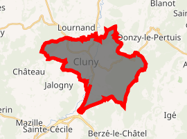
| |
 Cluny  Cluny | |
| Coordinates: 46°26′07″N 4°39′36″E | |
| Country | France |
| Region | Bourgogne-Franche-Comté |
| Department | Saône-et-Loire |
| Arrondissement | Mâcon |
| Canton | Cluny |
| Government | |
| • Mayor (2014–2020) | Henri Boniau |
| Area 1 | 23.71 km2 (9.15 sq mi) |
| Population (2017-01-01)[1] | 4,830 |
| • Density | 200/km2 (530/sq mi) |
| Time zone | UTC+01:00 (CET) |
| • Summer (DST) | UTC+02:00 (CEST) |
| INSEE/Postal code | 71137 /71250 |
| Elevation | 226–574 m (741–1,883 ft) (avg. 248 m or 814 ft) |
| 1 French Land Register data, which excludes lakes, ponds, glaciers > 1 km2 (0.386 sq mi or 247 acres) and river estuaries. | |
The town grew up around the Benedictine Abbey of Cluny, founded by Duke William I of Aquitaine in 910. The height of Cluniac influence was from the second half of the 10th century through the early 12th. The abbey was sacked by the Huguenots in 1562, and many of its valuable manuscripts were destroyed or removed.
Geography
The river Grosne flows northward through the commune and crosses the town.
gollark: It's quite hard to fit secured communications into the 4KB it gives you. Though my stuff always just pulled down extra code from the internet.
gollark: Oh, a fun thing you can do with killer drone swarms is hijack them to get your own killer drone swarm.
gollark: That exists? I would go for ArchLinuxARM personally, but eh.
gollark: Though they can hover out of reach or something.
gollark: Or scrench them. Just rightclick (shiftrightclick) with a scrench to remove them.
External links
| Wikimedia Commons has media related to Cluny (Saône-et-Loire). |
- Official website (in French)
- Paradoxplace – Cluny Page – Photos
| Authority control |
|
|---|
This article is issued from Wikipedia. The text is licensed under Creative Commons - Attribution - Sharealike. Additional terms may apply for the media files.