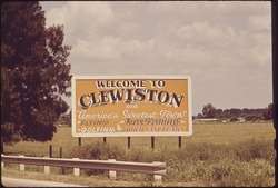
Clewiston, Florida
Clewiston is a city in Hendry County, Florida, United States. Its location is 80 miles (130 km) northwest of Fort Lauderdale on the Atlantic coastal plain. The population was 7,155 at the 2010 census,[5] up from 6,460 at the 2000 census. The estimated population in 2018 was 7,985.[6] The city is located on the south bank of Lake Okeechobee, and the Lake Okeechobee Scenic Trail (LOST) passes through the edge of the city. The city is home to Billie Swamp Safari, the Clewiston Museum and the Dixie Crystal Theatre. The area has been home to Seminole tribe members and sugar plantations, with the Ah-Tah-Thi-Ki Seminole Indian Museum located 32 miles (51 km) south of the city.
Clewiston, Florida | |
|---|---|
 | |
| Motto(s): America's Sweetest Town | |
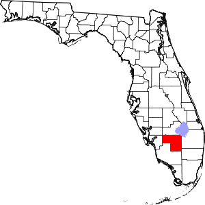
 Location in Hendry County and the state of Florida | |
| Coordinates: 26°45′N 80°56′W | |
| Country | |
| State | |
| County | Hendry |
| Settled | 1920 |
| Incorporated | 1925 |
| Area | |
| • Total | 4.51 sq mi (11.68 km2) |
| • Land | 4.50 sq mi (11.66 km2) |
| • Water | 0.01 sq mi (0.03 km2) |
| Elevation | 16 ft (5 m) |
| Population (2010) | |
| • Total | 7,155 |
| • Estimate (2019)[2] | 8,020 |
| • Density | 1,782.22/sq mi (688.08/km2) |
| Time zone | UTC-5 (Eastern (EST)) |
| • Summer (DST) | UTC-4 (EDT) |
| ZIP code | 33440 |
| Area code(s) | 863 |
| FIPS code | 12-13000[3] |
| GNIS feature ID | 0280572[4] |
| Website | www |
History


The area beside Lake Okeechobee was once used as a fishing camp by the Seminole tribe. The first permanent settlement began in 1920, when John O'Brien of Philadelphia and Alonzo Clewis of Tampa purchased a large tract of land to establish a town. They commissioned a town plan and built the Moore Haven & Clewiston Railway to connect the community to the Atlantic Coast Line Railroad at Moore Haven. Incorporated as a city in 1925, Clewiston would become noted for its sport fishing, particularly of largemouth bass.
Large sugar plantations were established around Lake Okeechobee. By the 1950s and 1960s, the cultivation of citrus, vegetables and cattle were also important to the economy. The US Sugar Corporation, however, remained the dominant manufacturer in Clewiston, which became known as "America's Sweetest Town". On June 24, 2008, Governor Charlie Crist announced that the state of Florida had arranged to buy for $1.75 billion the company's 187,000 acres (76,000 ha), including the refinery in Clewiston. On November 11, the plan was scaled back to $1.34 billion for 181,000 acres (73,000 ha) of farmland, no longer including the mill, citrus processing facilities and other assets. This would allow the company to remain in business and leave open the possibility of preserving its 1,700 jobs. Over the next seven crop cycles, the farmland would be leased back from the state to US Sugar for $60 million. It would then be converted into reservoirs and water-filtering areas as part of the ongoing restoration of the Everglades ecosystem.
Geography
Clewiston is located in the northeast corner of Hendry County at 26°45′12″N 80°56′01″W,[7] on the southwestern shore of Lake Okeechobee. It is part of the Florida Heartland region.
U.S. Route 27 passes through the center of Clewiston, leading west then north 15 miles (24 km) to Moore Haven, and southeast 16 miles (26 km) to South Bay. Florida State Road 80 runs with US 27 through Clewiston but leads west 31 miles (50 km) to LaBelle, the Hendry County seat.
According to the U.S. Census Bureau, Clewiston has a total area of 4.7 square miles (12.2 km2), of which 0.027 square miles (0.07 km2), or 0.54%, are water.[5]
Climate
| Climate data for Clewiston, Florida (1980-2010) | |||||||||||||
|---|---|---|---|---|---|---|---|---|---|---|---|---|---|
| Month | Jan | Feb | Mar | Apr | May | Jun | Jul | Aug | Sep | Oct | Nov | Dec | Year |
| Average high °F (°C) | 74.8 (23.8) |
77.4 (25.2) |
80.5 (26.9) |
84.6 (29.2) |
89.3 (31.8) |
91.1 (32.8) |
91.9 (33.3) |
92.0 (33.3) |
90.3 (32.4) |
86.8 (30.4) |
81.2 (27.3) |
76.3 (24.6) |
84.7 (29.3) |
| Average low °F (°C) | 50.3 (10.2) |
53.3 (11.8) |
56.1 (13.4) |
59.6 (15.3) |
65.7 (18.7) |
71.0 (21.7) |
72.3 (22.4) |
73.1 (22.8) |
72.5 (22.5) |
66.7 (19.3) |
59.8 (15.4) |
53.6 (12.0) |
62.8 (17.1) |
| Average precipitation inches (mm) | 1.9 (48) |
2.3 (58) |
3.2 (81) |
2.4 (61) |
3.6 (91) |
8.9 (230) |
8.1 (210) |
8.7 (220) |
7.2 (180) |
3.2 (81) |
2.0 (51) |
1.8 (46) |
53.3 (1,357) |
| Source: USA.com[8] | |||||||||||||
Demographics
| Historical population | |||
|---|---|---|---|
| Census | Pop. | %± | |
| 1940 | 1,338 | — | |
| 1950 | 2,499 | 86.8% | |
| 1960 | 3,114 | 24.6% | |
| 1970 | 3,896 | 25.1% | |
| 1980 | 5,219 | 34.0% | |
| 1990 | 6,085 | 16.6% | |
| 2000 | 6,460 | 6.2% | |
| 2010 | 7,155 | 10.8% | |
| Est. 2019 | 8,020 | [2] | 12.1% |
| U.S. Decennial Census[9] | |||
As of the census[3] of 2000, there were 6,460 people, 2,174 households, and 1,632 families residing in the city. The population density was 1,381.0 people per square mile (533.0/km2). There were 2,434 housing units at an average density of 520.3 per square mile (200.8/km2). The racial makeup of the city was 75.79% White, 10.93% African American, 0.39% Native American, 1.18% Asian, 9.64% from other races, and 2.07% from two or more races. Hispanic or Latino of any race were 40.94% of the population.
There were 2,174 households, out of which 39.5% had children under the age of 18 living with them, 55.9% were married couples living together, 12.5% had a female householder with no husband present, and 24.9% were non-families. 18.9% of all households were made up of individuals, and 7.2% had someone living alone who was 65 years of age or older. The average household size was 2.93 and the average family size was 3.32.
In the city, the population was spread out, with 29.7% under the age of 18, 10.3% from 18 to 24, 28.3% from 25 to 44, 20.8% from 45 to 64, and 10.9% who were 65 years of age or older. The median age was 32 years. For every 100 females, there were 103.9 males. For every 100 females age 18 and over, there were 104.4 males.
The median income for a household in the city was $37,143, and the median income for a family was $38,652. Males had a median income of $31,139 versus $21,049 for females. The per capita income for the city was $15,527. About 14.8% of families and 18.8% of the population were below the poverty line, including 25.9% of those under age 18 and 7.1% of those age 65 or over.
In 2010 Clewiston had a population of 7,155. The racial and ethnic makeup of the population was 48.7% Hispanic or Latino, 35.2% non-Hispanic white, 12.7% black or African American, 0.8% Native American, 0.7% Asian Indian, 1.6% other Asian, 0.2% non-Hispanic reporting some other race, and 2.9% reporting two or more races.[10]
Education
The following are public schools located in the area, operated by Hendry County Schools:
- Eastside Elementary
- Westside Elementary
- Central Elementary
- Clewiston Middle School
- Clewiston High School
- Clewiston Christian School
Libraries
The Hendry County Library Cooperative in Florida includes the Clewiston Library, Barron Library (located in LaBelle, the county seat) and the Harlem Library.
All three libraries provide Hendry County residents with materials and general information, and each library has a secondary individualized area of focus. The Clewiston Library has a Florida room to house historical reference material and books pertinent to local and state history. The Harlem Community Library is located in a former school building which also houses the Harlem Academy daycare center and its specialty is a growing African American collection. The Barron Library collects genealogical materials.
The Clewiston Library also recently sought and received an LSTA grant to digitize their local newspaper, The Clewiston News and have the digital versions added to the free, open access Florida Digital Newspaper Library.
Sites of interest
- Ah-Tah-Thi-Ki Seminole Indian Museum, 32 miles (51 km) south of Clewiston in the Big Cypress Indian Reservation
- Clewiston Inn
- Clewiston Museum
- Dixie Crystal Theatre
- Lake Okeechobee Scenic Trail (LOST)
- Tony's Mound
Notable people
- Randy Dixon, football player
- Eric Green, football player
- Alfonso Marshall, football player
- Roland Martin, professional fisherman
- Steffon Bradford, professional basketball player
- Quorey Payne, football player
See also
References
- "2019 U.S. Gazetteer Files". United States Census Bureau. Retrieved July 2, 2020.
- "Population and Housing Unit Estimates". United States Census Bureau. May 24, 2020. Retrieved May 27, 2020.
- "U.S. Census website". United States Census Bureau. Retrieved 2008-01-31.
- "US Board on Geographic Names". United States Geological Survey. 2007-10-25. Retrieved 2008-01-31.
- "Geographic Identifiers: 2010 Demographic Profile Data (G001): Clewiston city, Florida". American Factfinder. U.S. Census Bureau. Retrieved April 26, 2017.
- "Population and Housing Unit Estimates". Retrieved September 1, 2019.
- "US Gazetteer files: 2010, 2000, and 1990". United States Census Bureau. 2011-02-12. Retrieved 2011-04-23.
- "Climatological Information for Clewiston, FL", USA.com, 2003. Web: .
- "Census of Population and Housing". Census.gov. Retrieved June 4, 2015.
- 2010 general demographic chart from the US census for Clewiston
External links
| Wikimedia Commons has media related to Clewiston, Florida. |
