Church, Lancashire
Church is a large village in Hyndburn, Lancashire, England, situated a mile west of Accrington. The village has a population of 5,186 at the 2011 Census, an increase from 3,990 according to the 2001 census.[lower-alpha 1][2][1]
| Church | |
|---|---|
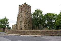 St James' Church, Church Kirk | |
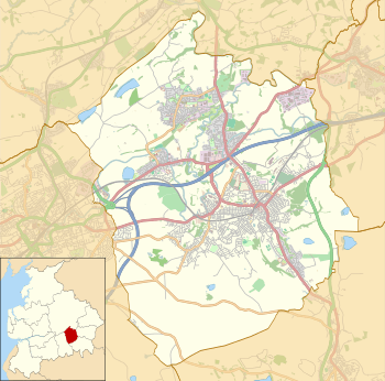 Church Shown within Hyndburn 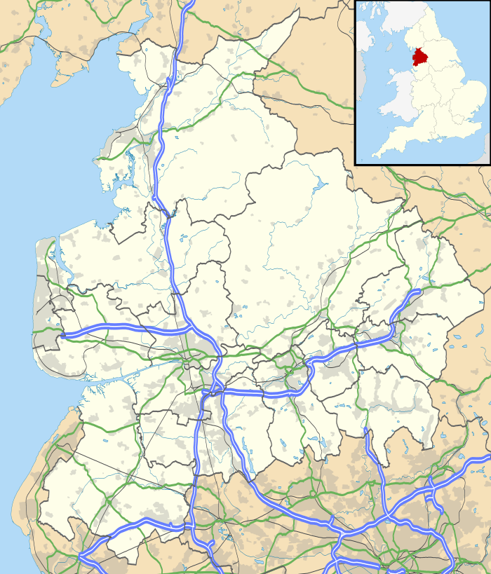 Church Location within Lancashire | |
| Area | 0.51 sq mi (1.3 km2) [1] |
| Population | 5,186 (2011) [1] |
| • Density | 10,169/sq mi (3,926/km2) |
| OS grid reference | SD746288 |
| • London | 231 miles (372 km) |
| District | |
| Shire county | |
| Region | |
| Country | England |
| Sovereign state | United Kingdom |
| Post town | ACCRINGTON |
| Postcode district | BB5 |
| Dialling code | 01254 |
| Police | Lancashire |
| Fire | Lancashire |
| Ambulance | North West |
| UK Parliament | |
| Website | www.hyndburnbc.gov.uk/ |
History and geography
Church was once a township in the ancient parish of Whalley, covering Oswaldtwistle Moor in the south and with Hyndburn Brook forming the boundary with Rishton as far as Dunkenhalgh in Clayton-le-Moors and past Dill Hall toward Whalley Road. This became a civil parish in 1866.[3]
The parish church is the medieval Church of St James. The tower dates to the late medieval era, and was damaged by a fire in 1983. The nave was constructed in 1805. Edward Ormerod or Ormrod (1834-1894) was born in the village of Church. He was the inventor in 1867 of the patent Ormerod Butterfly Clip, which has been responsible for saving the lives of generations of coal miners.
The main road running through the village is the A679. The local travel links are located less than a mile from the village centre to Church and Oswaldtwistle railway station and 27 miles (43 km) to Blackpool Airport. Church is the halfway point on the Leeds and Liverpool Canal.
Governance
Prior to 1894 Church had a civil parish, and between 1894 and 1974 the area was administered by an Urban District.[4] It has since become an unparished part of the borough of Hyndburn.
Economy and amenities
Church is a large village with a wealth of amenities, including a supermarket, bakery, bookmaker, sports centre, a fire station and a car sales garage. Another car sales garage was closed down and demolished in 2015, making way for a restaurant.[5] A small library was also once located in the village, but closed in 2006.
Education
Church is home to St Christopher's Church of England High School and St. Nicholas C.E. Primary School.
References
Notes
- The area in 2011 was listed as 132.5 hectares (0.51 sq mi).
Citations
- UK Census (2011). "Local Area Report – Church Built-up area (1119883746)". Nomis. Office for National Statistics. Retrieved 8 February 2018.
- Lancashire Profile Archived 8 August 2007 at the Wayback Machine lancashire.gov.uk
- "Church Tn/CP through time". visionofbritain.org.uk. GB Historical GIS / University of Portsmouth. Retrieved 31 August 2015.
- "Church UD through time". visionofbritain.org.uk. GB Historical GIS / University of Portsmouth. Retrieved 31 August 2015.
- MacPherson, Jon (24 April 2015). "New 'Brickworks' pub and restaurant will create 45 jobs". Accrington Observer. Retrieved 12 June 2015.
External links
| Wikimedia Commons has media related to Church, Lancashire. |
- The Leeds Liverpool Canal in Church www.towpathtreks.co.uk