Chinese Camp, California
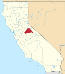
Chinese Camp is a census-designated place (CDP) in Tuolumne County, California, United States. The population was 126 at the 2010 census, down from 146 at the 2000 census. It lies in the grassy foothills of the Sierra Nevada near the southern end of California's Gold Country.
Chinese Camp | |
|---|---|
 Main Street, Chinese Camp | |
 Location in Tuolumne County and the state of California | |
 Chinese Camp Location in the United States | |
| Coordinates: 37°52′13″N 120°26′1″W | |
| Country | |
| State | |
| County | Tuolumne |
| Area | |
| • Total | 0.901 sq mi (2.332 km2) |
| • Land | 0.898 sq mi (2.326 km2) |
| • Water | 0.003 sq mi (0.007 km2) 0.28% |
| Elevation | 1,273 ft (388 m) |
| Population (2000) | |
| • Total | 126 |
| • Density | 140/sq mi (54/km2) |
| Time zone | UTC−08:00 (Pacific (PST)) |
| • Summer (DST) | UTC−07:00 (PDT) |
| ZIP Code | 95309 |
| Area code(s) | 209 |
| FIPS code | 06-13182 |
| GNIS feature ID | 233668 |
| Reference no. | 423[2] |

Geography
Chinese Camp is located at 37°52′13″N 120°26′1″W (37.870294, −120.433526).[3]
According to the United States Census Bureau, the CDP has a total area of 0.9 square miles (2.3 km2), 99.72% of it land and 0.28% of it water.
Natural history
Wilderness near Chinese Camp is the location of the last remaining known population of the federally listed threatened plant species Brodiaea pallida, the Chinese Camp brodiaea.[4]
History
Chinese Camp is the remnant of a notable California Gold Rush mining town. The settlement was first known as "Camp Washington" or "Washingtonville" and one of the few remaining streets is Washington Street. Some of the very first Chinese laborers arriving in California in 1849 were driven from neighboring Camp Salvado and resettled here, and the area started to become known as "Chinee" or "Chinese Camp" or "Chinese Diggings". At one point, the town was home to an estimated 5,000 Chinese.

The Chinese Camp post office was established in the general store on April 18, 1854. This building is currently vacant, and a post office is in operation on a plot of land rented from a local resident.
An 1892 Tuolumne County history indicates that, in 1856, four of the six Chinese companies (protective associations) had agents here and that the first tong war (between the Sam Yap and Yan Woo tongs) was fought near here when the population of the area totaled several thousand. The actual location is several miles away, past the 'red hills', near the junction of Red Hills Road and J-59.
An 1860 diary says Chinese Camp was the metropolis for the mining district, with many urban comforts. While placer mining had played out in much of the Gold Country by the early 1860s, it was still active here as late as 1870. An 1899 mining bulletin listed the total gold production of the area as near US$2.5 million.

Chinese Camp is the location and subject of California Historical Landmark 423 – The Saint Francis Xavier Roman Catholic Church, established in 1849, making it the oldest church in the county. The church was renovated in 1949 by John Nicolini but has since fallen into disrepair. The church itself is owned by the Stockton archdiocese.
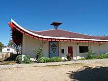
The current Chinese Camp School is very distinctive, having been designed by Dolores Nicolini in the style of a Chinese pagoda. This school has been in operation since 1970. Previously, the school was in a building near the church. This building was lost in a fire on May 4, 2006. The fire was caused by carelessness on the part of several local individuals.
Demographics
| Historical population | |||
|---|---|---|---|
| Census | Pop. | %± | |
| U.S. Decennial Census[5] | |||
2010
At the 2010 census Chinese Camp had a population of 126. The population density was 139.9 people per square mile (54.0/km2). The racial makeup of Chinese Camp was 92 (73%) White, 0 African American, 7 (6%) Native American, 0 Asian, 0 Pacific Islander, 16 (13%) from other races, and 11 (9%) from two or more races. Hispanic or Latino of any race were 25 people (20%).[6]
The whole population lived in households, no one lived in non-institutionalized group quarters and no one was institutionalized. 0 lived in non-institutionalized group quarters, and 0 were institutionalized.
There were 50 households, 15 (30%) had children under the age of 18 living in them, 23 (46%) were opposite-sex married couples living together, 2 (4%) had a female householder with no husband present, 6 (12%) had a male householder with no wife present. There were 5 (10%) unmarried opposite-sex partnerships, and 1 (2%) same-sex married couples or partnerships. 15 households (30%) were one person and 6 (12%) had someone living alone who was 65 or older. The average household size was 2.5. There were 31 families (62% of households); the average family size was 3.2.
The age distribution was 30 people (24%) under the age of 18, 11 people (9%) aged 18 to 24, 24 people (19%) aged 25 to 44, 46 people (37%) aged 45 to 64, and 15 people (12%) who were 65 or older. The median age was 43.5 years. For every 100 females, there were 106.6 males. For every 100 females age 18 and over, there were 108.7 males.
There were 60 housing units at an average density of 66.6 per square mile, of the occupied units 36 (72.0%) were owner-occupied and 14 (28.0%) were rented. The homeowner vacancy rate was 3%; the rental vacancy rate was 0%. 99 people (79% of the population) lived in owner-occupied housing units and 27 people (21%) lived in rental housing units.
2000
At the 2000 census there were 146 people, 57 households, and 38 families in the CDP. The population density was 162.5 people per square mile (62.6/km2). There were 64 housing units at an average density of 71.2 per square mile (27.5/km2). The racial makeup of the CDP was 92% White, 1% African American, 3% Native American, 1% Asian, 1% from other races, and 2% from two or more races. Hispanic or Latino of any race were 12%.[7]
Of the 57 households 32% had children under the age of 18 living with them, 54% were married couples living together, 12% had a female householder with no husband present, and 32% were non-families. 30% of households were one person and 9% were one person aged 65 or older. The average household size was 2.6 and the average family size was 3.2.
The age distribution was 28% under the age of 18, 10% from 18 to 24, 32% from 25 to 44, 20% from 45 to 64, and 10% 65 or older. The median age was 35 years. For every 100 females, there were 117.9 males. For every 100 females age 18 and over, there were 110.0 males.
The median household income was $31,875 and the median family income was $35,833. Males had a median income of $25,833 versus $18,750 for females. The per capita income for the CDP was $11,501. There were 21% of families and 23% of the population living below the poverty line, including 36% of under eighteens and 14% of those over 64.
Government
In the California State Legislature, Chinese Camp is in the 8th Senate District, represented by Republican Andreas Borgeas, and the 5th Assembly District, represented by Republican Frank Bigelow.[8]
In the United States House of Representatives, Chinese Camp is in California's 4th congressional district, represented by Republican Tom McClintock.[9]
References
- "2010 Census Gazetteer Files – Places – California". United States Census Bureau. Retrieved March 26, 2015.
- "Chinese Camp". Office of Historic Preservation, California State Parks. Retrieved 2012-10-18.
- "US Gazetteer files: 2010, 2000, and 1990". United States Census Bureau. 2011-02-12. Retrieved 2011-04-23.
- Flora of North America
- "Census of Population and Housing". Census.gov. Retrieved June 4, 2016.
- "2010 Census Interactive Population Search: CA – Chinese Camp CDP". U.S. Census Bureau. Archived from the original on July 15, 2014. Retrieved July 12, 2014.
- "U.S. Census website". United States Census Bureau. Retrieved 2008-01-31.
- "Statewide Database". Regents of the University of California. Archived from the original on February 1, 2015. Retrieved March 26, 2015.
- "California's 4th Congressional District - Representatives & District Map". Civic Impulse, LLC. Retrieved September 28, 2014.
- Gudde, Erwin G. (1975). California Gold Camps. University of California Press. ISBN 0-520-02572-5.
External links
| Wikimedia Commons has media related to Chinese Camp, California. |
- Photographic virtual tour of Chinese Camp.
- Note: Although interesting, many of the descriptions are inaccurate and several prominent landmarks are omitted.
- Western Ghost Towns
- Chinese Camp history
