Channel Light Vessel Automatic
Channel Light Vessel Automatic is the name of a lightvessel in the English Channel. It is one of the 22 coastal weather stations whose conditions are automatically reported in the BBC Shipping Forecast. The vessel's position is 49°55′N 2°54′W, approximately 56 km (35 mi) north-northwest of Guernsey.
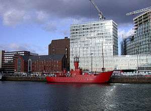 Channel lightvessel 23 at Canning Dock | |
| History | |
|---|---|
| Operator: | Trinity House |
| In service: | 25 November 2006 |
| Status: | Active as of 2020 |
| General characteristics | |
| Type: | Lightvessel |
| |
 | |
| |
| Coordinates | 49°54.459′N 2°53.744′W |
|---|---|
| Focal height | 12 m (39 ft) |
| Range | 15 mi (24 km) |
| Characteristic | F0.3 15s |
| Fog signal | 1 blast of 2 seconds every 20 seconds |
| Managing agent | Trinity House |
The lightvessel marks the western end of the English Channel Traffic Separation Zone.[1]
Signals
The light, on a 12 m (39 ft) tower, has a range of about 15 miles, and flashes for .3 seconds every 15 seconds. The fog signal gives a single 2 second blast every 20 seconds. The agile radio beacon transmits the letter "O" in morse code on X band and S band frequencies for nine seconds every thirty seconds.[2]
gollark: That version doesn't seem to have any sort of incentive mechanisms in it.
gollark: Nobody can agree on what communism means.
gollark: Communism is poorly defined too.
gollark: Star Trek doesn't have much of a coherent or sane economic system.
gollark: I said "not".
References
- "Channel Lightvessel". Trinity House. Retrieved 18 April 2016.
- "NOTICE TO MARINERS No.66/06". Trinity House. 30 October 2006. Archived from the original on 26 April 2011. Retrieved 19 June 2012.
External links
Surviving ships launched from 1919 to 1970 | |||||||
|---|---|---|---|---|---|---|---|
operational⛵ preserved⚓ | |||||||
| Merchant ships | |||||||
| Military ships |
| ||||||
This article is issued from Wikipedia. The text is licensed under Creative Commons - Attribution - Sharealike. Additional terms may apply for the media files.