Cemoro Lawang
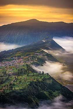
Cemoro Lawang (also known as Cemorolawang, Cemora Lawang or Cemara Lawang) is a very small hamlet north-east of Mount Bromo (East Java), Indonesia with the altitude of 2,217 meters above sea level. Administratively, this hamlet is a part of Ngadisari Village, Sukapura, Probolinggo Regency. Cemoro Lawang is one of many routes point to Tengger Caldera from Probolinggo route. There is a view point to see Mount Batok and Mount Bromo. It is principally a base for early morning climbs of Mt Bromo, an active volcano which stands in the middle of a Sand Sea. Many visitors approach the mountain from Surabaya which is about three hours drive away; others come from Bali.[1]
Cemoro Lawang | |
|---|---|
Dusun | |
 Cemoro Lawang at early morning | |
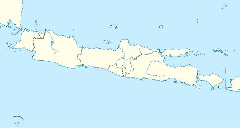
 Cemoro Lawang Location of Cemoro Lawang  Cemoro Lawang Cemoro Lawang (Indonesia) | |
| Coordinates: 7°55′22″S 112°57′52″E | |
| Country | |
| Region | Java |
| Province | |
| Regency | Probolinggo Regency |
| District | Sukapura |
| Subdistrict | Ngadisari |
| Elevation | 2,217 m (7,274 ft) |
| Time zone | UTC+7 (WIB) |
| Website | bromotenggersemeru |
Geography
Climate
Cemoro Lawang's climate is warm and temperate, and is classified as subtropical highland (Cwb) under the Köppen climate classification. The relatively brief wet season (also known as "summer") occurs at December to March, and is known to have lukewarm temperatures, shorter diurnal ranges, and a good deal of rainfall. The dry season stands out for the remainder of the year (June-September), and is best known for its chilly mornings, incidences of frost, and single-digit temperatures. The average temperature here is 13.2 °C, and the average rainfall is 1924 mm.
.jpg)
| Climate data for Cemoro Lawang, Bromo Tengger Semeru National Park (elevation 2,217 m or 7,274 ft) | |||||||||||||
|---|---|---|---|---|---|---|---|---|---|---|---|---|---|
| Month | Jan | Feb | Mar | Apr | May | Jun | Jul | Aug | Sep | Oct | Nov | Dec | Year |
| Average high °C (°F) | 17.3 (63.1) |
17.5 (63.5) |
17.6 (63.7) |
17.4 (63.3) |
17.4 (63.3) |
17 (63) |
16.3 (61.3) |
16.5 (61.7) |
17.1 (62.8) |
17.7 (63.9) |
17.5 (63.5) |
17.3 (63.1) |
17.2 (63.0) |
| Daily mean °C (°F) | 13.6 (56.5) |
13.7 (56.7) |
13.9 (57.0) |
13.5 (56.3) |
13.3 (55.9) |
12.8 (55.0) |
11.8 (53.2) |
12 (54) |
12.5 (54.5) |
13.3 (55.9) |
13.9 (57.0) |
13.6 (56.5) |
13.2 (55.7) |
| Average low °C (°F) | 9.9 (49.8) |
9.9 (49.8) |
10.3 (50.5) |
9.7 (49.5) |
9.3 (48.7) |
8.6 (47.5) |
7.4 (45.3) |
7.5 (45.5) |
8 (46) |
9 (48) |
10.3 (50.5) |
10 (50) |
9.2 (48.4) |
| Average precipitation mm (inches) | 297 (11.7) |
334 (13.1) |
348 (13.7) |
181 (7.1) |
104 (4.1) |
63 (2.5) |
33 (1.3) |
15 (0.6) |
19 (0.7) |
70 (2.8) |
145 (5.7) |
315 (12.4) |
1,924 (75.7) |
| Source: Climate-Data.org (temp & precip)[2] | |||||||||||||
Gallery
 Bromo Tengger Semeru National Park gate in Cemoro Lawang
 Cemoro Lawang fog
 Cemoro Lawang sub-alpine forest
References
- "How to Get to Bromo Independently - No Tour Needed". ASocialNomad. 2015-08-26. Retrieved 2018-12-18.
- "Climate: Cemoro Lawang". Climate-Data.org. Retrieved 18 December 2018.
External links
- Bromo Tengger Semeru official website (in Indonesian)
| Wikimedia Commons has media related to Cemoro Lawang. |
| Wikimedia Commons has media related to Mount Bromo. |
| Wikivoyage has a travel guide for Bromo-Tengger-Semeru National Park. |