California Historical Landmarks in Santa Barbara County, California
List table of the properties and districts — listed on the California Historical Landmarks — within Santa Barbara County, California.
- Note: Click the "Map of all coordinates" link to the right to view a Google map of all properties and districts with latitude and longitude coordinates in the table below.
Listings
width = 8% class="unsortable" style="background-color:
|
style="background-color:
|
width = 18% style="background-color:
|
style="background-color:
|
City or town | style="background-color:
|
|---|---|---|---|---|---|
 Burton Mound |
style="background-color:
|
Burton Mound | 129 W. Mason St. at Burton Circle 34°24′40″N 119°41′32″W |
Santa Barbara | A second plaque is at 1000 Carpinteria Ave. |
style="background-color:
|
Carpinteria and Indian Village of Mishopshnow | Carpinteria Valley Museum of History, 950 Maple Ave 34°23′33″N 119°30′39″W |
Carpinteria | ||
 Carrillo Adobe |
style="background-color:
|
Carrillo Adobe | 11 E Carrillo St. 34°25′19″N 119°42′06″W |
Santa Barbara | Also on the NRHP list as NPS-86000778 |
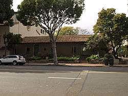
 Casa de la Guerra |
style="background-color:
|
Casa de la Guerra | 808-818 State St., 813-819 Anacapa St., and 9-25 E. de la Guerra St. 34°25′13″N 119°41′57″W |
Santa Barbara | Also on the NRHP list as NPS-77000346 |
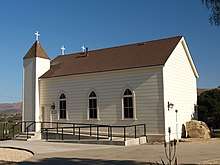 Chapel of San Ramon |
style="background-color:
|
Chapel of San Ramon | Tepusquet and Foxen Canyon Rds. 34°50′52″N 120°14′27″W |
Santa Maria | |
 Covarrubias Adobe |
style="background-color:
|
Covarrubias Adobe | 715 N Santa Barbara St. 34°25′16″N 119°41′48″W |
Santa Barbara | |
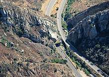 Gaviota Pass |
style="background-color:
|
Gaviota Pass | U.S. Route 101 34°29′07″N 120°13′43″W |
Goleta | |
style="background-color:
|
Hastings Adobe | 412 W Montecito St. |
Santa Barbara | ||
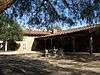
 Mission La Purisima Concepción |
style="background-color:
|
Mission La Purisima Concepción | La Purisima Mission State Historic Park 34°40′14″N 120°25′15″W |
Lompoc | Also on the NRHP list as NPS-70000147 |
 Lobero Theatre |
style="background-color:
|
Lobero Theatre | 33 E Canon Perdido St. 34°25′18″N 119°42′00″W |
Santa Barbara | |
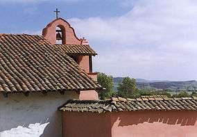
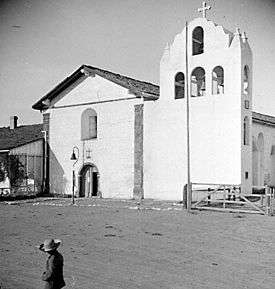
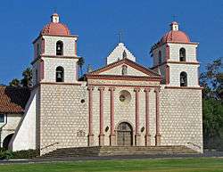 Mission Santa Barbara |
style="background-color:
|
Mission Santa Barbara | 2201 Laguna St. 34°26′18″N 119°42′50″W |
Santa Barbara | Also on the NRHP list as NPS-66000237 |
 Mission Santa Inés |
style="background-color:
|
Mission Santa Inés | 1760 Mission Dr. 34°35′40″N 120°08′12″W |
Solvang | |
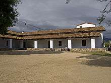
 Presidio of Santa Barbara |
style="background-color:
|
Presidio of Santa Barbara | El Presidio de Santa Barbara State Historic Park 34°25′21″N 119°41′50″W |
Santa Barbara | Also on the NRHP list as NPS-73000455 |
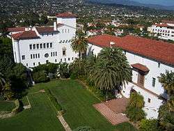 Santa Barbara County Courthouse |
style="background-color:
|
Santa Barbara County Courthouse | 1100 Anacapa St. 34°25′28″N 119°42′09″W |
Santa Barbara | Also on the NRHP list as NPS-81000177 |
style="background-color:
|
Site of original mission and remaining ruins of Mission La Purisima | 5085 'T' St. |
Lompoc | This address no longer exists | |
style="background-color:
|
Well, Hill 4 | Unocal Corporation, Mission Hills District |
Lompoc |
gollark: If you can't discuss things like that without interpreting it as toxic or a personal attack or something, 🐝 you somewhat.
gollark: I don't see how that is "necessarily toxic".
gollark: I suspect that it's because we discuss a wide range of stuff, which is an effect a hypothetical ControversialEsolangs would lack.
gollark: It hasn't, though.
gollark: Lots of things are Discord servers.
See also
References
| Wikimedia Commons has media related to California Historical Landmarks in Santa Barbara County, California. |
- "California Historical Landmarks By County". Ohp.parks.ca.gov. Retrieved 2019-04-03.
This article is issued from Wikipedia. The text is licensed under Creative Commons - Attribution - Sharealike. Additional terms may apply for the media files.