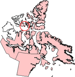
Byam Martin Island
Byam Martin Island (BEI-uhm) is one of the Canadian arctic islands located on the northern side of the Viscount Melville Sound in the territory of Nunavut. It is separated from the eastern coast of Melville Island, 27 km (17 mi) to the west, by the Byam Martin Channel; and from Bathurst Island, 35 km (22 mi) to the northeast, by the Austin Channel.[1]
 Byam Martin Island, Nunavut | |
| Geography | |
|---|---|
| Location | Northern Canada |
| Coordinates | 75°12′N 104°17′W |
| Archipelago | Queen Elizabeth Islands Canadian Arctic Archipelago |
| Area | 1,150 km2 (440 sq mi) |
| Length | 46 km (28.6 mi) |
| Width | 37 km (23 mi) |
| Highest elevation | 153 m (502 ft) |
| Administration | |
Canada | |
| Territory | Nunavut |
| Region | Qikiqtaaluk Region |
| Demographics | |
| Population | Uninhabited |
Byam Martin Island is 46 km (29 mi) long, 37 km (23 mi) wide, and measures 1,150 km2 (440 sq mi) in area.[1]
The island was named after Sir Thomas Byam Martin by Sir William Edward Parry in August 1819 during his first expedition to discover the Northwest Passage.[2]
References
- "Byam Martin Island at Oceandots.com". Archived from the original on 2010-12-23. Retrieved 2009-03-14.CS1 maint: BOT: original-url status unknown (link)
- Parry, William Edward (1821). "Journal of a Voyage for the Discovery of a North-West Passage from the Atlantic to the Pacific: Performed in the Years 1819-20, in His Majesty's Ships Hecla and Griper, under the orders of William Edward Parry". princeton.edu. London. OCLC 46198505. Archived from the original on 2017-09-29. Retrieved 2008-05-15.
This article is issued from Wikipedia. The text is licensed under Creative Commons - Attribution - Sharealike. Additional terms may apply for the media files.