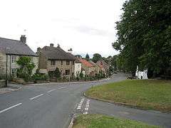
Burton Leonard
Burton Leonard is a village and civil parish in the Harrogate district of North Yorkshire, England, and approximately 7 miles (11 km) south from Ripon. In the 2001 Census, the population of the village was 654,[2] which had risen to 690 by the time of the 2011 Census.[1] In 2015, North Yorkshire County Council estimated the population had dropped to 670.[3]
| Burton Leonard | |
|---|---|
 | |
 Burton Leonard Location within North Yorkshire | |
| Population | 690 (2011 census)[1] |
| OS grid reference | SE327638 |
| • London | 185 mi (298 km) SSE |
| Civil parish |
|
| District |
|
| Shire county | |
| Region | |
| Country | England |
| Sovereign state | United Kingdom |
| Post town | HARROGATE |
| Postcode district | HG3 |
| Police | North Yorkshire |
| Fire | North Yorkshire |
| Ambulance | Yorkshire |
The village is typical of the area, with at its centre a green, one public house, a church, a small primary school, a cricket field and a village shop. Buses run daily from the green to the nearby towns of Harrogate and Ripon.
History
Burton Leonard is mentioned in the Domesday Book as having 30 ploughlands and belonging to King William.[4] The name of Burton derives from the Old English of Burh-Tūn (a fortified manor) and the name of Leonard, in this case, the dedication of the local church.[5][6]
The Church of St Leonard, is a grade II listed structure that was built in 1878, replacing an earlier structure.[7][8] Although the current dedication is for St Leonard, as was the dedication in the Late Middle Ages, the former church was dedicated to St Helen.[9][10] The parish was formerly a peculiar, though now it is in the Diocese of Leeds.[11][12] The primary school is the Burton Leonard Church of England Primary School, which was rated as outstanding by Ofsted in October 2019.[13]
Burton Leonard has just one pub, the Royal Oak,[14][15] after the Hare and Hounds closed in 2017 and it was demolished to make way for new housing.[16]
Station lane in the village leads westwards to the hamlet of Wormald Green, where the nearest railway station was.[17] This closed in 1962, and now the nearest railway station is in Knaresborough, 4 miles (6.4 km) to the south.[18][19] The village has a limited bus service between Ripon and Knaresborough.[20] The A61 road is to the north and the A1(M) motorway, is 5.6 miles (9 km) to the east at Boroughbridge.[8][21]
The underlying geology of the area is magnesian limestone, which many of the older buildings in the village are constructed of.[22] South of the village is Burton Leonard Lime Quarries SSSI, a 9.9-acre (4-hectare) site which supplied lime and building stone up until 1941.[23]
Notable people
- David Nobbs, comedy writer, creator of The Fall and Rise of Reginald Perrin, lived in the village.[24]
References
- UK Census (2011). "Local Area Report – Burton Leonard Parish (1170216984)". Nomis. Office for National Statistics. Retrieved 14 March 2018.
- UK Census (2001). "Local Area Report – Burton Leonard Parish (36UD017)". Nomis. Office for National Statistics. Retrieved 2 May 2020.
- "2015 Population Estimates Parishes" (PDF). northyorks.gov.uk. December 2016. p. 13. Retrieved 2 May 2020.
- "Burton [Leonard] | Domesday Book". opendomesday.org. Retrieved 2 May 2020.
- Ekwall, Eilert (1960). The concise Oxford dictionary of English place-names (4 ed.). Oxford: Oxford University Press. pp. 77–78. ISBN 0-19-869103-3.
- Chrystal, Paul (2017). The Place Names of Yorkshire; Cities, Towns, Villages, Rivers and Dales, some Pubs too, in Praise of Yorkshire Ales (1 ed.). Catrine: Stenlake. p. 21. ISBN 9781840337532.
- Historic England. "Church of St Leonard (Grade II) (1365719)". National Heritage List for England. Retrieved 2 May 2020.
- BLCAA 2010, p. 3.
- "Burton Leonard :: Survey of English Place-Names". epns.nottingham.ac.uk. Retrieved 2 May 2020.
- Liber Ecclesiasticus. An authentic statement of the revenues of the Established Church compiled from the report of the Commissioners appointed to inquire into the Revenues and Patronage of the established Church in England and Wales. London: Hamilton, Adams & Co. 1835. p. 35. OCLC 1064949647.
- "Genuki: Burton Leonard". www.genuki.org.uk. Retrieved 2 May 2020.
- "Burton Leonard: St Leonard's". www.achurchnearyou.com. Retrieved 2 May 2020.
- "Burton Leonard Church of England Primary School URN: 121555". reports.ofsted.gov.uk. 16 October 2019. Retrieved 2 May 2020.
- "The Royal Oak - Burton Leonard - Free House". www.theroyaloak-burtonleonard.co.uk. Retrieved 2 May 2020.
- BLCAA 2010, p. 8.
- Everett -, Steve (20 November 2019). "Developers launch £1.6m collection of new homes on former site of historic Yorkshire pub". Yorkshire Business Daily. Retrieved 2 May 2020.
- "History of Burton Leonard, in Harrogate and West Riding | Map and description". www.visionofbritain.org.uk. Retrieved 2 May 2020.
- "Postcode HG3 3SF in Burton Leonard - Postcode by address". postcodebyaddress.co.uk. Retrieved 2 May 2020.
- "Burton Leonard: the Harrogate District's Mary Poppins village". The Harrogate Advertiser. 10 January 2020. Retrieved 2 May 2020.
- "Burton Leonard – bustimes.org". bustimes.org. Retrieved 2 May 2020.
- "299" (Map). Ripon & Boroughbridge. 1:25,000. Explorer. Ordnance Survey. 2015. ISBN 9780319245514.
- BLCAA 2010, p. 9.
- "Burton Leonard Lime Quarries | YWT". www.ywt.org.uk. Retrieved 2 May 2020.
- "Tributes paid to North Yorkshire comedy writer David Nobbs". York Press. 10 August 2015. Retrieved 2 May 2020.
Sources
- Burton Leonard Conservation Area Appraisal (PDF). harrogate.gov.uk (Report). February 2010. Retrieved 2 May 2020.