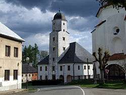
Branná
Branná (until 1949 Kolštejn German: Goldenstein) is a village and municipality (obec) in Šumperk District in the Olomouc Region of the Czech Republic. From 1938 to 1945 it was one of the municipalities in Sudetenland.
Branná | |
|---|---|
Municipality | |
 | |
 Flag  Coat of arms | |
 Branná | |
| Coordinates: 50°9′41″N 17°1′26″E | |
| Country | |
| Region | Olomouc |
| District | Šumperk |
| Area | |
| • Total | 14.56 km2 (5.62 sq mi) |
| Elevation | 633 m (2,077 ft) |
| Population (2009) | |
| • Total | 303 |
| • Density | 21/km2 (54/sq mi) |
| Postal code | 788 25 |
| Website | http://www.branna.eu |
The municipality covers an area of 14.56 square kilometres (5.62 sq mi), and has a population of 303 (as at 2 January 2009).
Branná lies approximately 23 kilometres (14 mi) north of Šumperk, 66 km (41 mi) north of Olomouc, and 186 km (116 mi) east of Prague.
This article is issued from Wikipedia. The text is licensed under Creative Commons - Attribution - Sharealike. Additional terms may apply for the media files.