Bouca
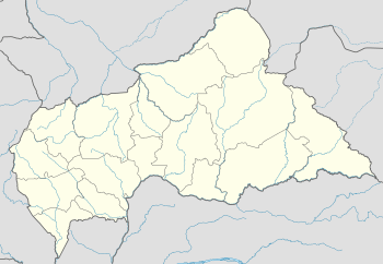
Bouca is a town located in the Central African Republic prefecture of Ouham. It is not far east of Bossangoa at the Fafa river.
Bouca | |
|---|---|
 Bouca Location in Central African Republic | |
| Coordinates: 6°30′N 18°17′E | |
| Country | Central African Republic |
| Prefecture | Ouham |
| Population (2003) | 12,280 |
On 21 March 2013, the town was overtaken by rebels of the Séléka coalition.
Climate
Köppen-Geiger climate classification system classifies its climate as tropical wet and dry (Aw).[1]
| Climate data for Bouca | |||||||||||||
|---|---|---|---|---|---|---|---|---|---|---|---|---|---|
| Month | Jan | Feb | Mar | Apr | May | Jun | Jul | Aug | Sep | Oct | Nov | Dec | Year |
| Average high °C (°F) | 37.3 (99.1) |
39.9 (103.8) |
38.2 (100.8) |
38 (100) |
36.1 (97.0) |
33.4 (92.1) |
32.7 (90.9) |
32.5 (90.5) |
32.6 (90.7) |
33.6 (92.5) |
34.6 (94.3) |
35.5 (95.9) |
35.4 (95.6) |
| Daily mean °C (°F) | 24 (75) |
26.9 (80.4) |
28 (82) |
28.8 (83.8) |
27.9 (82.2) |
26 (79) |
25.9 (78.6) |
25.4 (77.7) |
25.4 (77.7) |
25.9 (78.6) |
25 (77) |
24 (75) |
26.1 (78.9) |
| Average low °C (°F) | 10.7 (51.3) |
14 (57) |
17.8 (64.0) |
19.7 (67.5) |
19.7 (67.5) |
18.6 (65.5) |
19.2 (66.6) |
18.4 (65.1) |
18.3 (64.9) |
18.3 (64.9) |
15.4 (59.7) |
12.5 (54.5) |
16.9 (62.4) |
| Average precipitation mm (inches) | 0 (0) |
9 (0.4) |
48 (1.9) |
99 (3.9) |
132 (5.2) |
162 (6.4) |
232 (9.1) |
233 (9.2) |
224 (8.8) |
184 (7.2) |
28 (1.1) |
2 (0.1) |
1,353 (53.3) |
| Source: Climate-Data.org, altitude: 4361[1] | |||||||||||||
gollark: This is a bit densely packed but generally fine.
gollark: Apparently my CPU is at 49 degC, the WiFi adapter is at 33 degC, the chipset is at 50.5 degC, and the "ACPI interface" says 55.
gollark: Intel® 64 architecture delivers 64-bit computing on server, workstation, desktop and mobile platforms when combined with supporting software.¹ Intel 64 architecture improves performance by allowing systems to address more than 4 GB of both virtual and physical memory, however.
gollark: They might be. If you flip all the belts and splitters.
gollark: Oh, I got the direction wrong. Still valid.
See also
References
- "Climate: Bouca - Climate graph, Temperature graph, Climate table". Climate-Data.org. Retrieved 8 November 2013.
This article is issued from Wikipedia. The text is licensed under Creative Commons - Attribution - Sharealike. Additional terms may apply for the media files.
