Botoșani County
Botoșani County (Romanian pronunciation: [botoˈʃanʲ] (![]()
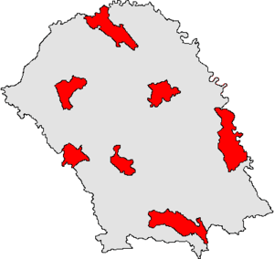
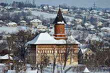
Botoșani County Județul Botoșani | |
|---|---|
County | |
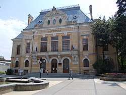 Former Botoșani County Prefecture | |
 Coat of arms | |
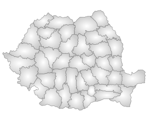
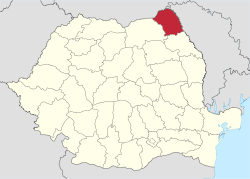 Location of Botoșani County in Romania | |
| Coordinates: 47.84°N 26.82°E | |
| Country | |
| Development region1 | Nord-Est |
| Historic region | Moldavia |
| Capital city (Reședință de județ) | Botoșani |
| Government | |
| • Type | County Board |
| • President of the County Board | Mihai Țâbuleac (PD-L) |
| • Prefect2 | Adrian Constantinescu |
| Area | |
| • Total | 4,986 km2 (1,925 sq mi) |
| Area rank | 29th in Romania |
| Population (2011) | |
| • Total | 412,626 |
| • Rank | 22nd in Romania |
| • Density | 83/km2 (210/sq mi) |
| Time zone | UTC+2 (EET) |
| • Summer (DST) | UTC+3 (EEST) |
| Postal Code | 71wxyz3 |
| Area code(s) | +40 x314 |
| Car Plates | BT5 |
| GDP | US$ 1.726 billion (2015) |
| GDP/capita | US$ 4,18 (2015) |
| Website | County Board County Prefecture |
| 1The developing regions of Romania have no administrative role. They were formed just to attract funds from the European Union 2 as of 2007, the Prefect is not a politician, but a public functionary. He (or she) is not allowed to be a member of a political party, and is banned to have any political activity in the first six months after the resignation (or exclusion) from the public functionary corps 3w, x, y, and z are digits that indicate the city, the street, part of the street, or even the building of the address 4x is a digit indicating the operator: 2 for the former national operator, Romtelecom, and 3 for the other ground telephone networks 5used on both the plates of the vehicles that operate only in the county limits (like utility vehicles, ATVs, etc.), and the ones used outside the county | |
Demographics
As of 31 October 2011, it had a population of 412,626 and the population density was 83/km2.[1]
- Romanians – 94.1%
- Romani – 1%
- Ukrainians – 0.2%
- Lipovans – 0.1%
- Other ethnicities – 0.1%
- Unknown ethnicity – 4.6%
| Year | County population[2][3] |
|---|---|
| 1948 | 385,236 |
| 1956 | |
| 1966 | |
| 1977 | |
| 1992 | |
| 2002 | |
| 2011 | |
| 2016 | |
Geography
- it is situated between Siret and Prut, in the north-east part of the county, Ukraine in the north and Moldova in the east. At the west and south it has borders with the Suceava County and Iași County.
- it has a total area of 4,986 km2 (2.1% of the Romanian territory).
- the relief is a high plain, between the valleys of the Siret River, the Prut River and its affluent the Jijia River.
- temperate climate, influenced by the eastern air masses of the continent.
Economy
This is a predominantly agricultural county.
The predominant industries in the county are:
- Textile industry
- Food industry
- Electrical components industry
- Glass and porcelain industry
At Stânca-Costești there is one of the greatest hydroelectric power plants in Romania.
Politics
The Botoșani County Council, elected at the 2016 local government elections, is made up of 33 counselors, with the following party composition:[4]
| Party | Seats | Current County Council | ||||||||||||||||||
|---|---|---|---|---|---|---|---|---|---|---|---|---|---|---|---|---|---|---|---|---|
| Social Democratic Party | 18 | |||||||||||||||||||
| National Liberal Party | 15 | |||||||||||||||||||
Administrative divisions
Botoșani County has 2 municipalities, 5 towns and 71 communes
- Municipalities
- Towns
- Communes
- Adășeni
- Albești
- Avrămeni
- Bălușeni
- Blândești
- Brăești
- Broscăuți
- Călărași
- Cândești
- Concești
- Copălău
- Cordăreni
- Corlăteni
- Corni
- Coșula
- Coțușca
- Cristești
- Cristinești
- Curtești
- Dersca
- Dângeni
- Dimăcheni
- Dobârceni
- Drăgușeni
- Durnești
- Frumușica
- George Enescu
- Gorbănești
- Havârna
- Hănești
- Hilișeu-Horia
- Hlipiceni
- Hudești
- Ibănești
- Leorda
- Lozna
- Lunca
- Manoleasa
- Mihai Eminescu
- Mihăileni
- Mihălășeni
- Mileanca
- Mitoc
- Nicșeni
- Păltiniș
- Pomârla
- Prăjeni
- Rădăuți-Prut
- Răchiți
- Răuseni
- Ripiceni
- Roma
- Românești
- Santa Mare
- Stăuceni
- Suharău
- Sulița
- Șendriceni
- Știubieni
- Todireni
- Trușești
- Tudora
- Ungureni
- Unțeni
- Văculești
- Viișoara
- Vârfu Câmpului
- Vlădeni
- Vlăsinești
- Vorniceni
- Vorona
Historical county
Județul Botoșani | |
|---|---|
County (Județ) | |
 The Botoşani County Prefecture building from the interwar period, currently the county museum. | |
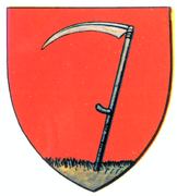 Coat of arms | |
 | |
| Country | |
| Historic region | Moldavia |
| Capital city (Reședință de județ) | Botoșani |
| Area | |
| • Total | 3,077 km2 (1,188 sq mi) |
| Population (1930) | |
| • Total | 218,258 |
| • Density | 71/km2 (180/sq mi) |
| Time zone | UTC+2 (EET) |
| • Summer (DST) | UTC+3 (EEST) |
During the years between the world wars, the county extended over different territory than currently. It was located in the northeastern part of Romania, in the northeast of the region or Moldavia. The county included the southern part of the present county and the northern part of the current Iași County. It was bordered to the west by the counties of Suceava and Baia, to the north by Dorohoi, to the east by Bălți, and to the south with Iaşi.
Administration

In 1930, the county was divided into three districts (plăṣi):[5]
- Plasa Botoșani
- Plasa Jijia
- Plasa Siret
Administration was re-organized in 1938, comprising 4 districts:
- Plasa Bucecea (with 52 villages, headquartered in Târgu Bucecea)
- Plasa Răchiți (with 73 villages, headquartered in Botoșani)
- Plasa Sulița (with 49 villages, headquartered in Hârlău)
- Plasa Ștefănești (with 77 villages, headquartered in Ștefănești)
Population
According to the 1930 census data, the county population was 218,258 inhabitants, ethnically, 88.8% were Romanians, 9.0% were Jews, as well as other minorities. From the religious point of view, 89.4% were Eastern Orthodox, 9.2% Jewish, 0.7% Roman Catholic, as well as other minorities.
Urban population
In 1930, the county's urban population was 50,320 inhabitants, comprising ethnically 64.9% Romanians, 31.3% Jews, 0.9% Germans, as well as other minorities. From the religious point of view, the urban population was composed of Eastern Orthodox (64.5%), Jewish (32.3%), Roman Catholic (2.1%), as well as other minorities.
People
Natives of the county include:
See also
- Global storm activity of 2010
- 2010 Romanian floods
- Miletin River
References
| Wikimedia Commons has media related to Botoșani County. |
- Tab8. Populația stabilă după etnie – județe, municipii, orașe, comune
- Tab1. Populația la recensămintele din anii 1948, 1956, 1966, 1977, 1992, 2002 și 2011 – categorii de localități și județe
- "Populaţia României pe localitati la 1 ianuarie 2016" (in Romanian). INSSE. 6 June 2016. Archived from the original on 27 October 2017. Retrieved 27 October 2017.
- "Mandate de CJ pe judete si competitori" (in Romanian). Biroul Electoral Central. 10 June 2016. Retrieved 16 June 2016.
- Portretul României Interbelice - Județul Botoșani
