Auckland Harbour Bridge
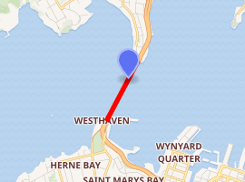
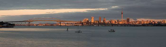
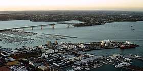
The Auckland Harbour Bridge is an eight-lane motorway bridge over the Waitematā Harbour in Auckland, New Zealand. It joins St Marys Bay on the Auckland city side with Northcote on the North Shore side. It is part of State Highway 1 and the Auckland Northern Motorway. The bridge is operated by the NZ Transport Agency (NZTA).[4] It is the second-longest road bridge in New Zealand, and the longest in the North Island.[5]
Auckland Harbour Bridge | |
|---|---|
.jpg) Auckland Harbour Bridge, seen from the North Shore looking toward Auckland City | |
| Coordinates | 36°49′46″S 174°44′47″E |
| Carries | 8 lanes of New Zealand State Highway 1 (as the Auckland Northern Motorway) |
| Crosses | Waitematā Harbour |
| Locale | Auckland, New Zealand |
| Maintained by | NZ Transport Agency |
| Characteristics | |
| Design | Box truss |
| Material | Steel |
| Total length | 1,020 metres (3,350 ft) |
| Longest span | 243.8 metres (800 ft) |
| No. of spans | 9 |
| Load limit | 13 tonnes (13 long tons; 14 short tons) on outside lanes |
| Clearance above | 4.8 metres (16 ft)[1] |
| Clearance below | 43.27 metres (142.0 ft) at high tide |
| History | |
| Designer | Freeman Fox & Partners[2] |
| Constructed by | Dorman Long and Cleveland Bridge & Engineering Company |
| Construction start | 1954 |
| Construction end | April 1959[3] |
| Opened | 30 May 1959 |
| Statistics | |
| Toll | Until 31 March 1984 |
| |
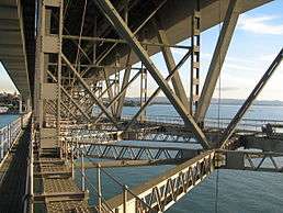
The original inner four lanes, opened in 1959, are of box truss construction. Two lanes that were added to each side in 1968–1969 are of orthotropic box structure construction[6] and are cantilevered off the original piers. The bridge is 1,020 m (3,348 ft) long, with a main span of 243.8 metres, rising 43.27 metres above high water,[7] allowing ships access to the deepwater wharf at the Chelsea Sugar Refinery, one of the few such wharves west of the bridge, the proposed Te Atatū port not having been built.[8]
While often considered an Auckland icon, criticism has included complaints that it mimics the Sydney Harbour Bridge in copyist fashion.[9] Many see the construction of the bridge without walking, cycling, and rail facilities as a big oversight. However, in 2016, "SkyPath", an add-on structure providing a walk-and-cycleway, received Council funding approval and planning consent.[10][11]
About 170,000 vehicles cross the bridge each day (as of 2019), including more than 1,000 buses, which carry 38% of all people crossing during the morning peak.[12]
Background
Prior to the opening of the bridge in 1959, the quickest way from Auckland to the North Shore was by passenger or vehicular ferry. By road, the shortest route was via the Northwestern Motorway (then complete only between Great North Road and Lincoln Road), Massey, Riverhead, and Albany, a distance of approximately 50 km (31 mi).[13][14]
As early as 1860, engineer Fred Bell, commissioned by North Shore farmers who wanted to herd animals to market in Auckland, had proposed a harbour crossing in the general vicinity of the bridge. It would have used floating pontoons, but the plan failed due to the £16,000 cost estimate ($1.9 million, adjusted for inflation as of March 2017).[14]
In the 1950s, when the bridge was being built, North Shore was a mostly rural area of barely 50,000 people, with few jobs and a growth rate half that of Auckland south of the Waitemata Harbour. Opening up the area via a new route unlocked the potential for further expansion of Auckland.[14]
Construction
Initial structure
The recommendations of the design team and the report of the 1946 Royal Commission were for five or six traffic lanes, with one or two of them to be reversed in direction depending on the flow of traffic, and with a footpath for pedestrians on each side. The latter features were dropped for cost reasons before construction started, the First National Government of New Zealand opting for an 'austerity' design of four lanes without footpaths, and including an approach road network only after local outcry over traffic effects.[15] The decision to reduce the bridge in this way has been called "a ringing testament to [...] the peril of short-term thinking and penny-pinching".[15]
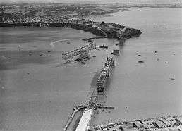
The bridge took four years to build, with Dorman Long and the Cleveland Bridge & Engineering Company being the contractors.[2] Hundreds of labourers were employed on the construction including 180 men sent out from the UK. Progress was slowed with the workers going on strike in 1956 and 1957.[16] The large steel girder sections were partially pre-assembled, then floated into place on construction barges. One of the main spans was almost lost during stormy weather when the barge began to drift, but the tugboat William C Daldy won a 36-hour tug-of-war against the high winds.[17]
Completed in April 1959, three weeks ahead of schedule,[18] the bridge was officially opened on 30 May 1959 by the Governor-General Lord Cobham.[19][20] An open day had been held, when 106,000 people had walked across.[3]
Either three or four men had been killed by accidents during construction, and the names of three of them are recorded on a memorial plaque underneath the bridge at the Northcote end.[21][22]
Paid for by government-backed loans,[21] the bridge started out as a toll bridge, the first one in New Zealand,[15] with toll booths at the northern end for north-bound and south-bound traffic. Tolls were originally 2/6 (2 shillings and six pence: approximately $5.50[23] in 2018) per car but were reduced to 2/- (2 shillings: approximately $4.47[23] in 2018) after 15 months of operation. The toll remained at 2 shillings until New Zealand changed to decimal currency in July 1967, when that amount became 20 cents in the conversion. It was increased in 1980 from 20 to 25 cents (approximately $1.21[23] in 2018).[24] Tolling was later made north-bound only before being discontinued on 31 March 1984, and the booths were removed.[25] This was in line with political commitments that tolls would be charged only until construction costs were paid off.
Some critics have alleged that the routing of State Highway 1 over the bridge was motivated by the need to create toll revenue, and led to a decades-long delay on finishing the Western Ring Route around Auckland, significantly contributing to the need for a massive motorway through the city centre of Auckland and severely damaging inner-city suburbs such as Freemans Bay and Grafton.[26]
'Nippon clip-ons'
The bridge was originally built with four lanes for traffic. Owing to the rapid expansion of suburbs on the North Shore and increasing traffic levels, it was soon necessary to increase capacity – by 1965, the annual use was about 10 million vehicles, three times the original forecast.[15]
In 1969, only ten years after opening, two-lane box girder clip-on sections were added to each side, doubling the number of lanes to eight. The sections were manufactured by Ishikawajima-Harima Heavy Industries of Japan, which led to the nickname 'Nippon clip-ons'. The selection of the company was considered a bold move at the time, barely 20 years after WWII and with some considerable anti-Japanese sentiment still existing.[27] The costs of the additions were much higher than if the extra lanes had been provided initially.[15]
The clip-ons have been plagued by significant issues. In 1987, cracks required major repair works,[28] and in 2006, further cracks and signs of material fatigue were found. The clip-ons were originally to have a life expectancy of 50 years. Auckland City Council's Transport Committee requested Transit New Zealand to investigate the future of the clip-ons as part of its ten-year plan. Transit noted that the plan already includes some funding for bridge maintenance.[29]
In May 2007, Transit proposed a bylaw change banning vehicles over 4.5 tonnes from the outside lane on each clip-on to reduce stress on the structure.[30] This was changed in July 2007 to a bylaw banning vehicles of 13 tonnes or more, based on the high level of voluntary compliance during the previous months.[31]
In 2007, it was announced that NZ$45 million in maintenance work on the clip-ons was brought forward as part of good practice. In October 2007, a 2006 report from Beca Group surfaced in the press, noting that the clip-ons were at risk of catastrophic, immediate failure in circumstances such as a traffic jam trapping a large number of trucks. Transit noted that this situation was extremely unlikely, and measures already implemented would prevent it from occurring.[32] In January 2008, it became known that even after the multimillion-dollar maintenance works, a full ban for trucks on all clip-on lanes might be required, or the working life could be reduced to only ten more years.[33]
In late 2009, it was announced that due to greater than expected complexity of the task and increasing material costs for the 920 tons of reinforcing material instead of the approximately half amount of that originally envisaged, clip-on maintenance costs had increased by a further NZ$41 million.[34][35] NZTA noted that the clip-ons would not be able to be strengthened again after the current works were finished. However, after completion of the upgrade, the bridge would have a further life of between 20 and 40 years if truck restrictions were reintroduced in 10–20 years on the northbound clip-on.[35][36]
Traffic management
A "tidal flow" system is in place, with the direction of the two centre lanes changed to provide an additional lane for peak-period traffic. During the morning peak, five of the eight lanes are for southbound traffic; in the afternoon, five lanes are northbound. At other times, the lanes are split evenly, but peak traffic has become proportionately less – in 1991 there was often a higher than 3:1 difference in directional traffic; in 2006, this had dropped to around 1.6:1. The bridge has an estimated capacity of 180,000 vehicles per day, and in 2006 had an average volume of 168,754 vehicles per day (up from 122,000 in 1991).[37]
In March 1982, the Ministry of Transport and Auckland Harbour Bridge Authority conducted a week-long traffic blitz in an attempt to improve the standard of driving. Of the 600,000 vehicles which used the bridge over this period, 6,000 were stopped, with half of those receiving a ticket and the rest cautioned. A second blitz was held for 36 hours a few weeks later.[38][39]
For many years, lane directions were indicated by overhead signals. In the late 1980s, a number of fatal head-on accidents occurred when vehicles crossed lane markings into the path of oncoming traffic. In 1990, a movable concrete safety barrier was put in place to separate traffic heading in opposite directions and eliminate head-on accidents. Two specially designed barrier transfer machines moved the barrier by one lane four times a day,[28] at a speed of 6 km/h. It took 40 minutes to move the barrier, which was the first of its kind in the world.
In March 2009, the barrier transfer machines, which had lasted four times their original design life of five years, and the barrier were replaced. The new machines are capable of moving the barrier in half the time the old machines did. The concrete barrier blocks and the metal expansion blocks have been reduced in width by 200 mm, giving more width in the lanes either side of the barrier.
As part of the Victoria Park Tunnel project, the moveable barrier has been extended southwards to the Fanshawe Street onramp.[40][41]
Event management
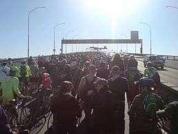
As part of large events such as the Auckland Marathon, normal motorway restrictions on access are sometimes relaxed. December 2011 was the first time that cyclists were officially allowed on the bridge, for a race / community cycling event organised by Telstra Clear, Auckland Transport, NZTA and Cycle Action Auckland, also allowing cyclists on the Northern Busway. The up to 9000 riders were protected by 160 stationary buses used as a 'guard of honour' between the bridge end and the Northern Busway from traffic on the rest of the motorway, which will stay open.[42][43][44]
Proposed walk- and cycleway
Original proposal
When the bridge was built, rail lines and walking and cycling paths were dropped for cost reasons, and neither were they included during the clip-on construction (people can walk on the span only via guided tours). In 2007 discussions about the addition of a cycle and footpath link was mooted. Transit noted that this would cost between NZ$20 million and $40 million, but public support has been polled as very high.[45] The GetAcross group and Cycle Action Auckland argue that lower-cost options are available, and that provision for a walk- and cycleway could relatively easily be included in the bridge strengthening works currently being planned for the clip-ons.
The GetAcross group is showcasing its proposed walking/cycling solution, called SkyPath, on its website and invites visitors to sign a petition supporting or opposing the proposal.[46]
A 2008 proposal to modify the clip-ons and potentially widen them to add walking and cycling paths met with different reactions. While Auckland Regional Council and North Shore City Council voted to support it (under certain conditions), Auckland City Council considered the costs to be too high. Other stakeholders such as the NZ Transport Agency (NZTA) considered the proposal as not having enough merit for the $22–53 million price tag, though campaigners note that the costs cited for the project include 45% contingencies.[47] A proposal from the Auckland Regional Council (one of the proponents) to open up part of the clip-on structure for a walking / cycling trial use over several summer weekends, to show whether it would attract enough users, did not go forward.[47]
Protests
On Sunday, 24 May 2009, thousands of people crossed the bridge as a part of a protest by GetAcross against the bridge not providing walking and cycling access, and against what the group perceives to be the authorities' negative and obstructionist attitude towards such access.[48] A crossing either as part of the protest or as part of the official 50-year anniversary celebrations had been forbidden by NZTA because of the costs and traffic difficulties claimed for a managed crossing. However, after several speeches, including by Auckland Regional Council Chairman Mike Lee, several people made their way around the police cordon onto the bridge. At that stage police closed the northbound lanes to traffic, bringing State Highway 1 to a stop. The remainder of the protesters moving onto the bridge, which was not resisted any more by the police. No accidents, violence or arrests were reported,[48] and protesters left the bridge approximately an hour later, many having crossed to the North Shore and back.
The protest created a wide spectrum of responses in the media and in public perception, from being labelled a dangerous stunt representative of an increasingly lawless, anarchic society[49] to being considered a successful signal to authorities to give more weight to the demands and the public backing of the walk and cycleway proponents. Authorities noted that they were investigating whether any of the protesters would face fines or charges.[50] NZTA representatives noted that they were disappointed at what they considered the broken word of the organisers of the protest, and remarked that it would take 30 more years before walking and cycling could likely be provided (see also "Second Harbour Crossing" below).[48] NZTA were criticised as having brought the situation at least partly onto themselves by choosing the easy route of forbidding the protest crossing.[49] Several political protest marches (especially hikois) had been allowed to cross the bridge.
Updated proposal
Because of the costs of the proposal and increasing information about the problematic state of the clip-ons, the GetAcross campaign in late 2009 proposed an alternative solution, with a single shared walking and cycling path slung under the eastern clip-on. As confirmed by NZTA,[35] this clip-on has significantly more remaining load capacity (it is used by fewer heavy trucks, being the route of (often empty) trucks returning to Ports of Auckland) and as the proposal would not require widening, the costs have been preliminarily assessed as of the order of NZ$12 million.[51]
The group proposes to raise the majority of the funding via a loan backed by small tolls, of the order of NZ$1 for regular users. NZTA noted that it would be considering the proposal, should funding be able to be secured by the campaigners.[51]
In 2011, the proposal got new public support when Auckland Mayor Len Brown agreed that a walk- and cycleway was a desirable goal, and instructed Auckland Transport to add it to its strategic priorities. The walk- and cycleway is also to be included in the city centre masterplan. Three council-controlled organisations (CCOs) – Auckland Transport, the Waterfront Development Agency and the Tourism, Events and Economic Development Agency - indicated support for the proposal, as has the Heart of the City (Auckland CBD) business association.[52]
In August 2011, an editorial in the New Zealand Herald gave conditional support to the newest proposal, noting that a toll-based funding model and the partially enclosed weather-protected design of the $23 million proposal by Hopper Developments would appear to cover most concerns.[53]
Approval
In 2014, the proposed walk and cycleway was publicly notified, and consent was given in 2015. However, this was appealed by three local groups (two which later dropped out of the appeal). The decision of the original hearing was upheld in December 2016, and the last appeal rejected by the Environment Court. In the meantime, Council had already provided in principle approval for a public-private partnership funding model, in a unanimous support vote earlier in 2016.[10][11]
A 2019 announcement said that work on the walking and cycling "clipon" could start in 2020.[54][55] But mayoral candidate John Tamihere proposed replacement with a 10-lane lower-level plus rail and cvcling/pedestrian facilities on an upper level.[56]
Utilities
The bridge supports several utility services, including water and gas pipelines and fibre-optic telecommunications cables.[57]
Transpower reached agreement with Transit in 2005 for the installation of cable supports beneath the bridge for a future cross-harbour power cable.[58] In 2012, Transpower installed three 220,000-volt cables on the bridge, linking Hobson Street substation in the Auckland CBD to the Wairau Road substation on the North Shore.
Bungy jumping
Bungy operator AJ Hackett operates a 40-m bungy jump from the bridge and offers a bridge climb with views of the city and the harbour.[59]
Second Harbour Crossing
Almost since the bridge as built reached capacity, before extension via the clip-ons, a second crossing of the harbour was mooted. The high costs and the difficulties of connecting it to the motorway network have so far caused plans to remain at concept stage. In 2008, a study group narrowed down around 160 options to a multi-tunnel link approximately one km east of the bridge, with up to four individual tunnels for motorway, public transport and rail. The proposal has not continued to a political decision or funding stage, though designations are being protected to ensure that development will not prevent the tunnels being built.
Suicides
The bridge sees a small number of suicide attempts, with between one and two people each year dying from jumping into the Waitematā Harbour.[60]
See also
Specific
- Central Motorway Junction, the major motorway junction connecting southeast of the bridge
- Newmarket Viaduct, similarly important traffic bottleneck on other side of Auckland CBD
- Western Reclamation, large industrial area east of the bridge, possible southern end of second crossing
References
- "General operating requirements that apply to all overdimension vehicles – Factsheet 53: Overdimension vehicles and loads – New Zealand Transport Agency". July 2005. Retrieved 2 June 2009.
- Engineering to 1990, IPENZ, Engineering Publications Co Ltd, Page 11
- Opening day and ceremonies New Zealand Government. Retrieved 5 June 2008.
- "Auckland Harbour Bridge". NZ Transport Agency. Archived from the original on 15 March 2011. Retrieved 9 April 2012.
- What is the longest bridge in New Zealand? Archived 19 June 2008 at the Wayback Machine (from the Transit New Zealand FAQ webpage. Retrieved 9 June 2008.)
- "Auckland Harbour Bridge". Engineering New Zealand. 2019. Retrieved 6 June 2019.
- 1951–1961 The Auckland Harbour Bridge Authority Archived 7 February 2007 at the Wayback Machine (Auckland Harbour Board publication, 1960s)
- "Judges favour owner's descendants in latest – last? – Te Atatū port land case". Bob Dey Property Report. 22 October 2008. Archived from the original on 23 May 2010.
- "Get foreign help to build next bridge". The Sunday Star-Times. 18 October 2009 – via Stuff.
- "Auckland Council vote 'yes' on SkyPath". 21 July 2016. Retrieved 30 December 2016.
- "SkyPath over Auckland Harbour Bridge gets green light". Radio New Zealand. 16 December 2016. Retrieved 30 December 2016.
- "The next harbour crossing: road and rail, or just rail". The New Zealand Herald. 9 March 2019. Retrieved 9 March 2019.
- Auckland to North Shore: pre-Harbour Bridge
- "The history of the Auckland Harbour Bridge". The New Zealand Herald. 25 May 2009.
- "Editorial: Bridge at 50 uniting the city at last". The New Zealand Herald. 30 May 2009. Retrieved 17 September 2011.
- "IPENZ Engineering Heritage". www.ipenz.org.nz. Retrieved 3 October 2015.
- References provided within the William C Daldy article.
- People who built the Bridge (from the Archives New Zealand, New Zealand Government website. Retrieved 5 June 2008.)
- Auckland – Our Bridge (historical video via YouTube. Retrieved 27 July 2008.)
- Record of 20 Years Activities 1951–1971 – Auckland Harbour Bridge Authority
- "Happy 50th birthday harbour bridge", North Shore Times via Stuff.co.nz, 21 May 2009
- Bridge worker fatalities Archives New Zealand, New Zealand Government. Retrieved 5 June 2008.
- "Inflation calculator – Reserve Bank of New Zealand". Retrieved 9 March 2019.
- Dearnaley, Mathew (5 July 2011). "$6 toll to cross Auckland Harbour Bridge". The New Zealand Herald. Retrieved 26 July 2013.
- Bridging the Gap, Slide 15, North Shore City Libraries. Retrieved 8 June 2008.
- "Michael Lee: Sins of the fathers – legacy of harbour bridge". The New Zealand Herald. 1 June 2009. Retrieved 17 September 2011.
- Bridging the Gap, Slide 14 Archived 14 October 2008 at the Wayback Machine North Shore City Libraries. Retrieved 8 June 2008.)
- Bridging the Gap, Slide 16 Archived 14 October 2008 at the Wayback Machine North Shore City Libraries. Retrieved 8 June 2008.
- "Harbour Bridge future questioned". Television New Zealand, 12 March 2006
- "Trucks to be banned from clip-ons", Television New Zealand, 4 May 2007
- Dearnaley, Mathew (17 July 2007). "Transit bans large trucks from clip-ons to extend life of lanes". The New Zealand Herald. Retrieved 17 September 2011.
- "'Catastrophic failure' warning on Harbour Bridge", The New Zealand Herald, 14 October 2007
- Savage, Jared (4 January 2009). "Harbour Bridge risking serious failure". The New Zealand Herald. Retrieved 17 September 2011.
- (Press Release) "Key decisions on Auckland Harbour Bridge and third harbour crossing". NZ Transport Agency, 2 December 2009. Retrieved 2 December 2009.
- "Minister raises hopes for new harbour link", The New Zealand Herald, 3 December 2009
- "Bridge upgrade to proceed, despite blow-out", The New Zealand Herald, 2 December 2009
- Dearnaley, Mathew (11 July 2007). "Traffic decline casts shadow on $3b tunnel". The New Zealand Herald. Retrieved 17 September 2011.
- Parliamentary Debates. 444. 1982. p. 915.
- Parliamentary Debates. 443. 1982. p. 728.
- "Gateway to Auckland", The Aucklander, 12 November 2009, Page 5
- "Victoria Park Tunnel – Construction Update Newsletter". New Zealand Transport Agency. 13 July 2010.
- "Cyclist given Harbour Bridge access in historic event". TV New Zealand. 17 June 2011. Retrieved 18 June 2011.
- "Bridge Bike Ride A Celebration of Cycle Culture in the Super City". Voxy Newswire. 17 June 2011. Retrieved 18 June 2011.
- Dearnaley, Mathew (20 June 2011). "Buses protect cyclists on mass bridge crossing". The New Zealand Herald. Retrieved 20 June 2011.
- Dearnaley, Mathew (14 December 2007). "Cycle, walking lane on bridge wins support". The New Zealand Herald. Retrieved 17 September 2011.
- Dearnaley, Mathew (6 March 2008). "Bike campaigners find more room on bridge". The New Zealand Herald. Retrieved 17 September 2011.
- Dearnaley, Mathew (12 November 2008). "Drive for weekend cycle lane on bridge". The New Zealand Herald. Retrieved 17 September 2011.
- "People power breaks barricades". The New Zealand Herald, 24 May 2009
- "Garth George: An anarchic society that needs a good zap", The New Zealand Herald, 28 May 2009
- "Harbour Bridge marchers may face fines, charges". The New Zealand Herald, 26 May 2009
- Dearnaley, Mathew (27 November 2009). "Toll could pave the way for pedestrians". The New Zealand Herald. Retrieved 17 September 2011.
- Dearnaley, Mathew (14 February 2011). "Cycle and walking path on bridge gets Brown's tick". The New Zealand Herald. Retrieved 18 June 2011.
- "Editorial: People path on bridge a top idea, if user pays". The New Zealand Herald. 27 August 2011. Retrieved 28 August 2011.
- "Auckland Harbour Bridge marks its 60th birthday by going back to the future". Stuff (Fairfax). 30 May 2019.
- "Skypath plans-scrapped as NZTA releases new design for Auckland harbour bridge walkway". Stuff (Fairfax). 22 May 2019.
- "John- Tamihere's 18lane Auckland harbour bridge plan would be costly and disruptive". Stuff (Fairfax). 17 August 2019.
- "Auckland Engineering Lifelines Project – Final Report Stage 1 – Chapter 5". Auckland Regional Council. November 1999. Archived from the original on 7 February 2013. Retrieved 15 April 2012.
- "Electricity Commission Questions on 220 kV Auckland CBD Cable Ducts Preparatory Expenditure Application". Transpower. 16 December 2005. Retrieved 15 April 2012.
- Auckland Bride Climb and Bungy
- "Man survives leap from Auckland Harbour Bridge". The New Zealand Herald. 27 January 2010. Retrieved 30 January 2010.
External links
| Wikimedia Commons has media related to Auckland Harbour Bridge. |
- NZTA Auckland Harbour Bridge – home page
- Engineering Heritage – Auckland Harbour Bridge (from the IPENZ website)
- Auckland Harbour Bridge at Structurae
- Historical photos (from the Transit New Zealand website)
- Get Across (website advocating a Harbour Bridge walking and cycling facility)
- Photographs of Auckland Harbour Bridge held in Auckland Libraries' heritage collections.